Refuge de Temple Écrins-trekking from La Bérarde
Add to my favorites

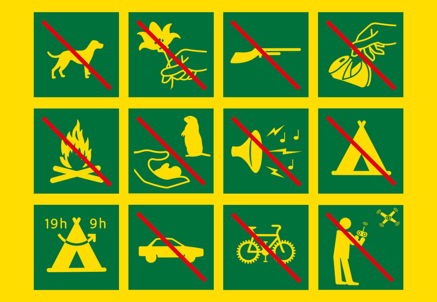
Caution! Zone of vigilance near the route
Aigle royal - du 01/01/2026 au 31/08/2026 In progress
Aigle royal - du 01/01/2026 au 31/08/2026 In progress
After a climb through the forest, discover a breathtaking view of the Écrins mountain range and the Pilatte glacier.
The characteristics of the route.

Saint-Christophe-en-Oisans (38)
- Distance 16.01 km
- Elevation gain 790 m
- Elevation lost 790 m
- Min. elevation 1663 m
- Max. elevation. 2406 m
- Duration (depending on pace) 5h45
- Marking Yes
TECHNICAL INFORMATION :
Departure: La Bérarde-Combe Noire
Difference in altitude: 825m
Duration: 3 h outward journey and 2 h 45 return journey
Distance: 16 km
Level: Difficult hike
ITINERARY:
From the shuttle bus stop follow the road to La Bérarde, take the track on your right then cross the footbridge. Follow the path for about 500 m, then turn around and you can see the Meije, the Grand Pic and the Glacier Carré. The 45-minute climb up to the Plan du Carrelet will give you a good workout.
Then begin the ascent to the Refuge de Temple Ecrins. Leave the main path and take the path that rises to the left at the intersection of the Pilatte and Temple Ecrins valleys. Progress through a forest of hooked pines, where the shape of some of the trunks says a lot about the harshness of the climate!
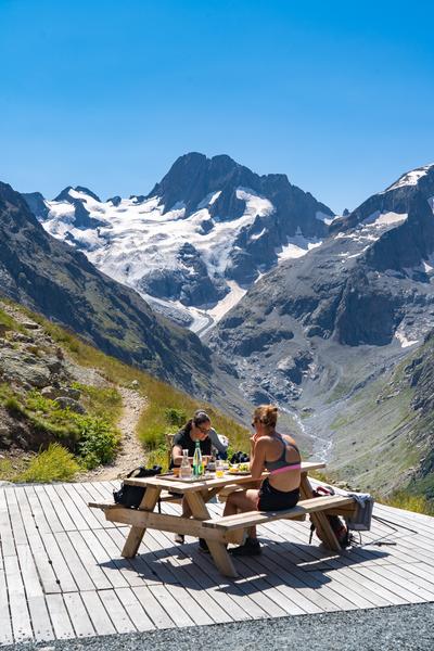
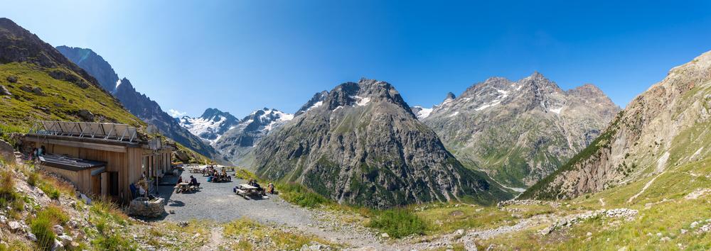
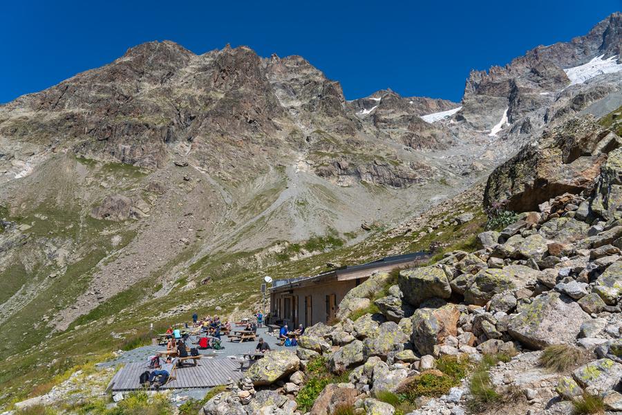
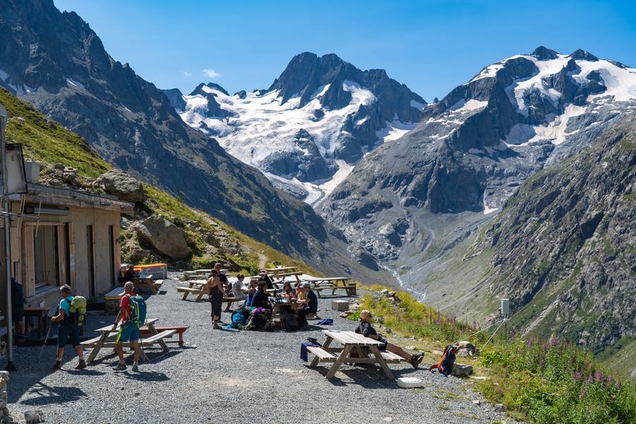
As you leave the forest, the view of the Pilatte glacier, source of the Vénéon, and the Écrins mountain range rewards you for your efforts. The alpine meadow, and then the refuge quickly become part of the landscape, with its terrace stretching out its arms to you.
No physical difficulty, just a little stamina, but with a setting like this there's no shortage of motivation.
"YOU'RE HIKING IN THE HEART OF THE ECRINS NATIONAL PARK
The Écrins massif is an exceptional area, open to all, with a rare natural, cultural and landscape heritage. To protect these treasures, the heart of the park is marked with blue-white-red painted flags, where regulations must be respected. Please take note of them when planning your hike to preserve this collective asset on the ecrins-parcnational.fr website."
TO SEE ON THE ROUTE:
Rhododendrons, gentians and many other mountain flowers can be seen in the alpine meadows. Chamois and marmots are often seen near the refuge.
L'Aillefroide, les Rouies
GOOD TO KNOW:
The Refuge de Temple Ecrins is the starting point for a number of challenging routes, including the Traversée des Ecrins, Pic Coolidge...Good plans : The refuge is guarded from June to September, Don't forget to book.Admission fee : Free access.Opening : From 15/05 to 31/10 daily. Subject to favorable snow and weather conditions.
Departure: La Bérarde-Combe Noire
Difference in altitude: 825m
Duration: 3 h outward journey and 2 h 45 return journey
Distance: 16 km
Level: Difficult hike
ITINERARY:
From the shuttle bus stop follow the road to La Bérarde, take the track on your right then cross the footbridge. Follow the path for about 500 m, then turn around and you can see the Meije, the Grand Pic and the Glacier Carré. The 45-minute climb up to the Plan du Carrelet will give you a good workout.
Then begin the ascent to the Refuge de Temple Ecrins. Leave the main path and take the path that rises to the left at the intersection of the Pilatte and Temple Ecrins valleys. Progress through a forest of hooked pines, where the shape of some of the trunks says a lot about the harshness of the climate!
As you leave the forest, the view of the Pilatte glacier, source of the Vénéon, and the Écrins mountain range rewards you for your efforts. The alpine meadow, and then the refuge quickly become part of the landscape, with its terrace stretching out its arms to you.
No physical difficulty, just a little stamina, but with a setting like this there's no shortage of motivation.
"YOU'RE HIKING IN THE HEART OF THE ECRINS NATIONAL PARK
The Écrins massif is an exceptional area, open to all, with a rare natural, cultural and landscape heritage. To protect these treasures, the heart of the park is marked with blue-white-red painted flags, where regulations must be respected. Please take note of them when planning your hike to preserve this collective asset on the ecrins-parcnational.fr website."
TO SEE ON THE ROUTE:
Rhododendrons, gentians and many other mountain flowers can be seen in the alpine meadows. Chamois and marmots are often seen near the refuge.
L'Aillefroide, les Rouies
GOOD TO KNOW:
The Refuge de Temple Ecrins is the starting point for a number of challenging routes, including the Traversée des Ecrins, Pic Coolidge...Good plans : The refuge is guarded from June to September, Don't forget to book.Admission fee : Free access.Opening : From 15/05 to 31/10 daily. Subject to favorable snow and weather conditions.
Area : Oisans
Report a problem
Features of the application :
- Location and orientation on detailed maps thanks to the GPS of your smartphone
- Description of routes and points of interest on the route
- Photo gallery by route
- Detailed elevation profile
- Route tracking alert to warn you if you stray from the route
- Send predefined messages by SMS to your contacts
- Emergency module: trigger a call or send an emergency SMS in case of problem
- Agenda: access to events organized in the department
- News: find in the application the latest news on the web portal
- Adding achievements
- Add reports in case of problems encountered on the routes
- Share on social networks
Add your time and share your feelings
Services nearby

Tourist office of La Bérarde
Saint-Christophe-en-Oisans - La Bérarde

Chalet Alpin de la Bérarde
Saint-Christophe-en-Oisans - La Bérarde
Mountain hut le Soreiller
Saint-Christophe-en-Oisans - La Bérarde
Refuge du Châtelleret
Saint-Christophe-en-Oisans - La Bérarde
Hut of Temple Ecrins
Saint-Christophe-en-Oisans - La Bérarde


Follow us on
the digital trails
the digital trails


![]()
The Isère Outdoor application was created
by the Département de l'Isère
Infos & contact
Conseil départemental de l'Isère
7 rue Fantin Latour
CS 41096
38 022 Grenoble cedex 1
Tel. 04 76 00 38 38
 Isère Outdoor - Parcours - Refuge de Temple Écrins-trekking from La Bérarde
Hello, world! This is a toast message.
Isère Outdoor - Parcours - Refuge de Temple Écrins-trekking from La Bérarde
Hello, world! This is a toast message.
Isère Outdoor - Parcours - Refuge de Temple Écrins-trekking from La Bérarde
Hello, world! This is a toast message.


OK
Annuler