De la vallée de l’Isère à l’aiguille de Chalais
Add to my favorites

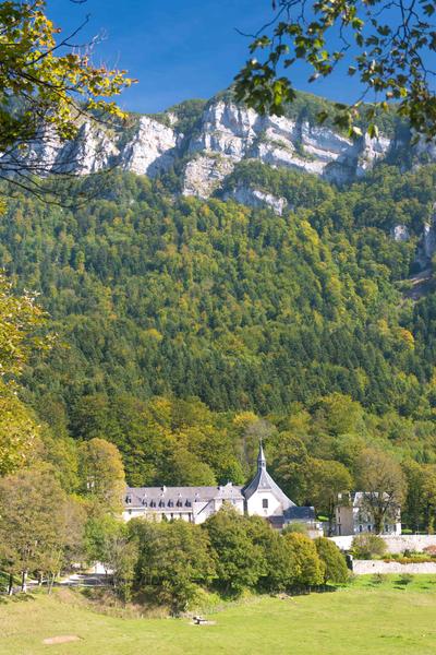
Depuis Voreppe gare, embarquez pour une randonnée sportive jusqu’au site de Chalais, où se dresse un magnifique couvent, typique de l’héritage des chartreux. Sous-bois ombragés, clairières et panoramas sur la vallée vous accompagnent jusqu’à l’arrivée.
The characteristics of the route.

Voreppe (38)
- Distance 18.28 km
- Elevation gain 1050 m
- Elevation lost 1050 m
- Min. elevation 195 m
- Max. elevation. 1046 m
- Duration (depending on pace) 6h47
- Marking Yes
Equipments : Parking nearby, Admission fee : Free access.Opening : All year round daily.
Area : Pays Voironnais
Report a problem
Website De la vallée de l’Isère à l’aiguille de Chalais Features of the application :
- Location and orientation on detailed maps thanks to the GPS of your smartphone
- Description of routes and points of interest on the route
- Photo gallery by route
- Detailed elevation profile
- Route tracking alert to warn you if you stray from the route
- Send predefined messages by SMS to your contacts
- Emergency module: trigger a call or send an emergency SMS in case of problem
- Agenda: access to events organized in the department
- News: find in the application the latest news on the web portal
- Adding achievements
- Add reports in case of problems encountered on the routes
- Share on social networks
Add your time and share your feelings
Services nearby

Pays Voironnais Tourist Office, Voiron information office
Voiron

Mainssieux Museum
Voiron
Sassenage Tourist Information Center
Sassenage

Refuge de Gève
Autrans-Méaudre en Vercors

Col de Porte
Sarcenas


Information updated on 2026-05-04 by Office de Tourisme du Pays Voironnais


Follow us on
the digital trails
the digital trails


![]()
The Isère Outdoor application was created
by the Département de l'Isère
Infos & contact
Conseil départemental de l'Isère
7 rue Fantin Latour
CS 41096
38 022 Grenoble cedex 1
Tel. 04 76 00 38 38
 Isère Outdoor - Parcours - De la vallée de l’Isère à l’aiguille de Chalais
Hello, world! This is a toast message.
Isère Outdoor - Parcours - De la vallée de l’Isère à l’aiguille de Chalais
Hello, world! This is a toast message.
Isère Outdoor - Parcours - De la vallée de l’Isère à l’aiguille de Chalais
Hello, world! This is a toast message.


OK
Annuler