Refuge du Soreiller - hike from Les Étages
Add to my favorites

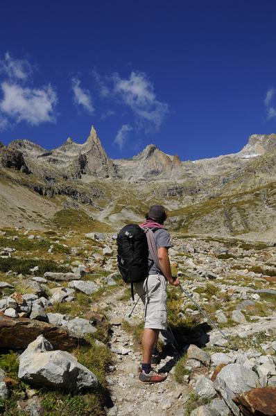
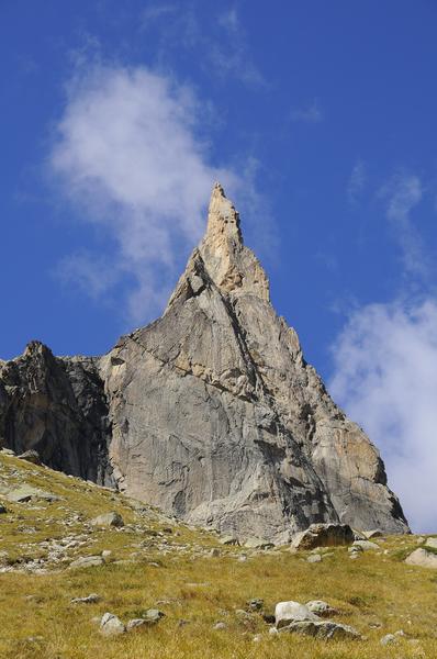
A fine hike up the Soreiller valley to see the extraordinary Aiguille Dibona and visit the mountain hut nestling at the foot of the needle. The hut terrace is the perfect place for watching mountaineers on the rock face.
The characteristics of the route.

Saint-Christophe-en-Oisans (38)
- Distance 10.57 km
- Elevation gain 1150 m
- Elevation lost 1150 m
- Min. elevation 1593 m
- Max. elevation. 2709 m
- Duration (depending on pace) 4h45
- Marking Yes
TECHNICAL INFORMATION
Start: Parking des Étages
Height difference: 1139 m
Duration: 2 h 45 outward and 2 h return
Distance: 9 km
Level :
difficult hike
MAP AND TOPO
IGN TOP 25 n°3336 ET
OBP n° 5 (Oisans au Bout des Pieds) : 542
ITINERARY
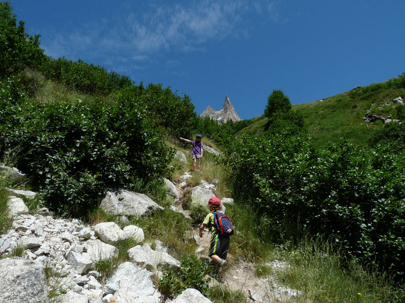
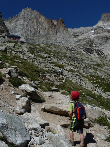
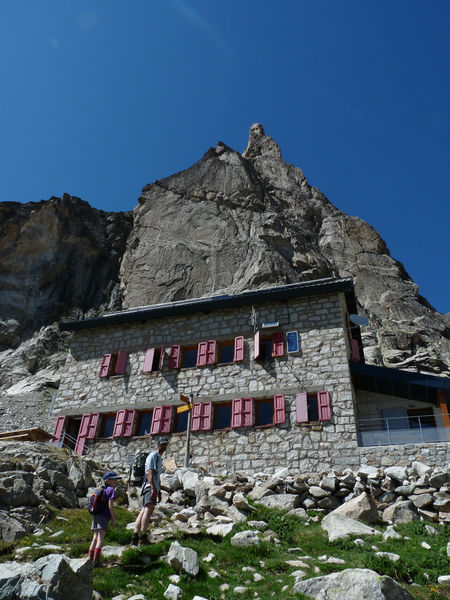
The classic Combe d'Amont trail begins at the entrance to the hamlet of Les Étages. After a winding climb through rhododendrons, it joins the combe d'amont and crosses its torrent via a footbridge. The extraordinary Aiguille Dibona (3130 m) rises up in the middle, with the refuge nestling at its foot. The false flat that follows the exit from the combe is a good place to stop before starting the last steep switchbacks to the refuge, with its red shutters already in view. The view from the refuge is splendid over the entire southern massif.
Dogs on leashes are allowed on the trail, but please be vigilant, as the valley is home to flocks of sheep in summer.
THINGS TO SEE ON THE WAY
The Aiguille de la Dibona is a climber's paradise. It owes its name to mountaineer Angelo Dibona, author of numerous difficult routes from the 1880s onwards.
NOTES
- Beware of snow at the start of the season.
- The refuge is the starting point for numerous climbing routes. The most famous peak in the Soreiller cirque is the Aiguille Dibona. Just 10 minutes from the refuge, you'll find a host of great climbing routes on excellent granite.Equipments : Car park, Admission fee : Free access.Opening : From 15/05 to 31/10 daily. Subject to favorable snow and weather conditions.
Start: Parking des Étages
Height difference: 1139 m
Duration: 2 h 45 outward and 2 h return
Distance: 9 km
Level :
difficult hike
MAP AND TOPO
IGN TOP 25 n°3336 ET
OBP n° 5 (Oisans au Bout des Pieds) : 542
ITINERARY
The classic Combe d'Amont trail begins at the entrance to the hamlet of Les Étages. After a winding climb through rhododendrons, it joins the combe d'amont and crosses its torrent via a footbridge. The extraordinary Aiguille Dibona (3130 m) rises up in the middle, with the refuge nestling at its foot. The false flat that follows the exit from the combe is a good place to stop before starting the last steep switchbacks to the refuge, with its red shutters already in view. The view from the refuge is splendid over the entire southern massif.
Dogs on leashes are allowed on the trail, but please be vigilant, as the valley is home to flocks of sheep in summer.
THINGS TO SEE ON THE WAY
The Aiguille de la Dibona is a climber's paradise. It owes its name to mountaineer Angelo Dibona, author of numerous difficult routes from the 1880s onwards.
NOTES
- Beware of snow at the start of the season.
- The refuge is the starting point for numerous climbing routes. The most famous peak in the Soreiller cirque is the Aiguille Dibona. Just 10 minutes from the refuge, you'll find a host of great climbing routes on excellent granite.Equipments : Car park, Admission fee : Free access.Opening : From 15/05 to 31/10 daily. Subject to favorable snow and weather conditions.
Area : Oisans
Report a problem
Features of the application :
- Location and orientation on detailed maps thanks to the GPS of your smartphone
- Description of routes and points of interest on the route
- Photo gallery by route
- Detailed elevation profile
- Route tracking alert to warn you if you stray from the route
- Send predefined messages by SMS to your contacts
- Emergency module: trigger a call or send an emergency SMS in case of problem
- Agenda: access to events organized in the department
- News: find in the application the latest news on the web portal
- Adding achievements
- Add reports in case of problems encountered on the routes
- Share on social networks
Add your time and share your feelings
Services nearby

Tourist office of La Bérarde
Saint-Christophe-en-Oisans - La Bérarde

Chalet Alpin de la Bérarde
Saint-Christophe-en-Oisans - La Bérarde
Mountain hut le Soreiller
Saint-Christophe-en-Oisans - La Bérarde
Refuge de la Selle
Saint-Christophe-en-Oisans - La Bérarde
Refuge du Châtelleret
Saint-Christophe-en-Oisans - La Bérarde


Follow us on
the digital trails
the digital trails


![]()
The Isère Outdoor application was created
by the Département de l'Isère
Infos & contact
Conseil départemental de l'Isère
7 rue Fantin Latour
CS 41096
38 022 Grenoble cedex 1
Tel. 04 76 00 38 38
 Isère Outdoor - Parcours - Refuge du Soreiller - hike from Les Étages
Hello, world! This is a toast message.
Isère Outdoor - Parcours - Refuge du Soreiller - hike from Les Étages
Hello, world! This is a toast message.
Isère Outdoor - Parcours - Refuge du Soreiller - hike from Les Étages
Hello, world! This is a toast message.


OK
Annuler