Lakes of the Plateau d'Emparis - hike from Les Aymes (Mizoën)
Add to my favorites

Caution! Zone of vigilance near the route
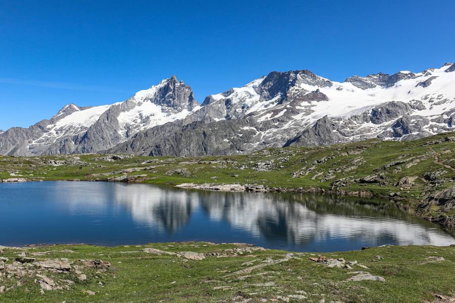
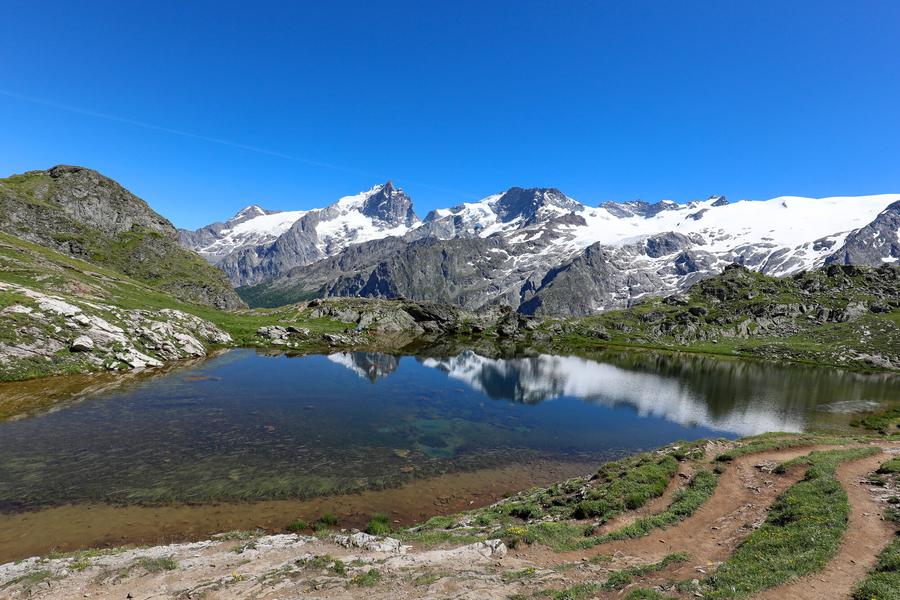
Situated on the edge of the Ecrins National Park, the plateau offers magnificent views of the Meije and surrounding glaciers. It's a paradise for hikers, lovers of wide open spaces and picnic enthusiasts!
The characteristics of the route.

Mizoën (38)
- Distance 22.9 km
- Elevation gain 1430 m
- Elevation lost 1430 m
- Min. elevation 1271 m
- Max. elevation. 2454 m
- Duration (depending on pace) 8h
- Marking Yes
TECHNICAL INFORMATION
Start: Parking des Aymes (Mizoën). Altitude: 1,300 m.
Difference in altitude: 1377 m
Round trip time: 8 h 30
Return distance : 20.6 km
Level: Very difficult
Caution: Balcony trail on certain sections. It may present difficulties for people prone to vertigo.
MAP AND TOPO
- IGN TOP 25 map no. 3335 ET (Bourg d'Oisans - Alpe d'Huez)
- OBP map and topo n°3 (Oisans au Bout des Pieds): trails n°343 and n°416 (in part) on the outward journey, then n°359 and again n°343 on the return. On sale at Oisans Tourisme tourist offices.
ITINERARY
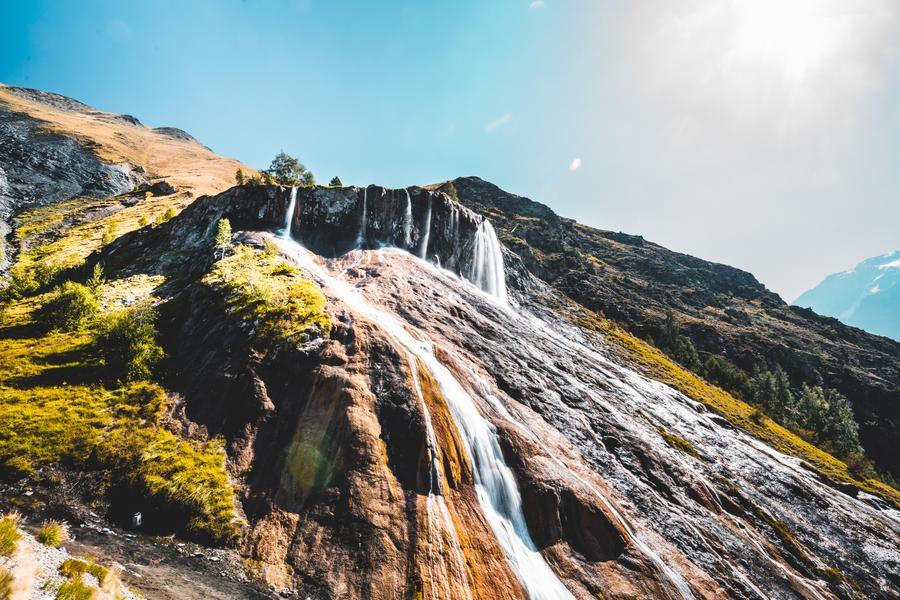
Take the path that starts at the end of the Aymes parking lot, and continue straight on to the hamlet of Les Clots, following the GR markings (red and white). The path is initially wide and shady, but after a few minutes becomes narrow, balcony-like and open. This part of the trail is not very steep. After this, you can make a detour to Lac Lovitel and its discovery trail leading to an orientation table. Shortly afterwards, you'll reach the refuge des Clots, with its panoramic view of the Meije and the Fontaine Pétrifiante waterfall. To reach the plateau, take the path towards the waterfall. From this point on, the path becomes steeper (approx. 600 m ascent over 1.6 km). Stay on the path and follow the GR markings until you reach the plateau, where the trail continues to climb, but less steeply. At the Fay and Mouterres refuges, the trail gradually descends along the Rif Tort towards the center of the Emparis plateau. Once you reach the center of the plateau, you'll have a 360-degree view of the plateau's Alpine pastures, with their air of Mongolian steppes. At the center of the plateau, take the right-hand track (GR54) towards the Col du Souchet (2365 m). At the pass, leave the GR54 (which leads down to Le Chazelet) and turn right into the grassy Combe leading to the edge of Lac Lérié. Continue right over the lake to reach Lac Noir. From here, an exceptional panorama of the Meije and Râteau peaks awaits you, with the Rousses massif to the north. From the lake, follow the path north to the center of the plateau. Follow the same route down to Les Aymes.
THINGS TO SEE ALONG THE WAY
- Petrifying Fountain waterfall
- Refuges du Fay and des Mouterres
- Rif Tort marshes
- Lac Noir, Lac Lérié, Lac Cristallin
- Alpine pastures
- Panoramic views of the Meije and Écrins mountains
NEARBY ATTRACTIONS
- Village of MizoënMarking : Yellow PDIPR sign. GR markings (red and white)Admission fee : Free access.Opening : From 01/01 to 31/10 daily. Subject to favorable snow and weather conditions.Warning : The site is subject to heavy traffic in July and August. We invite you to discover our nearby suggestion to take full advantage of our territory. As this itinerary is potentially subject to severe damage due to major meteorological events, and its viability may be uncertain, please enquire before embarking on it.
Start: Parking des Aymes (Mizoën). Altitude: 1,300 m.
Difference in altitude: 1377 m
Round trip time: 8 h 30
Return distance : 20.6 km
Level: Very difficult
Caution: Balcony trail on certain sections. It may present difficulties for people prone to vertigo.
MAP AND TOPO
- IGN TOP 25 map no. 3335 ET (Bourg d'Oisans - Alpe d'Huez)
- OBP map and topo n°3 (Oisans au Bout des Pieds): trails n°343 and n°416 (in part) on the outward journey, then n°359 and again n°343 on the return. On sale at Oisans Tourisme tourist offices.
ITINERARY
Take the path that starts at the end of the Aymes parking lot, and continue straight on to the hamlet of Les Clots, following the GR markings (red and white). The path is initially wide and shady, but after a few minutes becomes narrow, balcony-like and open. This part of the trail is not very steep. After this, you can make a detour to Lac Lovitel and its discovery trail leading to an orientation table. Shortly afterwards, you'll reach the refuge des Clots, with its panoramic view of the Meije and the Fontaine Pétrifiante waterfall. To reach the plateau, take the path towards the waterfall. From this point on, the path becomes steeper (approx. 600 m ascent over 1.6 km). Stay on the path and follow the GR markings until you reach the plateau, where the trail continues to climb, but less steeply. At the Fay and Mouterres refuges, the trail gradually descends along the Rif Tort towards the center of the Emparis plateau. Once you reach the center of the plateau, you'll have a 360-degree view of the plateau's Alpine pastures, with their air of Mongolian steppes. At the center of the plateau, take the right-hand track (GR54) towards the Col du Souchet (2365 m). At the pass, leave the GR54 (which leads down to Le Chazelet) and turn right into the grassy Combe leading to the edge of Lac Lérié. Continue right over the lake to reach Lac Noir. From here, an exceptional panorama of the Meije and Râteau peaks awaits you, with the Rousses massif to the north. From the lake, follow the path north to the center of the plateau. Follow the same route down to Les Aymes.
THINGS TO SEE ALONG THE WAY
- Petrifying Fountain waterfall
- Refuges du Fay and des Mouterres
- Rif Tort marshes
- Lac Noir, Lac Lérié, Lac Cristallin
- Alpine pastures
- Panoramic views of the Meije and Écrins mountains
NEARBY ATTRACTIONS
- Village of MizoënMarking : Yellow PDIPR sign. GR markings (red and white)Admission fee : Free access.Opening : From 01/01 to 31/10 daily. Subject to favorable snow and weather conditions.Warning : The site is subject to heavy traffic in July and August. We invite you to discover our nearby suggestion to take full advantage of our territory. As this itinerary is potentially subject to severe damage due to major meteorological events, and its viability may be uncertain, please enquire before embarking on it.
Area : Oisans
Report a problem
Pdf file Pdf file Features of the application :
- Location and orientation on detailed maps thanks to the GPS of your smartphone
- Description of routes and points of interest on the route
- Photo gallery by route
- Detailed elevation profile
- Route tracking alert to warn you if you stray from the route
- Send predefined messages by SMS to your contacts
- Emergency module: trigger a call or send an emergency SMS in case of problem
- Agenda: access to events organized in the department
- News: find in the application the latest news on the web portal
- Adding achievements
- Add reports in case of problems encountered on the routes
- Share on social networks
Add your time and share your feelings
Services nearby

Refuge Les Clôts
Mizoën

Chasal Lento Museum
Les Deux Alpes

Tourist office of le Ferrand
Besse-en-Oisans
Pastures Museum
Besse-en-Oisans
Exhibition area - Maison de la Montagne
Les Deux Alpes


Information updated on 2026-03-12 by Isère Attractivité


Follow us on
the digital trails
the digital trails


![]()
The Isère Outdoor application was created
by the Département de l'Isère
Infos & contact
Conseil départemental de l'Isère
7 rue Fantin Latour
CS 41096
38 022 Grenoble cedex 1
Tel. 04 76 00 38 38
 Isère Outdoor - Parcours - Lakes of the Plateau d'Emparis - hike from Les Aymes (Mizoën)
Hello, world! This is a toast message.
Isère Outdoor - Parcours - Lakes of the Plateau d'Emparis - hike from Les Aymes (Mizoën)
Hello, world! This is a toast message.
Isère Outdoor - Parcours - Lakes of the Plateau d'Emparis - hike from Les Aymes (Mizoën)
Hello, world! This is a toast message.


OK
Annuler