Hiking - Refuge et vallon de la Lavey
Add to my favorites

Caution! Zone of vigilance near the route
Lavey Rive Droite - du 15/06/2026 au 15/10/2026 In progress
Le Puy - du 11/06/2026 au 20/10/2026 In progress
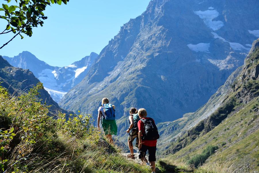
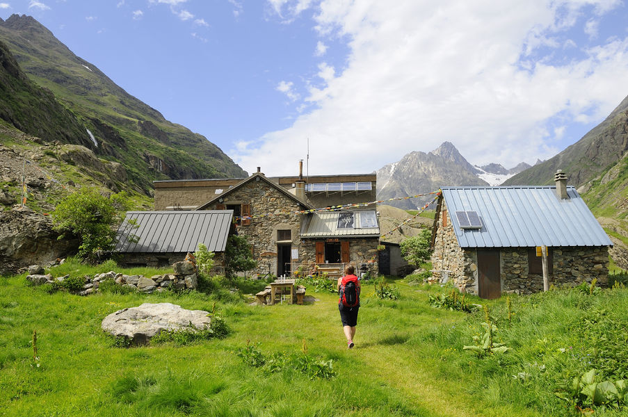
Family hike along the Muande stream. Please note that the Lavey refuge is closed until spring 2027.
The characteristics of the route.

Saint-Christophe-en-Oisans (38)
- Distance 10.2 km
- Elevation gain 570 m
- Elevation lost 570 m
- Min. elevation 1421 m
- Max. elevation. 1804 m
- Duration (depending on pace) 4h45
- Marking Yes
TECHNICAL INFORMATION
Start: Champhorent parking lot
Height difference: 400 m
Duration: 2 h 30 outward and 2 h 15 return
Distance: 9.4 km
Level :
Medium hike
MAP AND TOPO
IGN TOP 25 n°3336 ET
OBP n° 5 (Oisans au Bout des Pieds) trail 531-539
ITINERARY
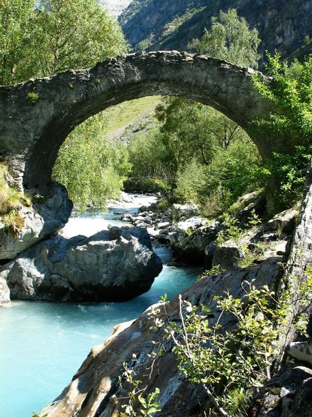
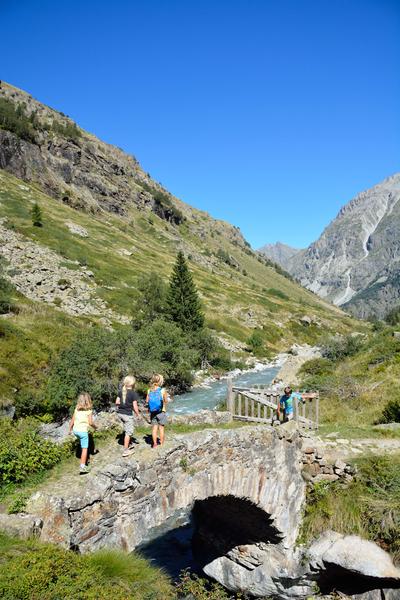
The parking lot is at the entrance to the hamlet of Champhorent (3 km after St Christophe en Oisans), below the road. Take the footpath at the end of the parking lot down to the Vénéon torrent and its magnificent Pont des Rajas. Cross the pretty stone bridge and climb towards the Rajas houses. Continue uphill to enter the Vallon de la Muande and follow the torrent on the right bank, then on the left bank after a second stone bridge. At the shepherd's hut, cross the gently sloping slabs to reach the refuge hidden behind this small glacial lock.
THE PARC DES ECRINS, A FRAGILE NATURAL ENVIRONMENT TO PROTECT
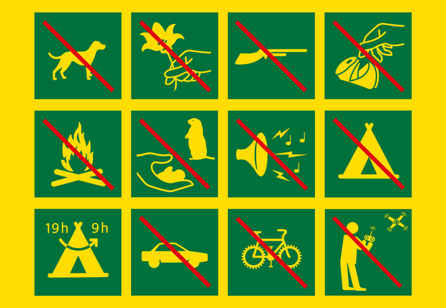
When hiking in the Parc des Ecrins, you must respect the regulations that allow you to enjoy this exceptional natural area: do not leave the trails, dogs are forbidden even on a leash, do not pick flowers or collect fossils, minerals, animals..., do not throw anything on the ground (bring your own garbage). Nature thanks you!
To see along the way
- the Pont des Rajas
- Lavey refuge
- L'olan, les RouiesMarking : Yellow PDIPR signsAdmission fee : Free access.Opening : From 15/05 to 31/10 daily. Subject to favorable snow and weather conditions.
Start: Champhorent parking lot
Height difference: 400 m
Duration: 2 h 30 outward and 2 h 15 return
Distance: 9.4 km
Level :
Medium hike
MAP AND TOPO
IGN TOP 25 n°3336 ET
OBP n° 5 (Oisans au Bout des Pieds) trail 531-539
ITINERARY
The parking lot is at the entrance to the hamlet of Champhorent (3 km after St Christophe en Oisans), below the road. Take the footpath at the end of the parking lot down to the Vénéon torrent and its magnificent Pont des Rajas. Cross the pretty stone bridge and climb towards the Rajas houses. Continue uphill to enter the Vallon de la Muande and follow the torrent on the right bank, then on the left bank after a second stone bridge. At the shepherd's hut, cross the gently sloping slabs to reach the refuge hidden behind this small glacial lock.
THE PARC DES ECRINS, A FRAGILE NATURAL ENVIRONMENT TO PROTECT
When hiking in the Parc des Ecrins, you must respect the regulations that allow you to enjoy this exceptional natural area: do not leave the trails, dogs are forbidden even on a leash, do not pick flowers or collect fossils, minerals, animals..., do not throw anything on the ground (bring your own garbage). Nature thanks you!
To see along the way
- the Pont des Rajas
- Lavey refuge
- L'olan, les RouiesMarking : Yellow PDIPR signsAdmission fee : Free access.Opening : From 15/05 to 31/10 daily. Subject to favorable snow and weather conditions.
Area : Oisans
Report a problem
Features of the application :
- Location and orientation on detailed maps thanks to the GPS of your smartphone
- Description of routes and points of interest on the route
- Photo gallery by route
- Detailed elevation profile
- Route tracking alert to warn you if you stray from the route
- Send predefined messages by SMS to your contacts
- Emergency module: trigger a call or send an emergency SMS in case of problem
- Agenda: access to events organized in the department
- News: find in the application the latest news on the web portal
- Adding achievements
- Add reports in case of problems encountered on the routes
- Share on social networks
Add your time and share your feelings
Services nearby

Mountain hut l'Alpe du Pin
Saint-Christophe-en-Oisans - La Bérarde

Tourist office of St-Christophe-en-Oisans - La Bérarde
Saint-Christophe-en-Oisans - La Bérarde

Museum " mountaineering Memory"
Saint-Christophe-en-Oisans - La Bérarde
La Lavey mountain hut
Saint-Christophe-en-Oisans - La Bérarde
Mountain hut le Soreiller
Saint-Christophe-en-Oisans - La Bérarde


Follow us on
the digital trails
the digital trails


![]()
The Isère Outdoor application was created
by the Département de l'Isère
Infos & contact
Conseil départemental de l'Isère
7 rue Fantin Latour
CS 41096
38 022 Grenoble cedex 1
Tel. 04 76 00 38 38
 Isère Outdoor - Parcours - Hiking - Refuge et vallon de la Lavey
Hello, world! This is a toast message.
Isère Outdoor - Parcours - Hiking - Refuge et vallon de la Lavey
Hello, world! This is a toast message.
Isère Outdoor - Parcours - Hiking - Refuge et vallon de la Lavey
Hello, world! This is a toast message.


OK
Annuler