Car-free hike- 2 days / 1 night - Lakes and Refuge des 7 Laux
Add to my favorites

Caution! Zone of vigilance near the route
Les 7 Laux - du 20/06/2026 au 20/09/2026 In progress
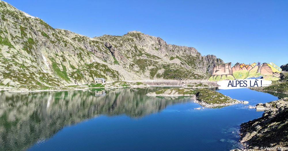
The Plateau des 7 Laux with its many lakes is a wonderful reward after the efforts of the climb. Overnight stays can be made at the 7 Laux refuge (reservation required), in an unguarded hut or in a bivouac. Itinerary with public transport proposed by Alpes Là.
The characteristics of the route.

Le Haut-Bréda (38)
- Distance 12.5 km
- Elevation gain 1090 m
- Elevation lost 1090 m
- Min. elevation 1086 m
- Max. elevation. 2138 m
- Duration (depending on pace) 3h45
- Marking Yes
Start: Fond de France, Haut-Bréda (1086 m) - 1 h 35 (2.6 km, D+ 458 m)
From the Gite l'Essentiel, take the south-west path to France Barral. Cross the Pont de la Sauge and continue east along the forest track: after 300 m, at Côte Rosset, join the GR 738/Tour du Pays d'Allevard® path.
Follow the GR738® upwards. It first rises in the forest to the southeast, then steepens to follow the ridge to the southwest.
Arrive at a crossroads called Les 2 Ruisseaux.
1) Les 2 Ruisseaux (1563 m) - 1 h 45 (2.5 km, D+ 536 m)
Ignore the path leading to the Chalet du Gleyzin (alternative route proposed for the return) and continue along the GR738®, which is less exposed to the morning sun. The path soon leaves the forest and climbs up into the valley, crossing the Bréda stream several times, ending with a steeper section above a gorge. Exit onto the Plateau des 7 Laux and
continue on the GR® to Lac Noir (heading south-west).
2) Lac Noir (2097 m) - 20 min (1.0 km, D+ 48 m, D- 12 m)
Continue along the GR® to Lac Carré and Lac Cottepens. The 7 Laux refuge is located at the dam separating them, on a peninsula reached by a good footbridge.
3) Refuge des 7 Laux (2138 m) - 2 h 05 (6.1 km, D+ 14 m,
D- 1065 m)
You can return :
- either by the same route
- or by taking the alternative route via the Chalet du Gleyzin: back at Lac Noir, follow the signposted path (heading north-west). The path includes a steeper passage in the rocks.
Return to Fond de France, Haut-Bréda (1086 m)Marking : This route is marked with yellow signs and yellow paint (PR) and red and white paint (GR).Delicate passages : Be careful not to slip when crossing rivers. The path is sometimes a little steep, with rocks: take care when descending.Admission fee : Free access. Guarded refuge (fee payable).Opening : From 14/06 to 13/09 daily.Warning : A car-free hike where you can take the bus to and from the site. Make sure you know the time and day of traffic before you leave.
From the Gite l'Essentiel, take the south-west path to France Barral. Cross the Pont de la Sauge and continue east along the forest track: after 300 m, at Côte Rosset, join the GR 738/Tour du Pays d'Allevard® path.
Follow the GR738® upwards. It first rises in the forest to the southeast, then steepens to follow the ridge to the southwest.
Arrive at a crossroads called Les 2 Ruisseaux.
1) Les 2 Ruisseaux (1563 m) - 1 h 45 (2.5 km, D+ 536 m)
Ignore the path leading to the Chalet du Gleyzin (alternative route proposed for the return) and continue along the GR738®, which is less exposed to the morning sun. The path soon leaves the forest and climbs up into the valley, crossing the Bréda stream several times, ending with a steeper section above a gorge. Exit onto the Plateau des 7 Laux and
continue on the GR® to Lac Noir (heading south-west).
2) Lac Noir (2097 m) - 20 min (1.0 km, D+ 48 m, D- 12 m)
Continue along the GR® to Lac Carré and Lac Cottepens. The 7 Laux refuge is located at the dam separating them, on a peninsula reached by a good footbridge.
3) Refuge des 7 Laux (2138 m) - 2 h 05 (6.1 km, D+ 14 m,
D- 1065 m)
You can return :
- either by the same route
- or by taking the alternative route via the Chalet du Gleyzin: back at Lac Noir, follow the signposted path (heading north-west). The path includes a steeper passage in the rocks.
Return to Fond de France, Haut-Bréda (1086 m)Marking : This route is marked with yellow signs and yellow paint (PR) and red and white paint (GR).Delicate passages : Be careful not to slip when crossing rivers. The path is sometimes a little steep, with rocks: take care when descending.Admission fee : Free access. Guarded refuge (fee payable).Opening : From 14/06 to 13/09 daily.Warning : A car-free hike where you can take the bus to and from the site. Make sure you know the time and day of traffic before you leave.
Area : Grésivaudan
Report a problem
Website Pdf file Features of the application :
- Location and orientation on detailed maps thanks to the GPS of your smartphone
- Description of routes and points of interest on the route
- Photo gallery by route
- Detailed elevation profile
- Route tracking alert to warn you if you stray from the route
- Send predefined messages by SMS to your contacts
- Emergency module: trigger a call or send an emergency SMS in case of problem
- Agenda: access to events organized in the department
- News: find in the application the latest news on the web portal
- Adding achievements
- Add reports in case of problems encountered on the routes
- Share on social networks
Add your time and share your feelings
Services nearby

Le Pleynet Les 7 Laux Tourist Information Office
Les Sept Laux Le Pleynet

Les 7 Laux Refuge
Le Haut-Bréda
Combe Madame mountain pasture gîte
Le Haut-Bréda
Crêt du Poulet refuge
Crêts en Belledonne
Refuge de l'Oule
Le Haut-Bréda


Information updated on 2026-04-07 by Isère Attractivité


Follow us on
the digital trails
the digital trails





The Isère Outdoor application was created
by the Département de l'Isère
Infos & contact
Conseil départemental de l'Isère
7 rue Fantin Latour
CS 41096
38 022 Grenoble cedex 1
Tel. 04 76 00 38 38
 Isère Outdoor - Parcours - Car-free hike- 2 days / 1 night - Lakes and Refuge des 7 Laux
Hello, world! This is a toast message.
Isère Outdoor - Parcours - Car-free hike- 2 days / 1 night - Lakes and Refuge des 7 Laux
Hello, world! This is a toast message.
Isère Outdoor - Parcours - Car-free hike- 2 days / 1 night - Lakes and Refuge des 7 Laux
Hello, world! This is a toast message.


OK
Annuler