The Saint-Ours chapel and the Echaillon viewpoint
Add to my favorites

Caution! Zone of vigilance near the route
Faucon pèlerin - du 01/02/2026 au 30/06/2026 In progress
Grand-duc d'Europe - du 01/01/2026 au 31/08/2026 In progress
Of the 12 communes nestled at the foot of the Vercors, Veurey-Voroize is the most northerly. The walk proposed here leads to the Saint-Ours chapel, next to the Echaillon viewpoint.
The characteristics of the route.

Veurey-Voroize (38)
- Distance 4.6 km
- Elevation gain 360 m
- Elevation lost 360 m
- Min. elevation 271 m
- Max. elevation. 617 m
- Duration (depending on pace) 2h30
- Marking Yes
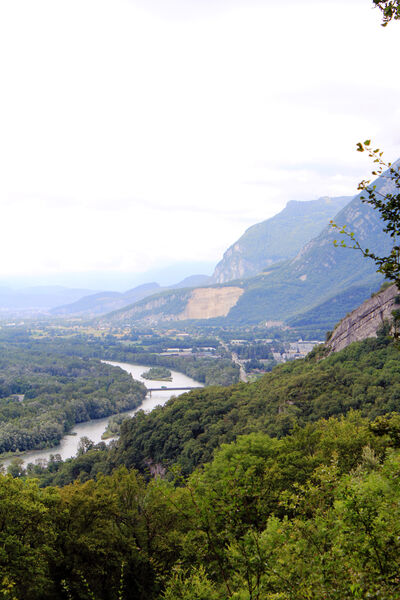
Marking : Yellow markings (Petite Randonnée)Equipments : Car park, Delicate passages : No difficulty but be careful at the chapel and the BelvedereAdmission fee : Free access.Opening : All year round.Step by step description : Departure is either from Veurey, or directly from Petit Port, 2 km after the village of Veurey. In both cases, follow the signs for Saint Ours. Above Petit Port, your soles soon tread the shiny slabs of a Roman road, some sections of which are quite well preserved. After 15 to 20 minutes of fairly steep climbing, at 355 m, turn left towards the chapel and the belvedere. The characteristic vegetation of hilly limestone slopes accompanies the hiker: mainly fragon, boxwood, holly and downy oak. After 30 minutes, at an altitude of 480 m, the path comes alongside the arrival station of an old cable car. From the early 20th century until the 1980s, it was used to transport wood, and later to supply the Saint Ours farm. After another 30-minute ascent, the landscape opens up as we reach the ridge, and there's a change of scenery! Perched on the northern edge of the Vercors massif, at an altitude of 620 m, the hiker overlooks the exit of the Cluse de Voreppe, discovering new horizons over the Isère valley, the Pays Voironnais and the Sud Grésivaudan. Today, it's hard to believe that the Roman road that can still be seen below was a compulsory passage on the Valence-Grenoble route, as the cyclical flooding of the Isère made the valley impassable. Allow 45 minutes for the descent. At the cable-car station, turn left to vary the route. Join the path leading up to Les Combes, at 355 m, to reach Petit Port in just a few minutes.
SEE AND KNOW:The famous Echaillon stone was shipped from Petit Port. It can be seen, for example, at the Natural History Museum (colonnades overlooking the Jardin des Plantes, as well as elements of the facade). From Roman times to the 17th century, limestone extracted from Echaillon was transported by river. In the 18th century, violent flooding washed out the access road, and the quarry did not resume regular activity until 1848. The quarries closed for good in 1939.
Area : Grenoble-Alpes Métropole
Report a problem
Website Pdf file Features of the application :
- Location and orientation on detailed maps thanks to the GPS of your smartphone
- Description of routes and points of interest on the route
- Photo gallery by route
- Detailed elevation profile
- Route tracking alert to warn you if you stray from the route
- Send predefined messages by SMS to your contacts
- Emergency module: trigger a call or send an emergency SMS in case of problem
- Agenda: access to events organized in the department
- News: find in the application the latest news on the web portal
- Adding achievements
- Add reports in case of problems encountered on the routes
- Share on social networks
aupetits
finished in 02:30:00
The 2021/11/05
En savoir plus
Ajouter votre chrono et partager vos sensations
2021/11/05 02:30:00
aupetits
aupetits
2021/11/05 02:30:00
aupetits
aupetits
Services nearby

Pays Voironnais Tourist Office, Voiron information office
Voiron

Refuge de Gève
Autrans-Méaudre en Vercors

Mainssieux Museum
Voiron
Sassenage Tourist Information Center
Sassenage

La Moliere
Autrans-Méaudre en Vercors


Information updated on 2025-05-06 by Office de Tourisme Grenoble Alpes


Follow us on
the digital trails
the digital trails


![]()
The Isère Outdoor application was created
by the Département de l'Isère
Infos & contact
Conseil départemental de l'Isère
7 rue Fantin Latour
CS 41096
38 022 Grenoble cedex 1
Tel. 04 76 00 38 38
 Isère Outdoor - Parcours - The Saint-Ours chapel and the Echaillon viewpoint
Hello, world! This is a toast message.
Isère Outdoor - Parcours - The Saint-Ours chapel and the Echaillon viewpoint
Hello, world! This is a toast message.
Isère Outdoor - Parcours - The Saint-Ours chapel and the Echaillon viewpoint
Hello, world! This is a toast message.


OK
Annuler