The Three Saints countryside
Add to my favorites


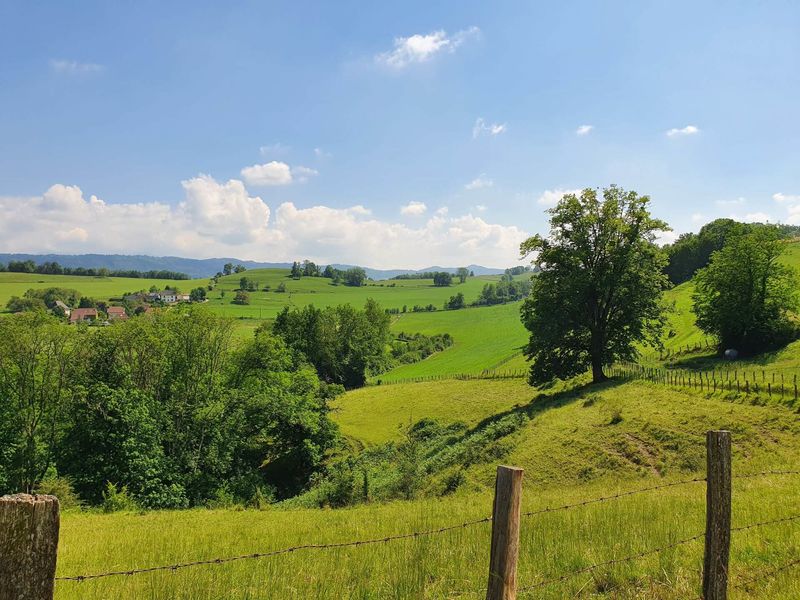
A tour of the Dauphiné countryside, with panoramic views of the Guiers Gorge and the Chartreuse from the Valdaine hills, where cattle farming is still very much alive. Remarkable castles and churches dot the route.
The characteristics of the route.

Saint-Jean-d'Avelanne (38)
- Distance 17.79 km
- Elevation gain 390 m
- Elevation lost 390 m
- Min. elevation 309 m
- Max. elevation. 587 m
- Duration (depending on pace) 5h
- Marking Yes
ROUTE
At the start, notice the beautiful church of Saint-Jean-d'Avelanne with its square tower and exposed stone walls. You'll soon reach the shady Melet path lined with chestnut trees. After the hamlet of La Brancha, the path climbs up into the Valdaine hills.
Once you reach Le Bapt, the landscape opens up to the Chartreuse and Epine mountains. After another climb, look down on the bucolic Ainan valley and the Guiers gorges a little further on your left.
Pass through the hamlet of La Sauge and then follow the meadows where the cows graze. Once in the forest, look out for the Sacré-Coeur site on your left. This statue, erected by parishioners at the end of the 19th century, offers a view over the valley and the Bugey region.
The path along the edge of the forest leads back down to the church, where there is a fresco illustrating Saint Martin giving his cloak to a beggar. The village of Vieux Saint-Jean and the Combe pond brighten up the end of the route.
WAYMARKING AND SIGNPOSTING
From the ST-JEAN D'AVELANNE town hall, follow the yellow signs and the following signposts:
Chemin du Melet > La Brancha > Le Bapt > Crête de la Sauge > La Sauge > Sacré-Coeur > L'Antiquaire > Les Forêts > Sacré-Coeur
La Sauge > Sacré-Coeur > L'Antiquaire > Les Forêts > Le Menou > Return to SAINT-JEAN-D'AVELANNEMarking : From the ST-JEAN D'AVELANNE town hall, follow the yellow signs and the following signposts: Chemin du Melet > La Brancha > Le Bapt > Crête de la Sauge > La Sauge > Sacré-Coeur > L'Antiquaire > Les Forêts > Sacré-Coeur La Sauge > Sacré-Coeur > L'Antiquaire > Les Forêts > Le Menou > Return to SAINT-JEAN-D'AVELANNEEquipments : Public WC, Car park, Admission fee : Free access.Opening : All year round daily.
At the start, notice the beautiful church of Saint-Jean-d'Avelanne with its square tower and exposed stone walls. You'll soon reach the shady Melet path lined with chestnut trees. After the hamlet of La Brancha, the path climbs up into the Valdaine hills.
Once you reach Le Bapt, the landscape opens up to the Chartreuse and Epine mountains. After another climb, look down on the bucolic Ainan valley and the Guiers gorges a little further on your left.
Pass through the hamlet of La Sauge and then follow the meadows where the cows graze. Once in the forest, look out for the Sacré-Coeur site on your left. This statue, erected by parishioners at the end of the 19th century, offers a view over the valley and the Bugey region.
The path along the edge of the forest leads back down to the church, where there is a fresco illustrating Saint Martin giving his cloak to a beggar. The village of Vieux Saint-Jean and the Combe pond brighten up the end of the route.
WAYMARKING AND SIGNPOSTING
From the ST-JEAN D'AVELANNE town hall, follow the yellow signs and the following signposts:
Chemin du Melet > La Brancha > Le Bapt > Crête de la Sauge > La Sauge > Sacré-Coeur > L'Antiquaire > Les Forêts > Sacré-Coeur
La Sauge > Sacré-Coeur > L'Antiquaire > Les Forêts > Le Menou > Return to SAINT-JEAN-D'AVELANNEMarking : From the ST-JEAN D'AVELANNE town hall, follow the yellow signs and the following signposts: Chemin du Melet > La Brancha > Le Bapt > Crête de la Sauge > La Sauge > Sacré-Coeur > L'Antiquaire > Les Forêts > Sacré-Coeur La Sauge > Sacré-Coeur > L'Antiquaire > Les Forêts > Le Menou > Return to SAINT-JEAN-D'AVELANNEEquipments : Public WC, Car park, Admission fee : Free access.Opening : All year round daily.
Area : Vals du Dauphiné
Report a problem
Website Features of the application :
- Location and orientation on detailed maps thanks to the GPS of your smartphone
- Description of routes and points of interest on the route
- Photo gallery by route
- Detailed elevation profile
- Route tracking alert to warn you if you stray from the route
- Send predefined messages by SMS to your contacts
- Emergency module: trigger a call or send an emergency SMS in case of problem
- Agenda: access to events organized in the department
- News: find in the application the latest news on the web portal
- Adding achievements
- Add reports in case of problems encountered on the routes
- Share on social networks
Add your time and share your feelings
Services nearby

Local Resistance and Deportation Museum
Pont-de-Beauvoisin
Wood machine and hand tools Museum
Pont-de-Beauvoisin

Vals du Dauphiné tourist information center in Pont-de-Beauvoisin
Pont-de-Beauvoisin
Pégoud Museum
Montferrat

Relais Cyné de Montferrat
Montferrat


Information updated on 2026-06-09 by Office de Tourisme des Vals du Dauphiné


Follow us on
the digital trails
the digital trails





The Isère Outdoor application was created
by the Département de l'Isère
Infos & contact
Conseil départemental de l'Isère
7 rue Fantin Latour
CS 41096
38 022 Grenoble cedex 1
Tel. 04 76 00 38 38
 Isère Outdoor - Parcours - The Three Saints countryside
Hello, world! This is a toast message.
Isère Outdoor - Parcours - The Three Saints countryside
Hello, world! This is a toast message.
Isère Outdoor - Parcours - The Three Saints countryside
Hello, world! This is a toast message.


OK
Annuler