Following Lamartine's footsteps
Add to my favorites

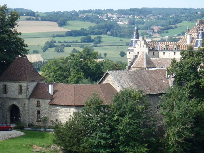
A hike in the forest very appreciated and rich in history passing in front of the Pupetières castle, where the poet Lamartine stayed, and the valley which inspired his famous poem.
The characteristics of the route.

Val-de-Virieu (38)
- Distance 8.17 km
- Elevation gain 290 m
- Elevation lost 290 m
- Min. elevation 456 m
- Max. elevation. 724 m
- Duration (depending on pace) 2h15
- Marking Yes
From the hunters' parking, follow the yellow signs and the following directional posts:
> Croix de l’Homnezy > Chemin de Ripaillon > Les Frênes (possibility to make a detour via "Les carrières d'argile" then "Sylve bénite" to reach the tithe barn of the former Carthusian monastery (detour of about 2,5km)) > Croix du Moine Mort > Vallon de Lamartine > Mallein > Combe Mounard > Les Platières > Return to the hunters' parking lotMarking : ROUTE From the hunters' car park, head towards the Croix de l'Homnézy. You will enjoy unobstructed views of the valleys and mountain ranges. The trail then gradually descends into the forest to the Croix du Moine Mort, named after the former Carthusian monastery located nearby. The forest trail then descends through the valley described by Lamartine in his poem. At the edge of the forest, the 17th-century Château de Pupetières stands below. Visits are possible (depending on opening times). You can also see the house of the Dutch painter Jongkind a few hundred metres further on. Finally, after a steep climb through the forest (+150m elevation gain), you return to Les Platières and then the car park. MARKINGS AND SIGNS From the hunters' parking, follow the yellow signs and the following directional posts: > Croix de l’Homnezy > Chemin de Ripaillon > Les Frênes (possibility to make a detour via "Les carrières d'argile" then "Sylve bénite" to reach the tithe barn of the former Carthusian monastery (detour of about 2,5km)) > Croix du Moine Mort > Vallon de Lamartine > Mallein > Combe Mounard > Les Platières > Return to the hunters' parking lotEquipments : Car park, Public WC, Admission fee : Free access.Opening : All year round daily.
> Croix de l’Homnezy > Chemin de Ripaillon > Les Frênes (possibility to make a detour via "Les carrières d'argile" then "Sylve bénite" to reach the tithe barn of the former Carthusian monastery (detour of about 2,5km)) > Croix du Moine Mort > Vallon de Lamartine > Mallein > Combe Mounard > Les Platières > Return to the hunters' parking lotMarking : ROUTE From the hunters' car park, head towards the Croix de l'Homnézy. You will enjoy unobstructed views of the valleys and mountain ranges. The trail then gradually descends into the forest to the Croix du Moine Mort, named after the former Carthusian monastery located nearby. The forest trail then descends through the valley described by Lamartine in his poem. At the edge of the forest, the 17th-century Château de Pupetières stands below. Visits are possible (depending on opening times). You can also see the house of the Dutch painter Jongkind a few hundred metres further on. Finally, after a steep climb through the forest (+150m elevation gain), you return to Les Platières and then the car park. MARKINGS AND SIGNS From the hunters' parking, follow the yellow signs and the following directional posts: > Croix de l’Homnezy > Chemin de Ripaillon > Les Frênes (possibility to make a detour via "Les carrières d'argile" then "Sylve bénite" to reach the tithe barn of the former Carthusian monastery (detour of about 2,5km)) > Croix du Moine Mort > Vallon de Lamartine > Mallein > Combe Mounard > Les Platières > Return to the hunters' parking lotEquipments : Car park, Public WC, Admission fee : Free access.Opening : All year round daily.
Area : Vals du Dauphiné
Report a problem
Website Features of the application :
- Location and orientation on detailed maps thanks to the GPS of your smartphone
- Description of routes and points of interest on the route
- Photo gallery by route
- Detailed elevation profile
- Route tracking alert to warn you if you stray from the route
- Send predefined messages by SMS to your contacts
- Emergency module: trigger a call or send an emergency SMS in case of problem
- Agenda: access to events organized in the department
- News: find in the application the latest news on the web portal
- Adding achievements
- Add reports in case of problems encountered on the routes
- Share on social networks
Add your time and share your feelings
Services nearby

Clog museum
Val-de-Virieu

Relais Cyné de Châbons
Châbons

Pays Voironnais Tourist Office, Lake Paladru information office
Charavines
Lake Paladru Archeological Museum
Villages du lac de Paladru

Espace Naturel Sensible des Marais de la Véronnière et du Courbon
Villages du lac de Paladru


Information updated on 2026-07-28 by Office de Tourisme des Vals du Dauphiné


Follow us on
the digital trails
the digital trails





The Isère Outdoor application was created
by the Département de l'Isère
Infos & contact
Conseil départemental de l'Isère
7 rue Fantin Latour
CS 41096
38 022 Grenoble cedex 1
Tel. 04 76 00 38 38
 Isère Outdoor - Parcours - Following Lamartine's footsteps
Hello, world! This is a toast message.
Isère Outdoor - Parcours - Following Lamartine's footsteps
Hello, world! This is a toast message.
Isère Outdoor - Parcours - Following Lamartine's footsteps
Hello, world! This is a toast message.


OK
Annuler