VTTAE - Etrip under the Dent de l'Ours
Add to my favorites

Caution! Zone of vigilance near the route
Aigle royal - du 01/01/2026 au 31/08/2026 In progress
An introductory loop for electrically-assisted mountain biking, recommended
for those who have already experienced mountain biking. This itinerary guides you through the Entremonts and opens onto breathtaking panoramas.
The characteristics of the route.

Saint-Pierre-d'Entremont (38)
- Distance 10.78 km
- Elevation gain 420 m
- Elevation lost 420 m
- Min. elevation 644 m
- Max. elevation. 952 m
- Duration (depending on pace) 3h
- Marking Yes
You'll find all the services you need (bike hire, restaurants) in the village of Saint-Pierre-d'Entremont.
(1) From the tourist office, head towards Saint-Pierre-de-Chartreuse. On leaving the village, take the D102b, which climbs to the right.
(2) At the first bend in the road, turn left onto the Chemin du Nan, signposted Le Villard. At the crow's feet, take the right-hand lane, which leads to the hamlet of Préversin. Turn left (south). 300 m further on, after the last house in the hamlet, take the path that rises up on the right towards the hamlet of Le Villard. Go up this path for about 1 km, then keep left at the crow's feet.
(3) The path comes out in the hamlet of Le Villard, just above the Entremonts goat farm, where you can buy goat's cheese direct! Continue straight ahead along the path towards Les Reys.
(4) At the yellow sign for ‘Les Reys - 940 m’, turn right onto the track leading to the RD102B. There is a fountain where you can quench your thirst.
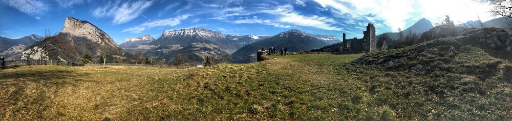
(6) Go through the hamlet of Les Reys. From this road on the mountainside, the view of the Granier, the Lances de Malissard and the Hauts de Chartreuse nature reserve is sumptuous! Stay on the D102b as far as Le Villard. Pass the holiday centre and a few bends, then take the Chemin des Fontanettes, a tarmac lane rising steeply on the left.
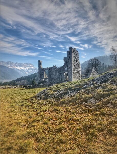
(7) At the top of the climb, turn left again. After a right-hand bend and a climb of around 50 m, turn right onto the small track just beside the private road. This path (Chemin des Champas) joins the Route de la Touvière after a kilometre of rolling road. Follow this road to the hamlet of Le Château.
(8) To reach the ruins of Château de Montbel, turn right down the small sloping track past the oven and wash-house. The peaks, gorges and valleys that make up the superb 360° panorama are detailed on a beautiful orientation table. Return to the road, leaving the one you came on on the right. Once you have passed a place called Paquet, turn left onto the ‘Randocroquis’ castle trail, which descends steeply and at length, before coming out onto the D102b. Turn left and follow the road back to Le Bourg.Marking : Approved by the Fédération Française de Cyclisme (French Cycling Federation), this brown signposting includes a blue "lightning bolt" for electrically-assisted bicycles.Equipments : Free car park, Car park, Public WC, Admission fee : Free access.Opening : From 01/05 to 31/10 daily. Subject to favorable weather.Services for cyclists : Entre Monts vélos: rental, sale of equipment, coffee breaks Contact: Tel: 04 79 36 01 76 / 06 19 94 98 05 / entre.monts.velos@gmail.com MCF mountain bike school: discovery, coaching contact: Cartusiana 04 38 86 91 31 / 06 16 95 78 48 / contact@cartusiana.comStep by step description : (1) From the tourist office, head for Saint-Pierre-de-Chartreuse. On leaving the village, take the D102b, which climbs to the right. (2) At the first bend, turn left on the Chemin du Nan, towards Le Villard. At the crow's-foot, take the right-hand lane to the hamlet of Préversin. Here, turn left (south). 300 m further on, after the last house in the hamlet, don't miss the path which rises to the right towards the hamlet of Le Villard. Climb this path for about 1 km, then keep left at the crow's-foot. (3) The path leads to the hamlet of Le Villard, just above the Labérou goat dairy, whose delicious goat cheeses are sold directly! Continue straight on, taking the path to Les Reys. (4) At the yellow sign "Les Reys - 940 m", turn left down a valley, then cross a meadow. The path leads into the village of Saint-Philibert, with its bread oven and ox-shoeing post (on the left at the crossroads), as well as the recently renovated church, and a fountain for drinking. church and fountain. Continue straight ahead, taking the path that begins at the 1st bend. (5) About 1 km further on, turn 180° right towards Les Reys and Saint-Pierre-d'Entremont. Follow the track, which leads to Les Arragons, on the D102b. (6) Pass through the hamlet of Les Arragons, then Les Reys. From this mountainside road, the view of the Granier, the Lances de Malissard and the Hauts de Chartreuse Nature Reserve is sumptuous! Stay on the D102b to Le Villard. Pass the vacation center and a few bends, then take the Chemin des Fontanettes, a tarmac road rising steeply on the left. (7) At the top of the climb, turn left again. After a right-hand bend and a climb of around 50 m, turn right onto the small track just beside the private road. This path (Chemin des Champas) joins the Route de la Touvière after a rolling kilometer. Follow this road to the hamlet of Château. (8) To reach the Château de Montbel ruins, turn right down the small sloping path past the oven and wash-house. The peaks, gorges and valleys that make up the superb 360° panorama are detailed on a beautiful orientation table. Return to the road, leaving to the right the one used on arrival. After Paquet, turn left onto the "Randocroquis" castle trail, which descends steeply and at length, before coming out onto the D102b. Turn left and follow the road to Le Bourg.
(1) From the tourist office, head towards Saint-Pierre-de-Chartreuse. On leaving the village, take the D102b, which climbs to the right.
(2) At the first bend in the road, turn left onto the Chemin du Nan, signposted Le Villard. At the crow's feet, take the right-hand lane, which leads to the hamlet of Préversin. Turn left (south). 300 m further on, after the last house in the hamlet, take the path that rises up on the right towards the hamlet of Le Villard. Go up this path for about 1 km, then keep left at the crow's feet.
(3) The path comes out in the hamlet of Le Villard, just above the Entremonts goat farm, where you can buy goat's cheese direct! Continue straight ahead along the path towards Les Reys.
(4) At the yellow sign for ‘Les Reys - 940 m’, turn right onto the track leading to the RD102B. There is a fountain where you can quench your thirst.
(6) Go through the hamlet of Les Reys. From this road on the mountainside, the view of the Granier, the Lances de Malissard and the Hauts de Chartreuse nature reserve is sumptuous! Stay on the D102b as far as Le Villard. Pass the holiday centre and a few bends, then take the Chemin des Fontanettes, a tarmac lane rising steeply on the left.
(7) At the top of the climb, turn left again. After a right-hand bend and a climb of around 50 m, turn right onto the small track just beside the private road. This path (Chemin des Champas) joins the Route de la Touvière after a kilometre of rolling road. Follow this road to the hamlet of Le Château.
(8) To reach the ruins of Château de Montbel, turn right down the small sloping track past the oven and wash-house. The peaks, gorges and valleys that make up the superb 360° panorama are detailed on a beautiful orientation table. Return to the road, leaving the one you came on on the right. Once you have passed a place called Paquet, turn left onto the ‘Randocroquis’ castle trail, which descends steeply and at length, before coming out onto the D102b. Turn left and follow the road back to Le Bourg.Marking : Approved by the Fédération Française de Cyclisme (French Cycling Federation), this brown signposting includes a blue "lightning bolt" for electrically-assisted bicycles.Equipments : Free car park, Car park, Public WC, Admission fee : Free access.Opening : From 01/05 to 31/10 daily. Subject to favorable weather.Services for cyclists : Entre Monts vélos: rental, sale of equipment, coffee breaks Contact: Tel: 04 79 36 01 76 / 06 19 94 98 05 / entre.monts.velos@gmail.com MCF mountain bike school: discovery, coaching contact: Cartusiana 04 38 86 91 31 / 06 16 95 78 48 / contact@cartusiana.comStep by step description : (1) From the tourist office, head for Saint-Pierre-de-Chartreuse. On leaving the village, take the D102b, which climbs to the right. (2) At the first bend, turn left on the Chemin du Nan, towards Le Villard. At the crow's-foot, take the right-hand lane to the hamlet of Préversin. Here, turn left (south). 300 m further on, after the last house in the hamlet, don't miss the path which rises to the right towards the hamlet of Le Villard. Climb this path for about 1 km, then keep left at the crow's-foot. (3) The path leads to the hamlet of Le Villard, just above the Labérou goat dairy, whose delicious goat cheeses are sold directly! Continue straight on, taking the path to Les Reys. (4) At the yellow sign "Les Reys - 940 m", turn left down a valley, then cross a meadow. The path leads into the village of Saint-Philibert, with its bread oven and ox-shoeing post (on the left at the crossroads), as well as the recently renovated church, and a fountain for drinking. church and fountain. Continue straight ahead, taking the path that begins at the 1st bend. (5) About 1 km further on, turn 180° right towards Les Reys and Saint-Pierre-d'Entremont. Follow the track, which leads to Les Arragons, on the D102b. (6) Pass through the hamlet of Les Arragons, then Les Reys. From this mountainside road, the view of the Granier, the Lances de Malissard and the Hauts de Chartreuse Nature Reserve is sumptuous! Stay on the D102b to Le Villard. Pass the vacation center and a few bends, then take the Chemin des Fontanettes, a tarmac road rising steeply on the left. (7) At the top of the climb, turn left again. After a right-hand bend and a climb of around 50 m, turn right onto the small track just beside the private road. This path (Chemin des Champas) joins the Route de la Touvière after a rolling kilometer. Follow this road to the hamlet of Château. (8) To reach the Château de Montbel ruins, turn right down the small sloping path past the oven and wash-house. The peaks, gorges and valleys that make up the superb 360° panorama are detailed on a beautiful orientation table. Return to the road, leaving to the right the one used on arrival. After Paquet, turn left onto the "Randocroquis" castle trail, which descends steeply and at length, before coming out onto the D102b. Turn left and follow the road to Le Bourg.
Report a problem
Website Pdf file Features of the application :
- Location and orientation on detailed maps thanks to the GPS of your smartphone
- Description of routes and points of interest on the route
- Photo gallery by route
- Detailed elevation profile
- Route tracking alert to warn you if you stray from the route
- Send predefined messages by SMS to your contacts
- Emergency module: trigger a call or send an emergency SMS in case of problem
- Agenda: access to events organized in the department
- News: find in the application the latest news on the web portal
- Adding achievements
- Add reports in case of problems encountered on the routes
- Share on social networks
Add your time and share your feelings
Services nearby

Coeur de Chartreuse Tourist Information center at Saint Pierre d'Entremont
Saint-Pierre-d'Entremont
Coeur de Chartreuse Tourist Information center at Saint Pierre de Chartreuse
Saint-Pierre-de-Chartreuse

Museum of la Grande Chartreuse
Saint-Pierre-de-Chartreuse
Coeur de Chartreuse Tourist Information center at Saint Laurent du Pont
Saint-Laurent-du-Pont
Museum of Contemporary Sacred Art
Saint-Pierre-de-Chartreuse


Information updated on 2026-05-13 by Isère Attractivité


Follow us on
the digital trails
the digital trails


![]()
The Isère Outdoor application was created
by the Département de l'Isère
Infos & contact
Conseil départemental de l'Isère
7 rue Fantin Latour
CS 41096
38 022 Grenoble cedex 1
Tel. 04 76 00 38 38
 Isère Outdoor - Parcours - VTTAE - Etrip under the Dent de l'Ours
Hello, world! This is a toast message.
Isère Outdoor - Parcours - VTTAE - Etrip under the Dent de l'Ours
Hello, world! This is a toast message.
Isère Outdoor - Parcours - VTTAE - Etrip under the Dent de l'Ours
Hello, world! This is a toast message.


OK
Annuler