Around the Castle of Virieu
Add to my favorites

A sportive ascent to reach the medieval castle of Virieu and discover panoramas on the valley of the Haute Bourbre and the summits of the Bugey, the Chartreuse and the Avant-Pays Savoyard.
The characteristics of the route.

Val-de-Virieu (38)
- Distance 8.13 km
- Elevation gain 270 m
- Elevation lost 270 m
- Min. elevation 411 m
- Max. elevation. 668 m
- Duration (depending on pace) 2h30
- Marking Yes
ROUTE
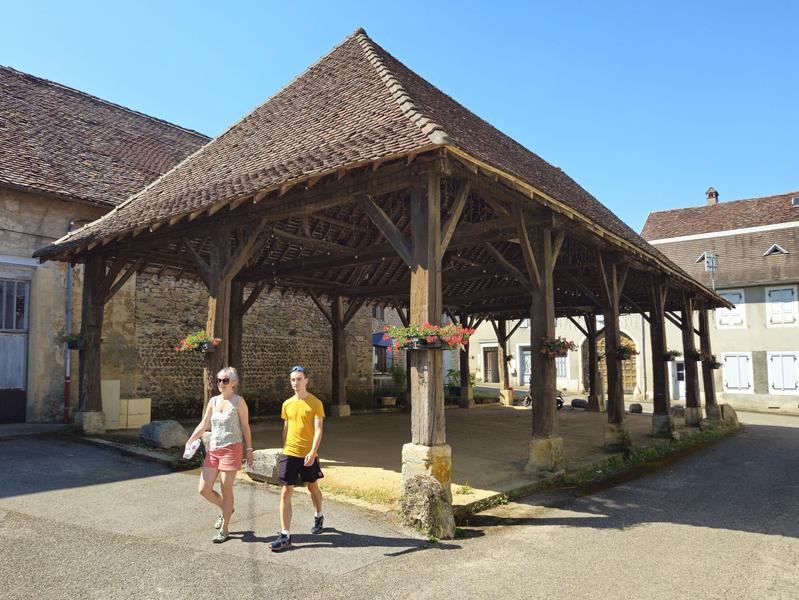
From the church, you pace up and down through the streets of Virieu, a medieval village built at the foot of its castle. The picturesque charm of the village centre can be seen in the typical Dauphiné houses, the murals frescos recounting the history of the village, the Place du Trêve painted by the impressionist Jongkind and the wooden covered market hall with its gable roof made of tortoiseshell tiles. A map of the village is available from the town hall.
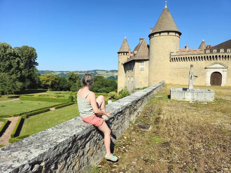
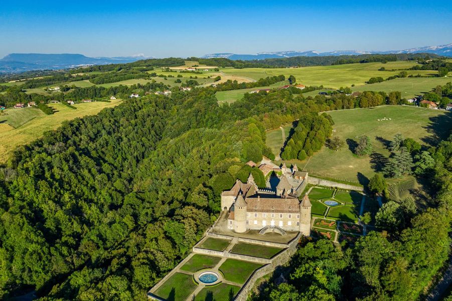
Once you reach Le Trêve, head up towards the Château de Virieu either by the road or along a shady path (not recommended for mountain bikes or horses). You can visit the castle and the Galoche museum, which traces the history of this shoe, a cousin of the clog (depending on opening hours).
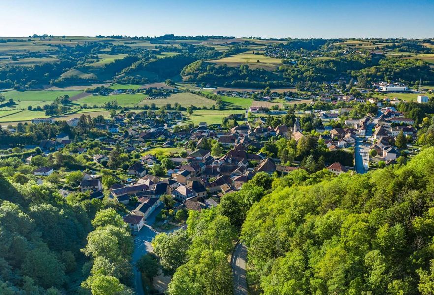
Then, as far as the Croix de l'Homnézy, there are unobstructed views over the valleys and mountain ranges.
Continue upwards pass the hunters' hut to reach Les Platières. Finally, you return to Virieu, overlooking the Bourbre valley.
WAYMARKING AND SIGNPOSTING
From the Virieu-sur-Bourbre SNCF station, follow the yellow signs to the village of Virieu (alternative starting point - car park in front of the church).
From the church in Virieu, follow the yellow markings and the following signposts:
> Le Trêve (2 options to go up to the castle : by the path (pass in front of the paddle wheel) or by the road (which goes up on your right at the Trêve crossroads)) > Château de Virieu > Les Cardelles > Croix de l'Homnezy > Les Platières > Les Tournelles > Le Trêve > Return to the village center parking lot or to the train station.
Please note: add 2.2km (1.1km one way) if starting from the SNCF station.Marking : From the Virieu-sur-Bourbre SNCF station, follow the yellow signs to the village of Virieu (alternative starting point - car park in front of the church). From the church in Virieu, follow the yellow markings and the following signposts: > Le Trêve (2 options to go up to the castle : by the path (pass in front of the paddle wheel) or by the road (which goes up on your right at the Trêve crossroads)) > Château de Virieu > Les Cardelles > Croix de l'Homnezy > Les Platières > Les Tournelles > Le Trêve > Return to the village center parking lot or to the train station.Equipments : Public WC, Car park, Admission fee : Free access.Opening : All year round daily.
From the church, you pace up and down through the streets of Virieu, a medieval village built at the foot of its castle. The picturesque charm of the village centre can be seen in the typical Dauphiné houses, the murals frescos recounting the history of the village, the Place du Trêve painted by the impressionist Jongkind and the wooden covered market hall with its gable roof made of tortoiseshell tiles. A map of the village is available from the town hall.
Once you reach Le Trêve, head up towards the Château de Virieu either by the road or along a shady path (not recommended for mountain bikes or horses). You can visit the castle and the Galoche museum, which traces the history of this shoe, a cousin of the clog (depending on opening hours).
Then, as far as the Croix de l'Homnézy, there are unobstructed views over the valleys and mountain ranges.
Continue upwards pass the hunters' hut to reach Les Platières. Finally, you return to Virieu, overlooking the Bourbre valley.
WAYMARKING AND SIGNPOSTING
From the Virieu-sur-Bourbre SNCF station, follow the yellow signs to the village of Virieu (alternative starting point - car park in front of the church).
From the church in Virieu, follow the yellow markings and the following signposts:
> Le Trêve (2 options to go up to the castle : by the path (pass in front of the paddle wheel) or by the road (which goes up on your right at the Trêve crossroads)) > Château de Virieu > Les Cardelles > Croix de l'Homnezy > Les Platières > Les Tournelles > Le Trêve > Return to the village center parking lot or to the train station.
Please note: add 2.2km (1.1km one way) if starting from the SNCF station.Marking : From the Virieu-sur-Bourbre SNCF station, follow the yellow signs to the village of Virieu (alternative starting point - car park in front of the church). From the church in Virieu, follow the yellow markings and the following signposts: > Le Trêve (2 options to go up to the castle : by the path (pass in front of the paddle wheel) or by the road (which goes up on your right at the Trêve crossroads)) > Château de Virieu > Les Cardelles > Croix de l'Homnezy > Les Platières > Les Tournelles > Le Trêve > Return to the village center parking lot or to the train station.Equipments : Public WC, Car park, Admission fee : Free access.Opening : All year round daily.
Area : Vals du Dauphiné
Report a problem
Website Autour du Château de Virieu Features of the application :
- Location and orientation on detailed maps thanks to the GPS of your smartphone
- Description of routes and points of interest on the route
- Photo gallery by route
- Detailed elevation profile
- Route tracking alert to warn you if you stray from the route
- Send predefined messages by SMS to your contacts
- Emergency module: trigger a call or send an emergency SMS in case of problem
- Agenda: access to events organized in the department
- News: find in the application the latest news on the web portal
- Adding achievements
- Add reports in case of problems encountered on the routes
- Share on social networks
Add your time and share your feelings
Services nearby

Clog museum
Val-de-Virieu

Relais Cyné de Châbons
Châbons
Lake Paladru Archeological Museum
Villages du lac de Paladru

Espace Naturel Sensible des Marais de la Véronnière et du Courbon
Villages du lac de Paladru

Pays Voironnais Tourist Office, Lake Paladru information office
Charavines


Information updated on 2025-12-01 by Office de Tourisme des Vals du Dauphiné


Follow us on
the digital trails
the digital trails


![]()
The Isère Outdoor application was created
by the Département de l'Isère
Infos & contact
Conseil départemental de l'Isère
7 rue Fantin Latour
CS 41096
38 022 Grenoble cedex 1
Tel. 04 76 00 38 38
 Isère Outdoor - Parcours - Around the Castle of Virieu
Hello, world! This is a toast message.
Isère Outdoor - Parcours - Around the Castle of Virieu
Hello, world! This is a toast message.
Isère Outdoor - Parcours - Around the Castle of Virieu
Hello, world! This is a toast message.


OK
Annuler