Les 7 Laux - hike from Rivier d'Allemond
Add to my favorites

Caution! Zone of vigilance near the route
Les 7 Laux - du 20/06/2026 au 20/09/2026 In progress
Aigle royal - du 01/01/2026 au 31/08/2026 In progress
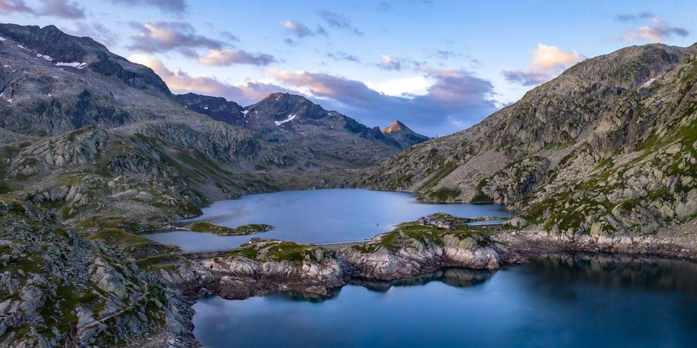
This itinerary takes you through a succession of Isère's most famous lakes (Laux). At times, the slope is quite steep, but you'll be amply rewarded by the discovery of these beautiful mountain lakes and the various surrounding massifs.
The characteristics of the route.

Allemond (38)
- Distance 11.75 km
- Elevation gain 950 m
- Elevation lost 950 m
- Min. elevation 1249 m
- Max. elevation. 2189 m
- Duration (depending on pace) 6h
- Marking Yes
A great spot for ibex! This area is home to many chamois and ibex, a species reintroduced in 1983 by hunters and EDF during the construction of the Grand' Maison Dam. The 7 Laux, despite what their name suggests, are actually 10: Lake Sagne, Lake Corne, Lake Jeplan, Lake Agnelin, Lake Cos, Lake Blanc, Lake Cottepens, Lake Carré, Lake Motte, and Lake Noir.
As you follow the lakes, you’ll cross the Belledonne Massif.Marking : The trail is part of the Tour des Sept Laux, a yellow/red GRP®.Good plans : For the return trip, you can take an alternate route via the Col de la Vache; this involves a descent of 1,200 meters.Delicate passages : The route is equipped in places with concrete steps and cables, which can be useful on the descent. To be avoided on rainy days, as some sections are slippery.Admission fee : Free access.Opening : From 01/05 to 31/10 daily. Subject to snow conditions.Step by step description : Shortly after Rivier d'Allemond, park on the old Croix de Fer Pass road, which branches off to the left and ends in a dead end, in front of the massive rockslide that forced its reconstruction on the opposite slope. After Rivier, continue along the road for about 2 km until you reach the intersection of the old road (closed) and the new one, which winds down to the valley floor. The trailhead is at this intersection. The trail follows the mountainside for about 1 km, then climbs in tight switchbacks up the Combe des 7 Laux. At the top of the plateau, you’ll first come to Lac de la Sagne. The series of lakes takes you from the Oisans region to the Grésivaudan region.Warning : As this route is potentially subject to severe damage due to major weather events and its viability may be uncertain, please enquire before embarking on it.
As you follow the lakes, you’ll cross the Belledonne Massif.Marking : The trail is part of the Tour des Sept Laux, a yellow/red GRP®.Good plans : For the return trip, you can take an alternate route via the Col de la Vache; this involves a descent of 1,200 meters.Delicate passages : The route is equipped in places with concrete steps and cables, which can be useful on the descent. To be avoided on rainy days, as some sections are slippery.Admission fee : Free access.Opening : From 01/05 to 31/10 daily. Subject to snow conditions.Step by step description : Shortly after Rivier d'Allemond, park on the old Croix de Fer Pass road, which branches off to the left and ends in a dead end, in front of the massive rockslide that forced its reconstruction on the opposite slope. After Rivier, continue along the road for about 2 km until you reach the intersection of the old road (closed) and the new one, which winds down to the valley floor. The trailhead is at this intersection. The trail follows the mountainside for about 1 km, then climbs in tight switchbacks up the Combe des 7 Laux. At the top of the plateau, you’ll first come to Lac de la Sagne. The series of lakes takes you from the Oisans region to the Grésivaudan region.Warning : As this route is potentially subject to severe damage due to major weather events and its viability may be uncertain, please enquire before embarking on it.
Area : Oisans
Report a problem
Website Features of the application :
- Location and orientation on detailed maps thanks to the GPS of your smartphone
- Description of routes and points of interest on the route
- Photo gallery by route
- Detailed elevation profile
- Route tracking alert to warn you if you stray from the route
- Send predefined messages by SMS to your contacts
- Emergency module: trigger a call or send an emergency SMS in case of problem
- Agenda: access to events organized in the department
- News: find in the application the latest news on the web portal
- Adding achievements
- Add reports in case of problems encountered on the routes
- Share on social networks
Add your time and share your feelings
Services nearby

Ibex museum - Space York Mallory
Allemond

Refuge le Habert d'Aiguebelle
Laval
Refuge des 7 Laux
Le Haut-Bréda
Vaujany museum
Vaujany

Office de Tourisme de Vaujany
Vaujany




Follow us on
the digital trails
the digital trails





The Isère Outdoor application was created
by the Département de l'Isère
Infos & contact
Conseil départemental de l'Isère
7 rue Fantin Latour
CS 41096
38 022 Grenoble cedex 1
Tel. 04 76 00 38 38
 Isère Outdoor - Parcours - Les 7 Laux - hike from Rivier d'Allemond
Hello, world! This is a toast message.
Isère Outdoor - Parcours - Les 7 Laux - hike from Rivier d'Allemond
Hello, world! This is a toast message.
Isère Outdoor - Parcours - Les 7 Laux - hike from Rivier d'Allemond
Hello, world! This is a toast message.


OK
Annuler