Hiking - Col du Vallon du lac de la Muzelle to lac Lauvitel
Add to my favorites

Caution! Zone of vigilance near the route
La Muzelle - du 20/06/2026 au 05/10/2026 In progress
Route closed
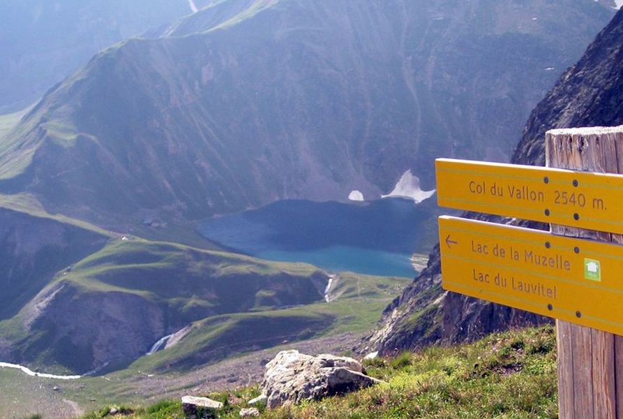
A pass between the 2 best hikes in the Vénéon Valley overlooking an unavoidable view over the valley! Hiking with some delicate and technical passages.
The characteristics of the route.

Venosc (38)
- Distance 13.63 km
- Elevation gain 1480 m
- Elevation lost 1480 m
- Min. elevation 1512 m
- Max. elevation. 2526 m
- Duration (depending on pace) 3h30
- Marking Yes
This site is located in the heart of the Écrins National Park and is subject to specific regulations. We invite you to adopt the right practices during your visit to help protect this natural heritage.
TECHNICAL INFORMATION :
Start: Lake Muzelle
Difference in altitude: 500m
Duration: 3h30
Distance: 8 km
Level : Difficult
TOPO AND MAP :
OBP map n°5 (Oisans au Bout des Pieds)
IGN TOP 25 map n°3336 ET
ROUTE :
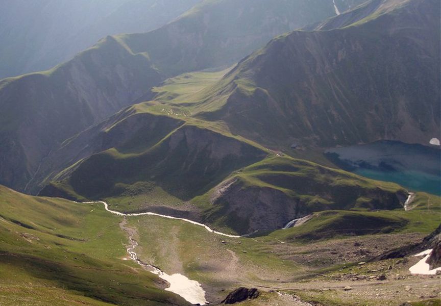
From "Lac de la Muzelle". To reach the fork leading to the pass, go around the lake to the right, cross the lawn and reach the start of the path in the scree (signposted Col du Vallon). The ascent path is nearby. [Allow 1h30 from the refuge de la Muzelle]. From the col, you'll have a magnificent view of the surrounding area. Start the descent towards Lac du Lauvitel, keeping to the left. After a long series of switchbacks, you'll reach a characteristic rocky crest, with a fine view over the lake. From here, you have to cross a large ravine on the right (in wet weather, crossing a slab can be dangerous, and crossing the béquet can be impressive). The path climbs up a little (10 mins) before leading to the mountain pastures above the lake (not recommended in wet weather) [allow around 2 hrs for the descent to the lake].
Please note: this description only covers the passage from one lake to the other! For a description of the complete loop, see the “Grand Tour des Lacs Muzelle et Lauvitel” page.Admission fee : Free access.Opening : From 13/06 to 31/10/2026 daily. Depending on weather conditions. Subject to favorable snow and weather conditions.
TECHNICAL INFORMATION :
Start: Lake Muzelle
Difference in altitude: 500m
Duration: 3h30
Distance: 8 km
Level : Difficult
TOPO AND MAP :
OBP map n°5 (Oisans au Bout des Pieds)
IGN TOP 25 map n°3336 ET
ROUTE :
From "Lac de la Muzelle". To reach the fork leading to the pass, go around the lake to the right, cross the lawn and reach the start of the path in the scree (signposted Col du Vallon). The ascent path is nearby. [Allow 1h30 from the refuge de la Muzelle]. From the col, you'll have a magnificent view of the surrounding area. Start the descent towards Lac du Lauvitel, keeping to the left. After a long series of switchbacks, you'll reach a characteristic rocky crest, with a fine view over the lake. From here, you have to cross a large ravine on the right (in wet weather, crossing a slab can be dangerous, and crossing the béquet can be impressive). The path climbs up a little (10 mins) before leading to the mountain pastures above the lake (not recommended in wet weather) [allow around 2 hrs for the descent to the lake].
Please note: this description only covers the passage from one lake to the other! For a description of the complete loop, see the “Grand Tour des Lacs Muzelle et Lauvitel” page.Admission fee : Free access.Opening : From 13/06 to 31/10/2026 daily. Depending on weather conditions. Subject to favorable snow and weather conditions.
Area : Oisans
Report a problem
Website Pdf file Features of the application :
- Location and orientation on detailed maps thanks to the GPS of your smartphone
- Description of routes and points of interest on the route
- Photo gallery by route
- Detailed elevation profile
- Route tracking alert to warn you if you stray from the route
- Send predefined messages by SMS to your contacts
- Emergency module: trigger a call or send an emergency SMS in case of problem
- Agenda: access to events organized in the department
- News: find in the application the latest news on the web portal
- Adding achievements
- Add reports in case of problems encountered on the routes
- Share on social networks
Add your time and share your feelings
Services nearby

La Muzelle Hut
Venosc

Venosc Tourist Office - Les 2 Alpes
Venosc
Mountain hut l'Alpe du Pin
Saint-Christophe-en-Oisans - La Bérarde

Museum " mountaineering Memory"
Saint-Christophe-en-Oisans - La Bérarde
Tourist office of St-Christophe-en-Oisans - La Bérarde
Saint-Christophe-en-Oisans - La Bérarde


Information updated on 2026-05-24 by Office de Tourisme des 2 Alpes


Follow us on
the digital trails
the digital trails


![]()
The Isère Outdoor application was created
by the Département de l'Isère
Infos & contact
Conseil départemental de l'Isère
7 rue Fantin Latour
CS 41096
38 022 Grenoble cedex 1
Tel. 04 76 00 38 38
 Isère Outdoor - Parcours - Hiking - Col du Vallon du lac de la Muzelle to lac Lauvitel
Hello, world! This is a toast message.
Isère Outdoor - Parcours - Hiking - Col du Vallon du lac de la Muzelle to lac Lauvitel
Hello, world! This is a toast message.
Isère Outdoor - Parcours - Hiking - Col du Vallon du lac de la Muzelle to lac Lauvitel
Hello, world! This is a toast message.


OK
Annuler