Villard Reculas - Hiking from Le Raffour (Bourg-d'Oisans)
Add to my favorites

Caution! Zone of vigilance near the route
Alpage de Villard Reculas - du 15/06/2026 au 15/10/2026 Upcoming
Circaète Jean-le-Blanc - du 01/03/2026 au 30/09/2026 In progress
The path goes through a forest of beech trees, oaks and spruce, home to a wide range of animals. In Villard Reculas, you will be walking among pastureland and meadows.
The characteristics of the route.

Le Bourg-d'Oisans (38)
- Distance 11.5 km
- Elevation gain 870 m
- Elevation lost 870 m
- Min. elevation 712 m
- Max. elevation. 1493 m
- Duration (depending on pace) 5h
- Marking Yes
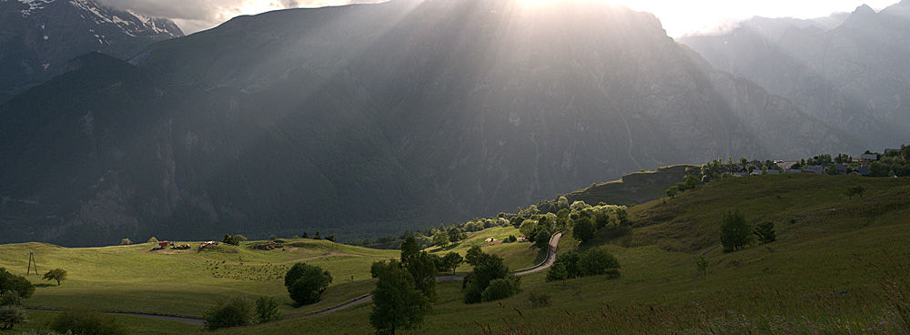
The village houses are enhanced by a harmonious style of architecture, featuring stonework and timber. There is a lovely view over the Bourg d'Oisans plain and the Taillefer massif.
TECHNICAL INFORMATION
Starting point: Bourg d'Oisans
Height gain: 720 m
Total duration: 3 hours
Distance: 5 km
Level: moderate
MAP
Map IGN Top 25 no.3335 E
Departure from Le Rafour (719m). Take the road that crosses the small hamlet of Le Rafour, signposted 'Pied de Combe creuse'.
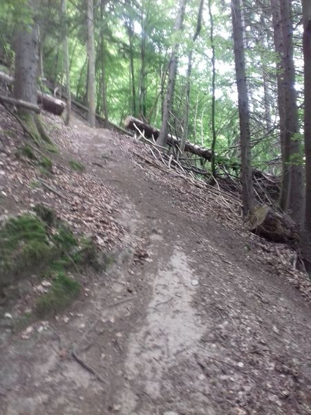
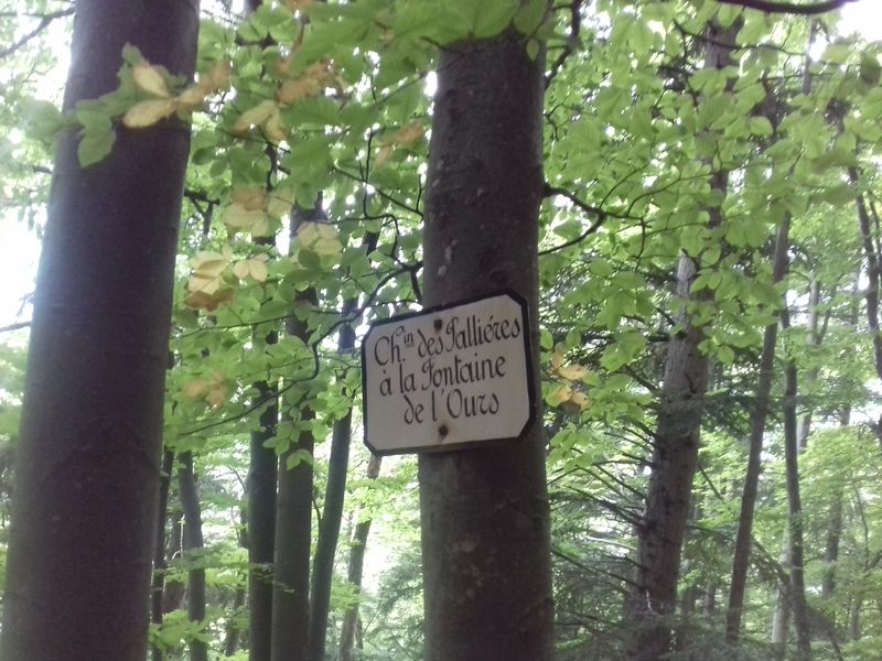
The climb begins at the foot of Combe Creuse! A very steep climb in the forest of about 1h45 to 'La Fontaine de l'Ours' (1274m).
From there you continue the climb, which becomes slightly less steep. You will arrive on the road that leads to Villard Reculas. At 100m on the right, on the other side of the road, you see a path that goes up. There are no signs or markings. You go up this path and after 100m you see the pole that indicates 'Les Essarts' (1435m). You turn right, in the direction of Villard Reculas, it is still an hour's walk in the forest to get to the center.
From Villard Reculas you have a breathtaking view over the plain of Bourg d'Oisans, the Taillefer, Belledonne and the Ecrins.
The return can be done via the same path. You can also choose to go down via Sardonne, the road then becomes a bit longer but also much less steep on the descent. In Les Essarts direction Sardonne, Combe de la Voute and then direction Le Rafour. Total ascent time: 3h00, descent: about 2h30.Opening : From 01/05 to 31/10 daily.
TECHNICAL INFORMATION
Starting point: Bourg d'Oisans
Height gain: 720 m
Total duration: 3 hours
Distance: 5 km
Level: moderate
MAP
Map IGN Top 25 no.3335 E
Departure from Le Rafour (719m). Take the road that crosses the small hamlet of Le Rafour, signposted 'Pied de Combe creuse'.
The climb begins at the foot of Combe Creuse! A very steep climb in the forest of about 1h45 to 'La Fontaine de l'Ours' (1274m).
From there you continue the climb, which becomes slightly less steep. You will arrive on the road that leads to Villard Reculas. At 100m on the right, on the other side of the road, you see a path that goes up. There are no signs or markings. You go up this path and after 100m you see the pole that indicates 'Les Essarts' (1435m). You turn right, in the direction of Villard Reculas, it is still an hour's walk in the forest to get to the center.
From Villard Reculas you have a breathtaking view over the plain of Bourg d'Oisans, the Taillefer, Belledonne and the Ecrins.
The return can be done via the same path. You can also choose to go down via Sardonne, the road then becomes a bit longer but also much less steep on the descent. In Les Essarts direction Sardonne, Combe de la Voute and then direction Le Rafour. Total ascent time: 3h00, descent: about 2h30.Opening : From 01/05 to 31/10 daily.
Area : Oisans
Report a problem
Website TOPO_Le Rafour - Villard Reculas Features of the application :
- Location and orientation on detailed maps thanks to the GPS of your smartphone
- Description of routes and points of interest on the route
- Photo gallery by route
- Detailed elevation profile
- Route tracking alert to warn you if you stray from the route
- Send predefined messages by SMS to your contacts
- Emergency module: trigger a call or send an emergency SMS in case of problem
- Agenda: access to events organized in the department
- News: find in the application the latest news on the web portal
- Adding achievements
- Add reports in case of problems encountered on the routes
- Share on social networks
Add your time and share your feelings
Services nearby

Cross-country skiing centre
Allemond

Tourist office of Allemond
Allemond
Tourist office of Villard-Reculas
Villard-Reculas
Oz en Oisans Tourist Office
Oz-en-Oisans

EDF Hydrélec museum
Vaujany


Information updated on 2026-03-11 by Oisans Tourisme


Follow us on
the digital trails
the digital trails


![]()
The Isère Outdoor application was created
by the Département de l'Isère
Infos & contact
Conseil départemental de l'Isère
7 rue Fantin Latour
CS 41096
38 022 Grenoble cedex 1
Tel. 04 76 00 38 38
 Isère Outdoor - Parcours - Villard Reculas - Hiking from Le Raffour (Bourg-d'Oisans)
Hello, world! This is a toast message.
Isère Outdoor - Parcours - Villard Reculas - Hiking from Le Raffour (Bourg-d'Oisans)
Hello, world! This is a toast message.
Isère Outdoor - Parcours - Villard Reculas - Hiking from Le Raffour (Bourg-d'Oisans)
Hello, world! This is a toast message.


OK
Annuler