Boucle du Perron
Add to my favorites

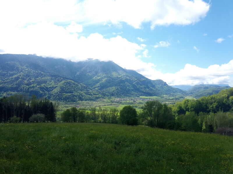
Superb panoramas over the plain of Saint-Laurent-du-Pont and the Chartreuse massif. On the road between the Bâches and the Côtes, a page of geology opens in front of you: you will easily imagine the large lake resulting from the glacial excavations of the Quaternary, which still existed two centuries ago!
The characteristics of the route.

Saint-Laurent-du-Pont (38)
- Distance 6.2 km
- Elevation gain 210 m
- Elevation lost 200 m
- Min. elevation 415 m
- Max. elevation. 600 m
- Duration (depending on pace) 2h30
- Marking Yes
In the center of the hamlet Les Terpends (1), find the path towards Néplier (yellow signs). It goes up between the houses. Meet a B-road in the hamlet of Mainlières (or Millières) and keep going north (yellow signs on the telephone poles) to Néplier. After the yellow signs of Néplier, take the track that goes up on the left along the canal (2). A short moment after, turn left. At the next junction, keep walking on the right. Cross the hamlet of Les Bâches and turn left towards La Côte (3). Cross the hamlet of La Côte and follow the road on the left to Barnériat (4).
At the end of the hamlet, stay on the path that goes up. When you reach the road, go left towards Le Perron. Cross the hamlet until the croix du Perron (5). Turn left between the houses towards Terpends. At the fork, go down on your right. Meet the road and keep going down to your car.Admission fee : Free of charge.Opening : From 01/05 to 30/11. Subject to favorable weather.Step by step description : In the center of the hamlet of Les Terpends (1), find the path that ascends between the houses towards Néplier (yellow signs). At the top of the path, continue on the right along the communal road in the hamlet of Mainlières (or Millières), following the yellow markings on the telephone poles towards Néplier. After the yellow signs for Néplier, take the track that ascends to the left along a canal (2). Shortly after, turn left (yellow arrow on marker posts), then at the next fork, continue to the right (yellow arrow on marker posts). At the top of the path, take the small road to cross the hamlet of Les Bâches and turn left towards La Côte (3), following the road. Cross the hamlet of La Côte, where the view extends over the Herretang peat bogs, dominated by the Grande Sure. Take the road on the left towards Barnériat (4). At the end of the hamlet, continue on the path that ascends and passes in front of the houses. At the intersection with a road, continue left towards Le Perron. Cross the hamlet until you reach the Croix du Perron (5). Turn left between the houses towards Terpends. At the fork, descend to the right. Meet the road, turn left, and continue descending to the starting point.
At the end of the hamlet, stay on the path that goes up. When you reach the road, go left towards Le Perron. Cross the hamlet until the croix du Perron (5). Turn left between the houses towards Terpends. At the fork, go down on your right. Meet the road and keep going down to your car.Admission fee : Free of charge.Opening : From 01/05 to 30/11. Subject to favorable weather.Step by step description : In the center of the hamlet of Les Terpends (1), find the path that ascends between the houses towards Néplier (yellow signs). At the top of the path, continue on the right along the communal road in the hamlet of Mainlières (or Millières), following the yellow markings on the telephone poles towards Néplier. After the yellow signs for Néplier, take the track that ascends to the left along a canal (2). Shortly after, turn left (yellow arrow on marker posts), then at the next fork, continue to the right (yellow arrow on marker posts). At the top of the path, take the small road to cross the hamlet of Les Bâches and turn left towards La Côte (3), following the road. Cross the hamlet of La Côte, where the view extends over the Herretang peat bogs, dominated by the Grande Sure. Take the road on the left towards Barnériat (4). At the end of the hamlet, continue on the path that ascends and passes in front of the houses. At the intersection with a road, continue left towards Le Perron. Cross the hamlet until you reach the Croix du Perron (5). Turn left between the houses towards Terpends. At the fork, descend to the right. Meet the road, turn left, and continue descending to the starting point.
Area : Cœur de Chartreuse
Report a problem
Pdf file Features of the application :
- Location and orientation on detailed maps thanks to the GPS of your smartphone
- Description of routes and points of interest on the route
- Photo gallery by route
- Detailed elevation profile
- Route tracking alert to warn you if you stray from the route
- Send predefined messages by SMS to your contacts
- Emergency module: trigger a call or send an emergency SMS in case of problem
- Agenda: access to events organized in the department
- News: find in the application the latest news on the web portal
- Adding achievements
- Add reports in case of problems encountered on the routes
- Share on social networks
Add your time and share your feelings
Services nearby

Espace Naturel Sensible des Tourbières de l'Herretang
Saint-Laurent-du-Pont

Coeur de Chartreuse Tourist Information center at Saint Laurent du Pont
Saint-Laurent-du-Pont

Museum of la Grande Chartreuse
Saint-Pierre-de-Chartreuse
Mainssieux Museum
Voiron
Pays Voironnais Tourist Office, Voiron information office
Voiron


Information updated on 2024-09-12 by Chartreuse Tourisme


Follow us on
the digital trails
the digital trails


![]()
The Isère Outdoor application was created
by the Département de l'Isère
Infos & contact
Conseil départemental de l'Isère
7 rue Fantin Latour
CS 41096
38 022 Grenoble cedex 1
Tel. 04 76 00 38 38
 Isère Outdoor - Parcours - Boucle du Perron
Hello, world! This is a toast message.
Isère Outdoor - Parcours - Boucle du Perron
Hello, world! This is a toast message.
Isère Outdoor - Parcours - Boucle du Perron
Hello, world! This is a toast message.


OK
Annuler