Sommet du Grand Som par le Racapé
Add to my favorites

Caution! Zone of vigilance near the route
Mauverney - du 05/07/2026 au 07/09/2026 In progress
Grand Som - du 05/07/2026 au 07/09/2026 In progress
Bellefont - du 01/06/2026 au 31/10/2026 In progress
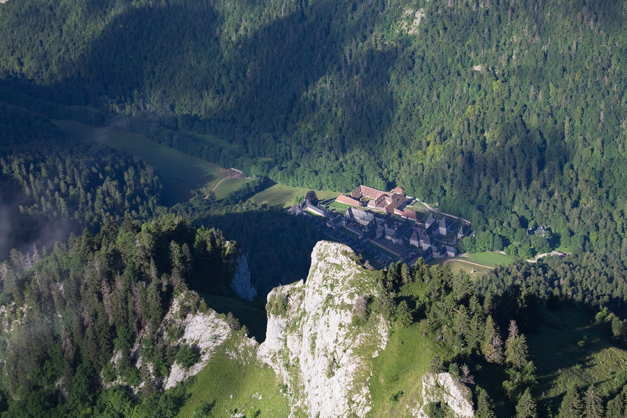
The Grand Som (2,026 m) overlooks the monastery of La Grande Chartreuse with its majestic cliffs and sharp crests. Beware: this hike could be very dangerous when the ground is wet and when the weather is bad (rain and/or storm). Don’t take young children with you.
The characteristics of the route.

Saint-Pierre-de-Chartreuse (38)
- Distance 8.1 km
- Elevation gain 900 m
- Elevation lost 900 m
- Min. elevation 1138 m
- Max. elevation. 2016 m
- Duration (depending on pace) 5h
- Marking Yes
The Sommet du Grand Som is an iconic hike in the Chartreuse massif, offering breathtaking panoramas of the Alps and the surrounding valleys.
Nearby Visit Ideas:
Musée de la Grande Chartreuse (7 km from the start): audio-guided tours.
Petits Jardiniers (9 km from the start): cultivation of medicinal plants.
Fleurs de Lyne (3 km from the start): soap-making.
Musée d'Art Sacré Contemporain (7 km from the start): St. Hugues Church.
For all information and more visit ideas, check chartreuse-tourisme.com/rsf.
Information / Safety:
It is important to adopt some rules and follow guidelines to fully enjoy your walks and hikes safely! Before you set out, follow our recommendations and advice at chartreuse-tourisme.com/conseils-rando-trail (or request them at tourist offices).
Please note: a mountain guide is a specialist in mountain wildlife and flora, off-trail hikes away from the crowds, local history, alpine and rural traditions, etc., ensuring safety! Make use of their services! A detailed list can be found at chartreuse-tourisme.com/accomp (or at tourist offices).
You hike at your own risk. Chartreuse Tourism and the tourist offices cannot be held responsible for the proposed routes.
Useful Numbers:
Weather (must be checked before your departure): 3250 or www.meteo.fr
Mountain rescue: 112Marking : Departure signs are installed in the villages at parking areas or public reception points. To follow your route, posts are placed at intersections and are identifiable by a plaque indicating the name and altitude. Between two posts, painted markings will guide you along the path to follow or not. You may also be guided by small directional signs. A map titled "Promenades et randonnées en Chartreuse" is recommended.Admission fee : Free of charge.Opening : From 01/05 to 31/10. Subject to favorable weather.Step by step description : Attention, this route is very difficult and includes a dizzying passage. It should be avoided in rainy weather and on wet ground (which makes it dangerous), as well as with young children. (1) Starting from the Col du Cucheron and from the yellow hiking sign, follow the trail marked with a yellow line towards Col des Aures. The path begins between the houses, then turns left to enter the forest, becoming a winding trail until reaching the pass (4 km). (2) At Col des Aures, continue along the delicate and steep section called Racapé (a handrail is present). If in doubt about the weather, do not hesitate to turn back before this passage. Upon exiting this section, and from the alpine pastures, the summit to be climbed is on the left. During the summer, the pasture may be occupied by flocks of sheep. It is essential to respect the tranquility of the flock and to go around it if possible. Herd protection dogs may approach: they are doing their job. It is the hikers' responsibility to avoid any aggressive gestures and to be patient before continuing on their way. (3) For the return, follow the path in the reverse direction.
Area : Cœur de Chartreuse
Report a problem
Pdf file Features of the application :
- Location and orientation on detailed maps thanks to the GPS of your smartphone
- Description of routes and points of interest on the route
- Photo gallery by route
- Detailed elevation profile
- Route tracking alert to warn you if you stray from the route
- Send predefined messages by SMS to your contacts
- Emergency module: trigger a call or send an emergency SMS in case of problem
- Agenda: access to events organized in the department
- News: find in the application the latest news on the web portal
- Adding achievements
- Add reports in case of problems encountered on the routes
- Share on social networks
Add your time and share your feelings
Services nearby

Coeur de Chartreuse Tourist Information center at Saint Pierre de Chartreuse
Saint-Pierre-de-Chartreuse

Museum of la Grande Chartreuse
Saint-Pierre-de-Chartreuse
Museum of Contemporary Sacred Art
Saint-Pierre-de-Chartreuse

Location de matériel au foyer de ski de fond
Saint-Pierre-de-Chartreuse
Coeur de Chartreuse Tourist Information center at Saint Pierre d'Entremont
Saint-Pierre-d'Entremont


Information updated on 2024-10-24 by Chartreuse Tourisme


Follow us on
the digital trails
the digital trails


![]()
The Isère Outdoor application was created
by the Département de l'Isère
Infos & contact
Conseil départemental de l'Isère
7 rue Fantin Latour
CS 41096
38 022 Grenoble cedex 1
Tel. 04 76 00 38 38
 Isère Outdoor - Parcours - Sommet du Grand Som par le Racapé
Hello, world! This is a toast message.
Isère Outdoor - Parcours - Sommet du Grand Som par le Racapé
Hello, world! This is a toast message.
Isère Outdoor - Parcours - Sommet du Grand Som par le Racapé
Hello, world! This is a toast message.


OK
Annuler