6 - Le Tour des Hameaux on trail
Add to my favorites

Caution! Zone of vigilance near the route
Praouta - du 19/06/2026 au 10/10/2026 In progress
Bellefont - du 01/06/2026 au 31/10/2026 In progress
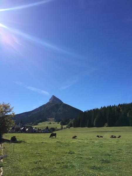
A trail route that winds its way through the village's hamlets via paths and trails. Accessible but never monotonous. Perfect for discovering a classic Winter Trail and Trail Festival route.
The characteristics of the route.
Saint-Pierre-de-Chartreuse (38)
- Distance 14.56 km
- Elevation gain 630 m
- Elevation lost 630 m
- Min. elevation 790 m
- Max. elevation. 1109 m
- Duration (depending on pace) 3h30
- Marking Yes
After an initial stretch through the heart of the Chartreuse forest on the slopes of Roc d'Arguille, you'll discover the expanse of Saint Pierre de Chartreuse, a commune nestled at the foot of Grand Som. The final section takes you into the heart of this valley, offering views of Chamechaude, Charmant Som, Pinéa, and Scia.
Download the Raidlight-Trail-Experience App
Enjoy all the trail routes directly on your smartphone with several useful features:
*Track your real-time location along the route
*Access detailed trail descriptions during your outing and download the data for offline access
*Benefit from detailed IGN maps and add your timing results to the routes.Marking : Trail Marking No. 6 Blue Starting panels are placed in the villages at parking areas or visitor reception points. To follow your route, posts are installed at intersections, identifiable by a plaque indicating the name and altitude. Between the posts, painted markers guide the path, although not always. You may also be guided by small directional signs. A map titled "Promenades et randonnées en Chartreuse" is recommended.Admission fee : Free access.Opening : Open every day. Subject to favorable snow and weather conditions.Step by step description : Starting from Raidlight/Vertical, head towards Perquelin before turning right onto the bridge to enter the forest. At the Bois du Banc signpost, take the trail that climbs behind to reach the road above. When you cross the road, continue to the right towards the hamlet, which you’ll cross before joining a trail that climbs to the Les Antonins post after a slight dip. At the next intersection, Sentier des Ravières, continue straight, and again go straight when you reach the forest track. Follow the same trail according to the markers until the next crossing with the forest track, where the trail continues straight ahead. The clearing known as Lentillère offers a first glimpse of Chamechaude and Charmant Som before plunging back into the heart of the Chartreuse forest. At the direction post Sur Majeure, continue towards Sur Brévardière and proceed straight on a rolling trail. At the direction post La Pérelle, head towards Les Rajaches and then turn right to descend into a valley, enjoying the view of the hamlet of Garcinière. A short section of road leads you to a trail on your left, bringing you to the post Sur les Epallets. A beautiful but brief climb awaits you until you reach the direction post Le Clot, where you can enjoy a stunning view of the valley with Grand Som at the summit of the ski lifts at Les Egaux. Next, take a long forest track that leads you to Cherlieu, which you will cross in the direction of the direction post Cherlieu-Calvaire for a pleasant downhill section for your legs. You’ll need to power up again to reach the hamlet of Les Egaux, which you’ll cross until you find yourself at the base of the ski lifts. Continue left on the road, then right onto the departmental road, before heading left onto the trail that offers a unique view of Saint Hugues de Chartreuse and the surrounding mountains. At the Ancienne Route de Chartreuse post, continue right to join the departmental road and pass by the church of the hamlet, which has been the Arcabas Museum in Chartreuse since 1952 (feel free to push the entrance door or come back later). Then, take the trail on the left across the Flin plateau, which becomes cross-country ski trails in winter, and descend to the Pont de la Ravelle, crossing it before climbing up to La Martinière. After crossing the departmental road, continue straight on a small road to reach the direction post La Martinière. Turn right alongside the building to find the forest that will lead you to La Diat. In the hamlet of La Diat, stay on the same bank of the stream to reach the tennis courts, then continue on the road before turning right onto the Pont Routier de la Dame and reaching an intersection. At the intersection in La Diat, turn right to cross the bridge and continue on the trail to the left towards the Pont de la Laiterie. At the PDIPR post, head towards the village, and after going around the building on the left, you will find yourself at the town hall square. Turning right will bring you back to Raidlight.
Area : Cœur de Chartreuse
Report a problem
Website Pdf file Features of the application :
- Location and orientation on detailed maps thanks to the GPS of your smartphone
- Description of routes and points of interest on the route
- Photo gallery by route
- Detailed elevation profile
- Route tracking alert to warn you if you stray from the route
- Send predefined messages by SMS to your contacts
- Emergency module: trigger a call or send an emergency SMS in case of problem
- Agenda: access to events organized in the department
- News: find in the application the latest news on the web portal
- Adding achievements
- Add reports in case of problems encountered on the routes
- Share on social networks
Add your time and share your feelings
Services nearby

Coeur de Chartreuse Tourist Information center at Saint Pierre de Chartreuse
Saint-Pierre-de-Chartreuse

Museum of Contemporary Sacred Art
Saint-Pierre-de-Chartreuse

Location de matériel au foyer de ski de fond
Saint-Pierre-de-Chartreuse
Museum of la Grande Chartreuse
Saint-Pierre-de-Chartreuse

Espace naturel sensible du col du Coq
Plateau des Petites Roches


Information updated on 2026-01-21 by Chartreuse Tourisme


Follow us on
the digital trails
the digital trails


![]()
The Isère Outdoor application was created
by the Département de l'Isère
Infos & contact
Conseil départemental de l'Isère
7 rue Fantin Latour
CS 41096
38 022 Grenoble cedex 1
Tel. 04 76 00 38 38
 Isère Outdoor - Parcours - 6 - Le Tour des Hameaux on trail
Hello, world! This is a toast message.
Isère Outdoor - Parcours - 6 - Le Tour des Hameaux on trail
Hello, world! This is a toast message.
Isère Outdoor - Parcours - 6 - Le Tour des Hameaux on trail
Hello, world! This is a toast message.


OK
Annuler