Rif Bruyant lakes
Add to my favorites

Caution! Zone of vigilance near the route
Le Coiro - du 15/06/2026 au 15/10/2026 In progress
Le Sappey - du 15/06/2026 au 30/09/2026 In progress
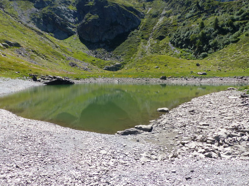
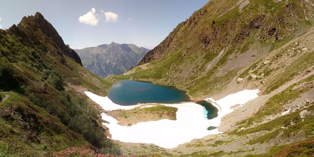
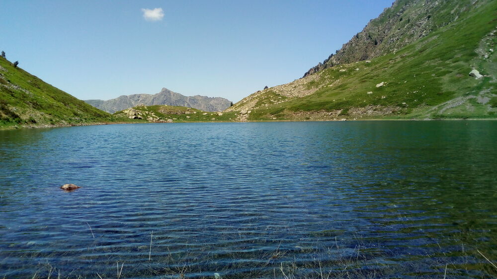
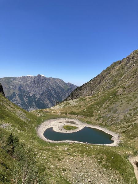
A challenging and fairly demanding hike that will take you from the Roizonne Valley up to the high-altitude lake of Rif Bruyant. Along the way, you’ll pass through the hamlet and the Rif Bruyant refuge, following the course of this mountain stream.
The characteristics of the route.

Lavaldens (38)
- Distance 12.9 km
- Elevation gain 1050 m
- Elevation lost 1050 m
- Min. elevation 981 m
- Max. elevation. 2023 m
- Duration (depending on pace) 5h30
- Marking Yes
A challenging hike through stunning landscapes, from the Roizonne Valley to the high-altitude lake of Rif Bruyant
Accompanied by the stream all along the way, you’ll cross a surprisingly diverse range of landscapes as you ascend: The hamlet of Rif Bruyant, with architecture typical of the valley and meadows bordered by “clapiers” (stone piles from field clearing), Then the cirque where the lake lies nestled, And finally, breathtaking views on the way back.
Route:
Start from the Mollard parking area.
Follow the small road to the heart of the hamlet, then continue on the path toward the Rif Bruyant valley.
Ignore the path on your right heading to La Rochette and continue straight until you reach the Rif Bruyant farms. Walk through them; the path narrows into a trail between two dry-stone walls.
Continue uphill through the woods and into the cirque, just after crossing a dry streambed—take care not to lose the trail here.
Cross the meadows (abundant orange lilies and martagon lilies), then rejoin the path that winds through the forest in several switchbacks. Cross the stream once more and enter the woods where you'll find a charming forest cabin.
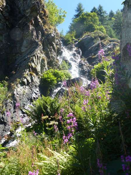
At the signpost indicating the lake, take the left-hand trail, which follows a forest balcony path leading up to the lake's outlet. As you climb among the rocks, don’t miss the bridal veil waterfall on your right.
Return:
You can return via the same route or continue up to the col (mountain pass) by following the trail on the right. The descent is via long switchbacks.
Important!
You are in a protected natural area. Please:
- Stay on the marked trails
- Keep your dog on a leash
- Do not light fires
- Take your trash with you or dispose of it in the nearest bins
- Preserving this environment is vital!
- For swimming, please use the designated lake at the Alpe du Grand Serre resort.Equipments : Car park, Admission fee : Free access.Opening : From 15/06 to 15/10 daily. Subject to favorable weather.
Accompanied by the stream all along the way, you’ll cross a surprisingly diverse range of landscapes as you ascend: The hamlet of Rif Bruyant, with architecture typical of the valley and meadows bordered by “clapiers” (stone piles from field clearing), Then the cirque where the lake lies nestled, And finally, breathtaking views on the way back.
Route:
Start from the Mollard parking area.
Follow the small road to the heart of the hamlet, then continue on the path toward the Rif Bruyant valley.
Ignore the path on your right heading to La Rochette and continue straight until you reach the Rif Bruyant farms. Walk through them; the path narrows into a trail between two dry-stone walls.
Continue uphill through the woods and into the cirque, just after crossing a dry streambed—take care not to lose the trail here.
Cross the meadows (abundant orange lilies and martagon lilies), then rejoin the path that winds through the forest in several switchbacks. Cross the stream once more and enter the woods where you'll find a charming forest cabin.
At the signpost indicating the lake, take the left-hand trail, which follows a forest balcony path leading up to the lake's outlet. As you climb among the rocks, don’t miss the bridal veil waterfall on your right.
Return:
You can return via the same route or continue up to the col (mountain pass) by following the trail on the right. The descent is via long switchbacks.
Important!
You are in a protected natural area. Please:
- Stay on the marked trails
- Keep your dog on a leash
- Do not light fires
- Take your trash with you or dispose of it in the nearest bins
- Preserving this environment is vital!
- For swimming, please use the designated lake at the Alpe du Grand Serre resort.Equipments : Car park, Admission fee : Free access.Opening : From 15/06 to 15/10 daily. Subject to favorable weather.
Area : Matheysine
Report a problem
Website TOPO_Le Lac de Rif Bruyant Features of the application :
- Location and orientation on detailed maps thanks to the GPS of your smartphone
- Description of routes and points of interest on the route
- Photo gallery by route
- Detailed elevation profile
- Route tracking alert to warn you if you stray from the route
- Send predefined messages by SMS to your contacts
- Emergency module: trigger a call or send an emergency SMS in case of problem
- Agenda: access to events organized in the department
- News: find in the application the latest news on the web portal
- Adding achievements
- Add reports in case of problems encountered on the routes
- Share on social networks
Add your time and share your feelings
Services nearby

Alpe du Grand Serre Tourist Office
Alpe Du Grand Serre

Belvédère Olivier Messiaen
Saint-Théoffrey

Foyer de ski de fond du Col d'Ornon
Chantelouve

Museum "Musée Matheysin"
La Mure
Musuem "La Mine Image"
La Motte-d'Aveillans


Information updated on 2025-09-21 by Matheysine Tourisme


Follow us on
the digital trails
the digital trails


![]()
The Isère Outdoor application was created
by the Département de l'Isère
Infos & contact
Conseil départemental de l'Isère
7 rue Fantin Latour
CS 41096
38 022 Grenoble cedex 1
Tel. 04 76 00 38 38
 Isère Outdoor - Parcours - Rif Bruyant lakes
Hello, world! This is a toast message.
Isère Outdoor - Parcours - Rif Bruyant lakes
Hello, world! This is a toast message.
Isère Outdoor - Parcours - Rif Bruyant lakes
Hello, world! This is a toast message.


OK
Annuler