Arselle plateau - Achard lake
Add to my favorites

Departure point: Plateau de l'Arselle reception hall - Chamrousse 1600.
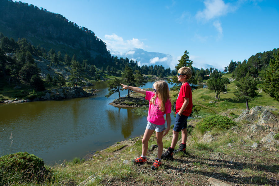
Before you start your walk, take a moment to stop and enjoy the scenery.
For the round trip, allow 2h45 (5.4km).
The characteristics of the route.

Chamrousse (38)
- Distance 5.46 km
- Elevation gain 290 m
- Elevation lost 290 m
- Min. elevation 1636 m
- Max. elevation. 1924 m
- Duration (depending on pace) 1h45
- Marking Yes
The itinerary begins gently, taking in the Nordic ski trails before heading deep into the forest and beginning the ascent to Lake Achard.
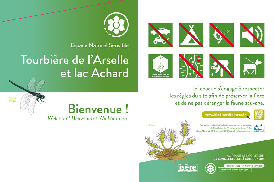
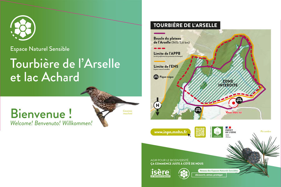
? Warning: the Arselle plateau is a protected area (peat bog classified APPB - Arrêtés Préfectoraux de Protection Biotope), so there are a few rules to observe to help protect it. Fires, wild camping, picking and dumping waste are strictly forbidden, and bivouacs are prohibited during the peak season between early May and late October. Please stay on the path that circles the area, as it is forbidden to go onto the plateau in order to preserve the fragile environment.
? The little extra: the "hiking star" summer medal for children!
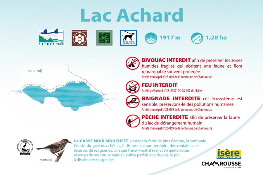
On presentation of a photo taken at the hiking site, brave little hikers will be awarded a named diploma + possible purchase of the "lac Achard" silver star to hang proudly on the backpack (on sale for €3 at Tourist Offices).Marking : Yellow and green signs (PR)Equipments : Public WC, Good plans : Discovery of the flora, panoramic viewsDelicate passages : Some rocky and muddy passages in the peatbog. We advise you not to take this path down by wet weather (it can be slippery).Admission fee : Free access.Opening : From 15/06 to 01/10 daily. Subject to snow conditions.Warning : Achard lake natural site: peak season (May to October). Specific regulations by municipal by-law: fire, wood gathering, camping, gathering, fishing and swimming (even for dogs) are strictly forbidden (subject to fines). Dogs must be kept on a leash.
? Warning: the Arselle plateau is a protected area (peat bog classified APPB - Arrêtés Préfectoraux de Protection Biotope), so there are a few rules to observe to help protect it. Fires, wild camping, picking and dumping waste are strictly forbidden, and bivouacs are prohibited during the peak season between early May and late October. Please stay on the path that circles the area, as it is forbidden to go onto the plateau in order to preserve the fragile environment.
? The little extra: the "hiking star" summer medal for children!
On presentation of a photo taken at the hiking site, brave little hikers will be awarded a named diploma + possible purchase of the "lac Achard" silver star to hang proudly on the backpack (on sale for €3 at Tourist Offices).Marking : Yellow and green signs (PR)Equipments : Public WC, Good plans : Discovery of the flora, panoramic viewsDelicate passages : Some rocky and muddy passages in the peatbog. We advise you not to take this path down by wet weather (it can be slippery).Admission fee : Free access.Opening : From 15/06 to 01/10 daily. Subject to snow conditions.Warning : Achard lake natural site: peak season (May to October). Specific regulations by municipal by-law: fire, wood gathering, camping, gathering, fishing and swimming (even for dogs) are strictly forbidden (subject to fines). Dogs must be kept on a leash.
Area : Grésivaudan
Report a problem
Website Arselle plateau - Achard lake hiking path track Chamrousse Achard lake municipal by-law Features of the application :
- Location and orientation on detailed maps thanks to the GPS of your smartphone
- Description of routes and points of interest on the route
- Photo gallery by route
- Detailed elevation profile
- Route tracking alert to warn you if you stray from the route
- Send predefined messages by SMS to your contacts
- Emergency module: trigger a call or send an emergency SMS in case of problem
- Agenda: access to events organized in the department
- News: find in the application the latest news on the web portal
- Adding achievements
- Add reports in case of problems encountered on the routes
- Share on social networks
meunomeecris
finished in 02:50:00
The 2024/06/02
En savoir plus
Ajouter votre chrono et partager vos sensations
2024/06/02 02:50:00
meunomeecris
meunomeecris
2024/06/02 02:50:00
meunomeecris
meunomeecris
Services nearby

Arselle Peatbog (Preserved Natural Area)
Chamrousse

Romanche Museum
Livet-et-Gavet

Chamrousse Tourist Office
Chamrousse
Office Thermal et Touristique d'Uriage-les-Bains
Saint-Martin-d'Uriage

Taillefer Hut
Oulles


Information updated on 2026-05-29 by Office du Tourisme de Chamrousse


Follow us on
the digital trails
the digital trails


![]()
The Isère Outdoor application was created
by the Département de l'Isère
Infos & contact
Conseil départemental de l'Isère
7 rue Fantin Latour
CS 41096
38 022 Grenoble cedex 1
Tel. 04 76 00 38 38
 Isère Outdoor - Parcours - Arselle plateau - Achard lake
Hello, world! This is a toast message.
Isère Outdoor - Parcours - Arselle plateau - Achard lake
Hello, world! This is a toast message.
Isère Outdoor - Parcours - Arselle plateau - Achard lake
Hello, world! This is a toast message.


OK
Annuler