Hiking without a car - The Oursière waterfall and the Robert lakes
Add to my favorites

Caution! Zone of vigilance near the route
Bouquetin des Alpes - du 01/06/2026 au 30/09/2026 In progress
Bouquetin des Alpes - du 01/06/2026 au 30/09/2026 In progress
Bouquetin des Alpes - du 01/06/2026 au 30/09/2026 In progress
Bouquetin des Alpes - du 01/06/2026 au 30/09/2026 In progress
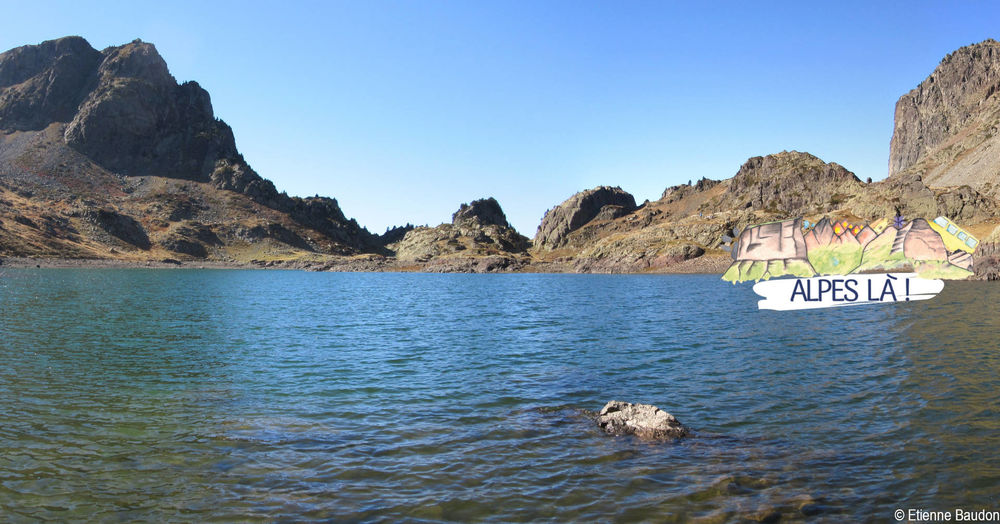
A hike along the water between waterfalls and lakes in the mineral universe of Belledonne.
Itinerary with public transport proposed by Alpes Là.
The characteristics of the route.

Chamrousse (38)
- Distance 11.5 km
- Elevation gain 1150 m
- Elevation lost 540 m
- Min. elevation 1034 m
- Max. elevation. 2045 m
- Duration (depending on pace) 5h30
- Marking Yes
Start : Les Seiglières (1065 m) - 2 h (4.6 km, D+ 458 m, D- 63 m)
From the stop, cross the road to reach the parking lot, start on the marked path (direction east) towards the Cascade de l'Oursière.
The itinerary goes through the forest, goes down to reach the Etang des Marais Chauds and then the crossing of Marais Chaud. Then take the path going up south-east. At Pierre Molle, take the Gâtte road on the left and then the bridge over the Pourrettes stream. The path crosses always in forest, intersects 2 scree slopes and their brooks, until reaching the waterfall of Oursière.
1) Cascade de l'Oursière (1472 m) - 1 h 25 (1.9 km, D+ 457 m)
Go up in the forest by well traced but rather steep laces until you reach a flat area where you discover the different meanders of the Doménons stream. At the Oursière, choose the path towards the Robert Lakes, which then moves away from the river bed. Go up the slope lined with shrubs (alders) until you reach a new flat to the south where you meet the GR738®.
2) (under) Le Grand Sorbier (1928m) - 20 min (0.8 km, D+ 88 m, D- 14 m)
Continue in the valley south on the GR738® trail and discover the first Roberts lakes.
3) Robert Lakes - Brèche Robert Nord (2050m) - 45 min (1.9 km, D+ 48 m, D- 295 m)
Continue on the GR® by the north of the lake to reach the Brèche Robert Nord, then go down in the combe to the Lac des Pourettes. 500 m after the lake, we reach the crossroads La Grande Aiguille (itinerary variation towards Casserousse possible from this point).
4) (under) La Grande Aiguille (1762m) - 45 min (2.1 km, D+ 78 m, D- 167 m)
Always go down by the GR738® to join the slopes of the Chamrousse resort and the Recoin snow front at the Aiguille ski lift.
Back to the resort: Chamrousse 1650 (Le Recoin)
A hike possible without a car where you can take the bus to and from. Make sure you know the time and day of traffic before you leave.Marking : This route is marked with yellow signs and yellow paint (PR) and red and white (GR).Equipments : Parking nearby, Delicate passages : The itinerary crosses a Natura 2000 zone, and the Sensitive Natural Area (ENS) of Seiglières and Marais Chaud, natural environments to be preserved.Admission fee : Free access. Public transport ticket price at your expense.Opening : From 15/06 to 31/10 daily. Hike to do in summer season, presence of late snow.
From the stop, cross the road to reach the parking lot, start on the marked path (direction east) towards the Cascade de l'Oursière.
The itinerary goes through the forest, goes down to reach the Etang des Marais Chauds and then the crossing of Marais Chaud. Then take the path going up south-east. At Pierre Molle, take the Gâtte road on the left and then the bridge over the Pourrettes stream. The path crosses always in forest, intersects 2 scree slopes and their brooks, until reaching the waterfall of Oursière.
1) Cascade de l'Oursière (1472 m) - 1 h 25 (1.9 km, D+ 457 m)
Go up in the forest by well traced but rather steep laces until you reach a flat area where you discover the different meanders of the Doménons stream. At the Oursière, choose the path towards the Robert Lakes, which then moves away from the river bed. Go up the slope lined with shrubs (alders) until you reach a new flat to the south where you meet the GR738®.
2) (under) Le Grand Sorbier (1928m) - 20 min (0.8 km, D+ 88 m, D- 14 m)
Continue in the valley south on the GR738® trail and discover the first Roberts lakes.
3) Robert Lakes - Brèche Robert Nord (2050m) - 45 min (1.9 km, D+ 48 m, D- 295 m)
Continue on the GR® by the north of the lake to reach the Brèche Robert Nord, then go down in the combe to the Lac des Pourettes. 500 m after the lake, we reach the crossroads La Grande Aiguille (itinerary variation towards Casserousse possible from this point).
4) (under) La Grande Aiguille (1762m) - 45 min (2.1 km, D+ 78 m, D- 167 m)
Always go down by the GR738® to join the slopes of the Chamrousse resort and the Recoin snow front at the Aiguille ski lift.
Back to the resort: Chamrousse 1650 (Le Recoin)
A hike possible without a car where you can take the bus to and from. Make sure you know the time and day of traffic before you leave.Marking : This route is marked with yellow signs and yellow paint (PR) and red and white (GR).Equipments : Parking nearby, Delicate passages : The itinerary crosses a Natura 2000 zone, and the Sensitive Natural Area (ENS) of Seiglières and Marais Chaud, natural environments to be preserved.Admission fee : Free access. Public transport ticket price at your expense.Opening : From 15/06 to 31/10 daily. Hike to do in summer season, presence of late snow.
Area : Grésivaudan
Report a problem
Website Oursière waterfall and Robert lakes topoguide Features of the application :
- Location and orientation on detailed maps thanks to the GPS of your smartphone
- Description of routes and points of interest on the route
- Photo gallery by route
- Detailed elevation profile
- Route tracking alert to warn you if you stray from the route
- Send predefined messages by SMS to your contacts
- Emergency module: trigger a call or send an emergency SMS in case of problem
- Agenda: access to events organized in the department
- News: find in the application the latest news on the web portal
- Adding achievements
- Add reports in case of problems encountered on the routes
- Share on social networks
Add your time and share your feelings
Services nearby

Chamrousse Tourist Office
Chamrousse
Uriage-les-Bains Tourist Information Office
Saint-Martin-d'Uriage

Refuge de la Pra
Revel

Arselle Peatbog (Preserved Natural Area)
Chamrousse
Gîte d'Alpage Le Pré du Mollard
La Combe-de-Lancey




Follow us on
the digital trails
the digital trails





The Isère Outdoor application was created
by the Département de l'Isère
Infos & contact
Conseil départemental de l'Isère
7 rue Fantin Latour
CS 41096
38 022 Grenoble cedex 1
Tel. 04 76 00 38 38
 Isère Outdoor - Parcours - Hiking without a car - The Oursière waterfall and the Robert lakes
Hello, world! This is a toast message.
Isère Outdoor - Parcours - Hiking without a car - The Oursière waterfall and the Robert lakes
Hello, world! This is a toast message.
Isère Outdoor - Parcours - Hiking without a car - The Oursière waterfall and the Robert lakes
Hello, world! This is a toast message.


OK
Annuler