MTB track - Panoramique
Add to my favorites

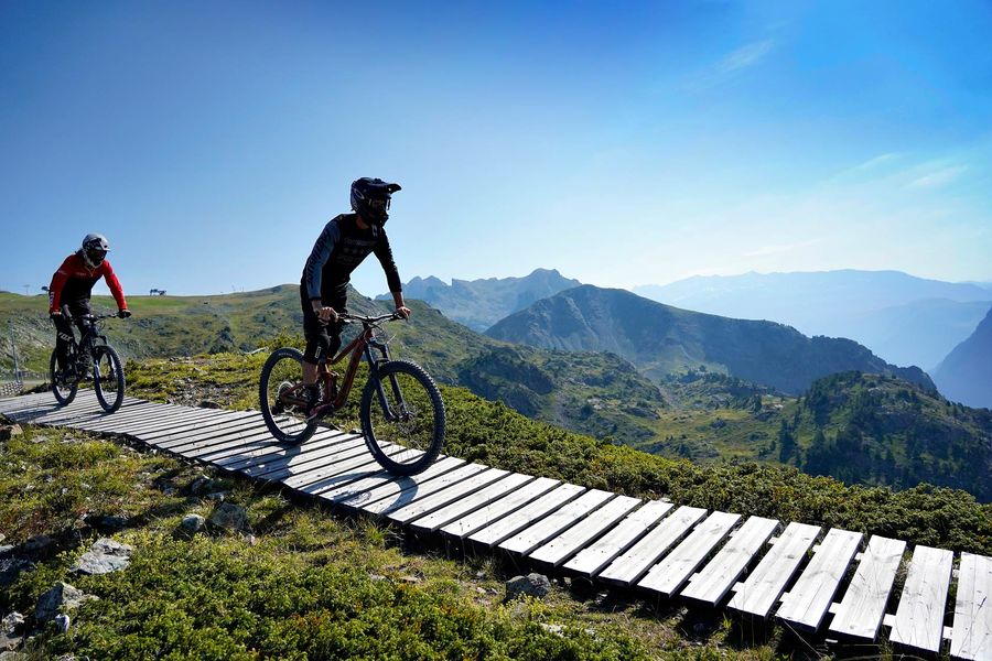
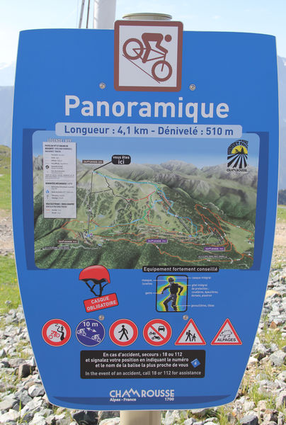
Medium-difficulty downhill mountain bike trail (blue level) at Chamrousse 1750 - Roche Béranger.
Start: top of Bérangère chairlift
Finish: bottom of Bachat-Bouloud chairlift + end of road to Bérangère chairlift.
Duration: 7 minutes
The characteristics of the route.
Chamrousse (38)
- Distance 3.9 km
- Elevation gain 500 m
- Elevation lost 0 m
- Min. elevation 1732 m
- Max. elevation. 2231 m
- Duration (depending on pace) 0h07
- Marking Yes
A slightly more technical trail, with a more demanding enduro-type layout, crossing numerous undergrowths and ending at the Bachat-Bouloud chairlift. The faster you go, the more fun it is.
Downhill machines and scooters are allowed on the blue (and green) runs, where you don't need to take your wheels off the ground.Equipments : Public WC, Parking nearby, Opening : From 01/07 to 31/07. Bérangère chairlift opening times summer 2024: 9.15am-5pm.
Downhill machines and scooters are allowed on the blue (and green) runs, where you don't need to take your wheels off the ground.Equipments : Public WC, Parking nearby, Opening : From 01/07 to 31/07. Bérangère chairlift opening times summer 2024: 9.15am-5pm.
Area : Grésivaudan
Report a problem
Website Features of the application :
- Location and orientation on detailed maps thanks to the GPS of your smartphone
- Description of routes and points of interest on the route
- Photo gallery by route
- Detailed elevation profile
- Route tracking alert to warn you if you stray from the route
- Send predefined messages by SMS to your contacts
- Emergency module: trigger a call or send an emergency SMS in case of problem
- Agenda: access to events organized in the department
- News: find in the application the latest news on the web portal
- Adding achievements
- Add reports in case of problems encountered on the routes
- Share on social networks
Add your time and share your feelings
Services nearby

Arselle Peatbog (Preserved Natural Area)
Chamrousse

Chamrousse Tourist Office
Chamrousse

Romanche Museum
Livet-et-Gavet
Office Thermal et Touristique d'Uriage-les-Bains
Saint-Martin-d'Uriage

Taillefer Hut
Oulles


Information updated on 2024-10-04 by Office du Tourisme de Chamrousse


Follow us on
the digital trails
the digital trails


![]()
The Isère Outdoor application was created
by the Département de l'Isère
Infos & contact
Conseil départemental de l'Isère
7 rue Fantin Latour
CS 41096
38 022 Grenoble cedex 1
Tel. 04 76 00 38 38
 Isère Outdoor - Parcours - MTB track - Panoramique
Hello, world! This is a toast message.
Isère Outdoor - Parcours - MTB track - Panoramique
Hello, world! This is a toast message.
Isère Outdoor - Parcours - MTB track - Panoramique
Hello, world! This is a toast message.


OK
Annuler