Ski-touring ascent route: new starting point at the Bachat-Bouloud Bridge – Croix de Chamrousse – un
Add to my favorites


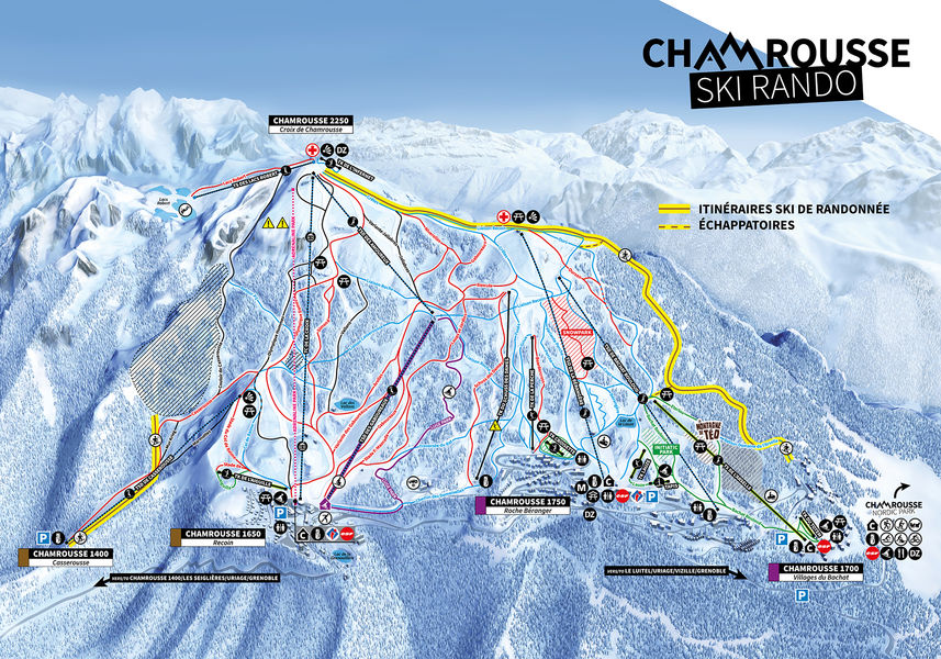
Challenging ski touring ascent to La Croix, approx. 3.5 km and 630 m ascent.
⚠ New starting point: Pont de Bachat: put on your skis at the Ecrin chairlift, then join the other side of the piste.
The characteristics of the route.

Chamrousse (38)
- Distance 3.68 km
- Elevation gain 530 m
- Elevation lost 0 m
- Min. elevation 1724 m
- Max. elevation. 2246 m
- Duration (depending on pace) 2h30
- Marking Yes
Possible descent via downhill ski slopes (red or blue level).
Mainly forest and alpine route from the Bachat-Bouloud bridge.
Two escape routes are possible, one close to the Ours and the other close to the Crêtes alpine slopes. Conversion not compulsory but strongly recommended.
Tip: discover On Piste, an application and website to help you prepare and organize your ski touring outing or holiday, and track down the best addresses and events in sports destinations!Marking : Purple sign with ski touring pictogram and marker number.Delicate passages : Common itinerary with snowshoeing.Admission fee : Free access. Hiker" pass valid for 1 trip on 2 of the 3 lifts: Casserousse chairlift, La Croix gondola or Lacs Robert chairlift (for the Vans circuit, for example). Rates winter 2024-25 : - Adult / Senior : €13 - Child / Youth / Student: €10 - Senior Plus : 7€.Opening : From 02/12 to 14/04 daily between 8.30 am and 6 pm. ? Do not go down the alpine ski slopes at night - danger damage winch with cable from 6pm to 8.30am. Subject to favorable snow and weather conditions.
Mainly forest and alpine route from the Bachat-Bouloud bridge.
Two escape routes are possible, one close to the Ours and the other close to the Crêtes alpine slopes. Conversion not compulsory but strongly recommended.
Tip: discover On Piste, an application and website to help you prepare and organize your ski touring outing or holiday, and track down the best addresses and events in sports destinations!Marking : Purple sign with ski touring pictogram and marker number.Delicate passages : Common itinerary with snowshoeing.Admission fee : Free access. Hiker" pass valid for 1 trip on 2 of the 3 lifts: Casserousse chairlift, La Croix gondola or Lacs Robert chairlift (for the Vans circuit, for example). Rates winter 2024-25 : - Adult / Senior : €13 - Child / Youth / Student: €10 - Senior Plus : 7€.Opening : From 02/12 to 14/04 daily between 8.30 am and 6 pm. ? Do not go down the alpine ski slopes at night - danger damage winch with cable from 6pm to 8.30am. Subject to favorable snow and weather conditions.
Read before you go!
Free parking on route de Bachat-Bouloud or recommended 800/900 meters away on avenue du père Tasse.
Free parking on route de Bachat-Bouloud or recommended 800/900 meters away on avenue du père Tasse.
Area : Grésivaudan
Report a problem
Website Ski touring route Bachat-Bouloud - Croix de Chamrousse - non secured Features of the application :
- Location and orientation on detailed maps thanks to the GPS of your smartphone
- Description of routes and points of interest on the route
- Photo gallery by route
- Detailed elevation profile
- Route tracking alert to warn you if you stray from the route
- Send predefined messages by SMS to your contacts
- Emergency module: trigger a call or send an emergency SMS in case of problem
- Agenda: access to events organized in the department
- News: find in the application the latest news on the web portal
- Adding achievements
- Add reports in case of problems encountered on the routes
- Share on social networks
Add your time and share your feelings
Services nearby

Arselle Peatbog (Preserved Natural Area)
Chamrousse

Chamrousse Tourist Office
Chamrousse

Romanche Museum
Livet-et-Gavet
Uriage-les-Bains Tourist Information Office
Saint-Martin-d'Uriage

Taillefer Hut
Oulles


Information updated on 2026-09-21 by Office du Tourisme de Chamrousse


Follow us on
the digital trails
the digital trails





The Isère Outdoor application was created
by the Département de l'Isère
Infos & contact
Conseil départemental de l'Isère
7 rue Fantin Latour
CS 41096
38 022 Grenoble cedex 1
Tel. 04 76 00 38 38
 Isère Outdoor - Parcours - Ski-touring ascent route: new starting point at the Bachat-Bouloud Bridge – Croix de Chamrousse – un
Hello, world! This is a toast message.
Isère Outdoor - Parcours - Ski-touring ascent route: new starting point at the Bachat-Bouloud Bridge – Croix de Chamrousse – un
Hello, world! This is a toast message.
Isère Outdoor - Parcours - Ski-touring ascent route: new starting point at the Bachat-Bouloud Bridge – Croix de Chamrousse – un
Hello, world! This is a toast message.


OK
Annuler