Les Ramées, snowshoe route
Add to my favorites

Caution! Zone of vigilance near the route
Moucherotte / Les Ramées - du 08/08/2026 au 11/10/2026 Upcoming
La Sierre - du 14/09/2026 au 25/10/2026 Upcoming
Stade de Neige - du 11/10/2026 au 31/10/2026 Upcoming
Les Ramées / Stade de neige - du 27/09/2026 au 31/10/2026 Upcoming
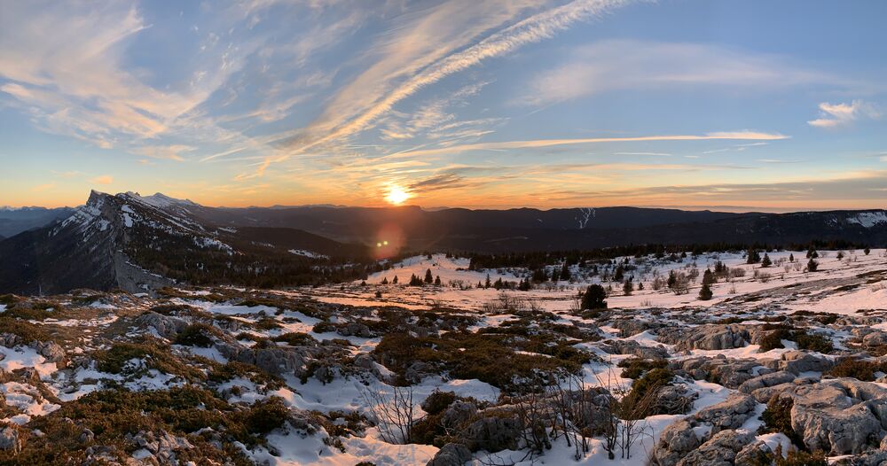
From the Montagnes de Lans car park, a path alternates between undergrowth and clear views. You will cross the Plateau des Ramées, where you will have a magnificent view of the Grenoble valley and the Lans-en-Vercors mountain range.
The characteristics of the route.
Lans-en-Vercors (38)
- Distance 6.7 km
- Elevation gain 290 m
- Elevation lost 290 m
- Min. elevation 1366 m
- Max. elevation. 1649 m
- Duration (depending on pace) 2h30
- Marking Yes
Equipments : Public WC, Parking nearby, Admission fee : Free access.Opening : From 19/12 to 31/03 daily.
Subject to snow conditions.
Area : Massif du Vercors
Report a problem
Website Features of the application :
- Location and orientation on detailed maps thanks to the GPS of your smartphone
- Description of routes and points of interest on the route
- Photo gallery by route
- Detailed elevation profile
- Route tracking alert to warn you if you stray from the route
- Send predefined messages by SMS to your contacts
- Emergency module: trigger a call or send an emergency SMS in case of problem
- Agenda: access to events organized in the department
- News: find in the application the latest news on the web portal
- Adding achievements
- Add reports in case of problems encountered on the routes
- Share on social networks
Add your time and share your feelings
Services nearby

Auberge des Allières
Lans-en-Vercors

OTI Vercors - Bureau d'information touristique de Lans en Vercors
Lans-en-Vercors

Espace naturel sensible de la tourbière du Peuil
Claix
Gite d'alpage de la Molière
Engins

Foyer de ski de fond de Méaudre
Autrans-Méaudre en Vercors


Information updated on 2026-02-10 by Office de Tourisme Intercommunal du Vercors


Follow us on
the digital trails
the digital trails


![]()
The Isère Outdoor application was created
by the Département de l'Isère
Infos & contact
Conseil départemental de l'Isère
7 rue Fantin Latour
CS 41096
38 022 Grenoble cedex 1
Tel. 04 76 00 38 38
 Isère Outdoor - Parcours - Les Ramées, snowshoe route
Hello, world! This is a toast message.
Isère Outdoor - Parcours - Les Ramées, snowshoe route
Hello, world! This is a toast message.
Isère Outdoor - Parcours - Les Ramées, snowshoe route
Hello, world! This is a toast message.


OK
Annuler