Cascades de l'Alloix
Add to my favorites

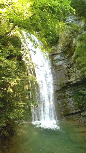
A short hike with a more challenging option to explore the waterfalls along the Alloix Stream. The trail winds back and forth across the stream, crossing small wooden bridges along the way.
The characteristics of the route.

Saint-Vincent-de-Mercuze (38)
- Distance 3.2 km
- Elevation gain 160 m
- Elevation lost 160 m
- Min. elevation 322 m
- Max. elevation. 469 m
- Duration (depending on pace) 1h15
- Marking Yes
The Alloix Stream is dotted with a series of small waterfalls, rapids, pools (“gouilles” in the local dialect), and, of course, waterfalls—the most impressive of which is the Grande Cascade, over 30 m high, which overlooks the trail.
Start - Finish: elevation 350 m.
Community center / swimming pool parking lot.
Hike duration: 45 min.
Route:
From the Saint-Vincent community center, head toward the Alloix Waterfalls as you approach the roundabout; turn left and go up Rue de la Vieille Eglise, then turn right onto Rue de la Croix Blanche. Continue straight ahead until you reach the “Ancienne Voie de Tramway” intersection; turn left toward the Alloix Waterfall. At the “Torrent d’Alloix” intersection, turn right and take the trail that runs alongside the stream to reach “Ancienne Place Charbonnière.” From there, turn left to head to the Cascade de la Gouille Michel.
The return to Saint-Vincent goes through Ancienne Place Charbonnière, the Chemin des Cascades, and then the hamlet of Montalieu to reach the Ancienne Voie du Tramway intersection. From there, return to the Saint-Vincent community center via the same route.Marking : Signpost for the Chartreuse Regional Nature Park.Delicate passages : The trail is narrow. It can be slippery when wet.Admission fee : Free access.Opening : All year round daily. Subject to favorable weather.
Start - Finish: elevation 350 m.
Community center / swimming pool parking lot.
Hike duration: 45 min.
Route:
From the Saint-Vincent community center, head toward the Alloix Waterfalls as you approach the roundabout; turn left and go up Rue de la Vieille Eglise, then turn right onto Rue de la Croix Blanche. Continue straight ahead until you reach the “Ancienne Voie de Tramway” intersection; turn left toward the Alloix Waterfall. At the “Torrent d’Alloix” intersection, turn right and take the trail that runs alongside the stream to reach “Ancienne Place Charbonnière.” From there, turn left to head to the Cascade de la Gouille Michel.
The return to Saint-Vincent goes through Ancienne Place Charbonnière, the Chemin des Cascades, and then the hamlet of Montalieu to reach the Ancienne Voie du Tramway intersection. From there, return to the Saint-Vincent community center via the same route.Marking : Signpost for the Chartreuse Regional Nature Park.Delicate passages : The trail is narrow. It can be slippery when wet.Admission fee : Free access.Opening : All year round daily. Subject to favorable weather.
Area : Grésivaudan
Report a problem
Pdf file Features of the application :
- Location and orientation on detailed maps thanks to the GPS of your smartphone
- Description of routes and points of interest on the route
- Photo gallery by route
- Detailed elevation profile
- Route tracking alert to warn you if you stray from the route
- Send predefined messages by SMS to your contacts
- Emergency module: trigger a call or send an emergency SMS in case of problem
- Agenda: access to events organized in the department
- News: find in the application the latest news on the web portal
- Adding achievements
- Add reports in case of problems encountered on the routes
- Share on social networks

Kouips38
The 2022/04/16
En savoir plus
Ajouter votre chrono et partager vos sensations
2022/04/16 Kouips38
C’est conseillé en très forte chaleur, toute la montée est ombragée, c’est le top! Par contre trop de gens en petite basket, il faut une bonne semelle car parfois le sentier est raide.
2022/04/16 Kouips38
C’est conseillé en très forte chaleur, toute la montée est ombragée, c’est le top! Par contre trop de gens en petite basket, il faut une bonne semelle car parfois le sentier est raide.
Services nearby

Bureau d'information Touristique Pontcharra
Pontcharra

Foyer de ski de fond du Barioz
Crêts en Belledonne
Coeur de Chartreuse Tourist Information center at Saint Pierre d'Entremont
Saint-Pierre-d'Entremont
Les Petites Roches Tourist Information Office
Plateau des Petites Roches
Allevard Tourist Information Office events department
Allevard


Information updated on 2026-08-24 by Office de Tourisme de Belledonne Chartreuse


Follow us on
the digital trails
the digital trails





The Isère Outdoor application was created
by the Département de l'Isère
Infos & contact
Conseil départemental de l'Isère
7 rue Fantin Latour
CS 41096
38 022 Grenoble cedex 1
Tel. 04 76 00 38 38
 Isère Outdoor - Parcours - Cascades de l'Alloix
Hello, world! This is a toast message.
Isère Outdoor - Parcours - Cascades de l'Alloix
Hello, world! This is a toast message.
Isère Outdoor - Parcours - Cascades de l'Alloix
Hello, world! This is a toast message.


OK
Annuler