The forest of Combeloup from Murianette
Add to my favorites

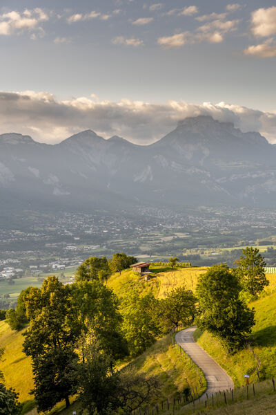
A walk that starts at the bottom of the Grésivaudan valley. The streams and resurgences are numerous, offering a little freshness to this walk in the forest.
The characteristics of the route.

Murianette (38)
- Distance 10.6 km
- Elevation gain 650 m
- Elevation lost 650 m
- Min. elevation 223 m
- Max. elevation. 680 m
- Duration (depending on pace) 4h25
- Marking Yes
Equipments : Car park, Admission fee : Free of chargeOpening : Throughout the year : open daily.Step by step description : From the Murianette hiking sign (alt. 223 m), take the road towards the hamlet of Murianette, the "Montée du champ de la vigne", following the yellow markers. Pass the Mairie (town hall) and continue straight ahead, before turning left towards La Tour on the "Chemin de l'Église", above a large bourgeois house. Still on the road, take the "montée de la Tour", and at the first hairpin bend, continue straight ahead to leave the asphalt. Go up the track to reach, on your left, a gully as far as the Roujard fork (alt. 405 m), where you continue to climb to the right towards La Pérérée. Slightly higher up, the path crosses over the Rivet stream to its right bank. After a steep stretch of track, just before reaching the road, you come to the Les Charmettes intersection (alt. 510 m). Take the track to the right towards Les Combes. This descends a little to cross the left bank of the Rivet stream again, and reach the road. Turn left for 20 m to reach Les Combes (alt. 511 m). Take the road to the right, the "chemin de Combeloup", towards the Combeloup forest (2.52 km). Continue on the asphalt to its terminus at the Combeloup farm, with the Venon oak in view. The road becomes a track again and, above the meadows, reaches a fork where you continue to the left, still heading for the Combeloup and Pressembois forest. In the forest, you go around a first combe to reach a ridge. The path then descends to the right. After crossing several streams, you come to the wide crossroads of the Combeloup forest (alt. 672 m). Turn right towards Pressembois. Keep going straight downhill until you reach the Route de Venon, which you follow to the left for 100 m to reach Pressembois. At the signpost, turn right onto the path leading to Champ Duret, 2.2 km away. After a good descent and a slightly uphill crossing, you emerge from the forest. Turn right towards Murianette. The trail crosses back again, this time heading north. Follow it and, as it begins to climb again, turn left onto a narrower path. A steeper section brings you back to the first houses and the Pisse-Vieille stream. Below the flood barrier, turn right up the right bank of the stream to continue towards the hamlet of Murianette. At the road, continue on the opposite side of the road, then, at the Tarrin crossroads (alt. 300 m), turn left to descend to Murianette village and, back on the road, return to your starting point.
Point of interest :
- View of the Chêne de Venon and Grenoble
- The Rivet stream
- State forest
- Combeloup farm
Area : Grenoble-Alpes Métropole
Report a problem
Website Pdf file Features of the application :
- Location and orientation on detailed maps thanks to the GPS of your smartphone
- Description of routes and points of interest on the route
- Photo gallery by route
- Detailed elevation profile
- Route tracking alert to warn you if you stray from the route
- Send predefined messages by SMS to your contacts
- Emergency module: trigger a call or send an emergency SMS in case of problem
- Agenda: access to events organized in the department
- News: find in the application the latest news on the web portal
- Adding achievements
- Add reports in case of problems encountered on the routes
- Share on social networks
Add your time and share your feelings
Services nearby

Espace naturel sensible du Bois de la Batie
Saint-Ismier

Musée Hébert
La Tronche

Office Thermal et Touristique d'Uriage-les-Bains
Saint-Martin-d'Uriage
Medical science museum of Grenoble
La Tronche
Resistance Museum
Grenoble


Information updated on 2025-05-06 by Office de Tourisme Grenoble Alpes


Follow us on
the digital trails
the digital trails


![]()
The Isère Outdoor application was created
by the Département de l'Isère
Infos & contact
Conseil départemental de l'Isère
7 rue Fantin Latour
CS 41096
38 022 Grenoble cedex 1
Tel. 04 76 00 38 38
 Isère Outdoor - Parcours - The forest of Combeloup from Murianette
Hello, world! This is a toast message.
Isère Outdoor - Parcours - The forest of Combeloup from Murianette
Hello, world! This is a toast message.
Isère Outdoor - Parcours - The forest of Combeloup from Murianette
Hello, world! This is a toast message.


OK
Annuler