Crêtes du St Eynard
Add to my favorites

Caution! Zone of vigilance near the route
Faucon pèlerin - du 01/02/2026 au 30/06/2026 In progress
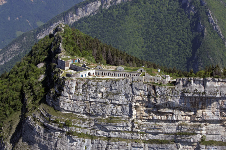
A loop to admire one of the most beautiful points of view on Grenoble and discover the fort, perched at 1338m, built between
1873 and 1879 to protect the city from aggression since the
valley as from the mountain - yet it has never been used!
Route labeled FFRandonnée

The characteristics of the route.

Le Sappey-en-Chartreuse (38)
- Distance 8.2 km
- Elevation gain 560 m
- Elevation lost 560 m
- Min. elevation 984 m
- Max. elevation. 1355 m
- Duration (depending on pace) 2h30
- Marking Yes
Admission fee : Free of charge.Opening : From 01/05 to 30/11 daily.Step by step description : (1) From the parking lot, you can reach the Croix du Rocher, which marks the start of the GR9 towards the Fort du Saint-Eynard. The marked trail (red and white) crosses a small torrent and then reaches the acrobatic park, where a path joins the downhill ski slopes. The ascent to the ridge is via these pistes. The GR leaves the piste and branches off to the left just before climbing the ridge. (2) End of difficulties: the rest of the route is relatively flat and straight.
Past the Pas Guiguet, you reach the old batteries and then the fort. For the best view of Grenoble, continue on the GR around the ditch and up to a platform offering an unobstructed panorama (3). (4) To make a loop towards Le Sappey, return to the end of the old batteries and mark the start of the yellow-marked path, which descends through the woods, crossing the road several times and leading back to the hamlet of Pillonières. From here, the path leads to La Faurie and then back to the Parc Acrobatique.
Things to see and do nearby:
- Petits Jardiniers (10 km from the start): medicinal plant cultivation.
- Musée Arcabas en Chartreuse (13 km from the start): St Hugues church.
- Badiane Créations (14 km from the start): clothing creations.
- Musée de la Grande Chartreuse (15 km from the start): audio-guided tour.
Information / safety :
- It's a good idea to adopt a few rules and follow a few tips to make the most of your walks and hikes in complete safety! Before setting off, follow our recommendations and advice at chartreuse-tourisme.com/conseils-rando-trail (or on request at tourist offices).
- A mountain leader is a specialist in mountain fauna and flora, off-trail hiking away from the crowds, local history, alpine and farming traditions, etc. in complete safety! Just ask! Detailed list on chartreuse-tourisme.com/accomp (or at tourist offices).
- You hike under your own responsibility. Chartreuse Tourisme and the tourist offices cannot be held responsible for the itineraries proposed.
Useful numbers :
- Meteo (please consult before setting off): 3250 or www.meteo.fr
- Mountain rescue: 112
Area : Grenoble-Alpes Métropole
Report a problem
Website Pdf file Features of the application :
- Location and orientation on detailed maps thanks to the GPS of your smartphone
- Description of routes and points of interest on the route
- Photo gallery by route
- Detailed elevation profile
- Route tracking alert to warn you if you stray from the route
- Send predefined messages by SMS to your contacts
- Emergency module: trigger a call or send an emergency SMS in case of problem
- Agenda: access to events organized in the department
- News: find in the application the latest news on the web portal
- Adding achievements
- Add reports in case of problems encountered on the routes
- Share on social networks
Add your time and share your feelings
Services nearby

Sappey-en-Chartreuse Tourist Information Center
Le Sappey-en-Chartreuse

Col de Porte
Sarcenas

Musée Hébert
La Tronche

Espace naturel sensible du col du Coq
Plateau des Petites Roches
Espace naturel sensible du Bois de la Batie
Saint-Ismier


Follow us on
the digital trails
the digital trails


![]()
The Isère Outdoor application was created
by the Département de l'Isère
Infos & contact
Conseil départemental de l'Isère
7 rue Fantin Latour
CS 41096
38 022 Grenoble cedex 1
Tel. 04 76 00 38 38
 Isère Outdoor - Parcours - Crêtes du St Eynard
Hello, world! This is a toast message.
Isère Outdoor - Parcours - Crêtes du St Eynard
Hello, world! This is a toast message.
Isère Outdoor - Parcours - Crêtes du St Eynard
Hello, world! This is a toast message.


OK
Annuler