VTTAE - Etrip sous la Dent de l’Ours
Add to my favorites

Caution! Zone of vigilance near the route
Aigle royal - du 01/01/2026 au 31/08/2026 In progress
A round trip to initiate you into e-Bike. This itinerary is recommended to people used to mountain biking.
The characteristics of the route.
Saint-Pierre-d'Entremont (38)
- Distance 13.7 km
- Elevation gain 480 m
- Elevation lost 480 m
- Min. elevation 644 m
- Max. elevation. 998 m
- Duration (depending on pace) 3h
- Marking Yes
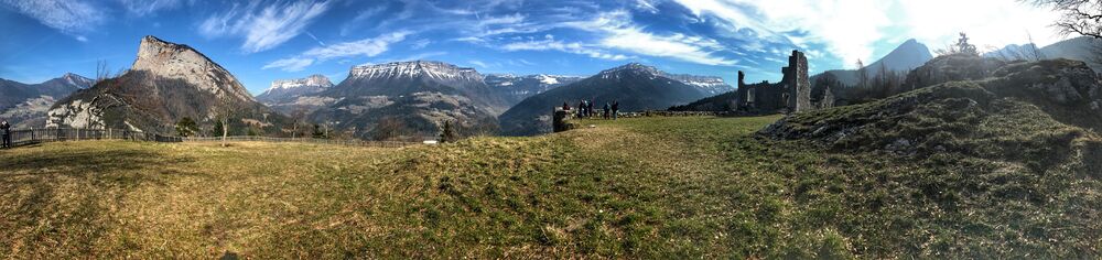
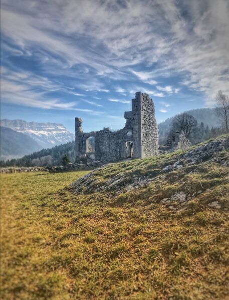
(1) From the tourist office, follow St-Pierre-de-Chartreuse. At the village exit, take the road D102b which goes right. (2) At the first bend, take left the ‘Chemin du Nan’ towards ‘Le Villard’. At the fork, take the road on the right to meet the hamlet of ‘Préversin’. There, take left. Do not miss, 300 meters away, after the last house of the hamlet, the path going up on the right to the hamlet ‘Le Villard’. Go up for about 1 km on this path and keep left at the junction. (3) The path opens up on the hamlet ‘Le Villard’, just above the goat farm of Labérou. Sale of goat cheese in the farm! Going straight, take the path to ‘Les Reys’. (4) At the yellow sign ‘Les Reys – 940 m’, take left the path which goes down in a valley and that crosses a field. The path leads to the village of ‘St Philibert’. Go straight on and take the path starting in the first bend. (5) 1 km further, turn 180° on the right to ‘Les Reys’ and ‘St-Pierre-d’Entremont’. Follow the path, leading to ‘Les Arragons’, on the B-road D102b. (6) Cross the hamlets of ‘Les Arragons’ and ‘Les Reys’. From this road the view is amazing. Stay on the D102b to ‘Le Villard’. After the vacation centre and some bends, take the ‘Chemins des Fontanettes’, a paved way going up steep the left. (7) At the top of the way up, take left again. After a bend on the right and a way up for about 50 m, turn right on a small path next to a private road. This path (chemin des Champas) after one pleasant kilometer, meets the road of Touvière. Take this road to the hamlet ‘Le Château’. (8) To reach the ruins of the Castel of Montbel, turn right on a small path after the oven and the washing place. To go back to your starting point, take the road again and leave on your right the path you took to come. Pass the hamlet ‘Paquet’, take left the path of the ‘Circuit du Château Randocroquis’, which leads to the B-road D102b through a long and steep descent. Turn left and follow the road to go back to the centre of the village.Equipments : Free car park, Car park, Public WC, Admission fee : Free access.Opening : From 01/05 to 31/10.
Subject to favorable weather.
Area : Cœur de Chartreuse
Report a problem
Website Pdf file Features of the application :
- Location and orientation on detailed maps thanks to the GPS of your smartphone
- Description of routes and points of interest on the route
- Photo gallery by route
- Detailed elevation profile
- Route tracking alert to warn you if you stray from the route
- Send predefined messages by SMS to your contacts
- Emergency module: trigger a call or send an emergency SMS in case of problem
- Agenda: access to events organized in the department
- News: find in the application the latest news on the web portal
- Adding achievements
- Add reports in case of problems encountered on the routes
- Share on social networks
Add your time and share your feelings
Services nearby

Coeur de Chartreuse Tourist Information center at Saint Pierre d'Entremont
Saint-Pierre-d'Entremont
Coeur de Chartreuse Tourist Information center at Saint Pierre de Chartreuse
Saint-Pierre-de-Chartreuse

Museum of la Grande Chartreuse
Saint-Pierre-de-Chartreuse
Coeur de Chartreuse Tourist Information center at Saint Laurent du Pont
Saint-Laurent-du-Pont
Museum of Contemporary Sacred Art
Saint-Pierre-de-Chartreuse


Information updated on 2024-07-12 by Isère Attractivité


Follow us on
the digital trails
the digital trails


![]()
The Isère Outdoor application was created
by the Département de l'Isère
Infos & contact
Conseil départemental de l'Isère
7 rue Fantin Latour
CS 41096
38 022 Grenoble cedex 1
Tel. 04 76 00 38 38
 Isère Outdoor - Parcours - VTTAE - Etrip sous la Dent de l’Ours
Hello, world! This is a toast message.
Isère Outdoor - Parcours - VTTAE - Etrip sous la Dent de l’Ours
Hello, world! This is a toast message.
Isère Outdoor - Parcours - VTTAE - Etrip sous la Dent de l’Ours
Hello, world! This is a toast message.


OK
Annuler