Loop of Chamechaude
Add to my favorites

Caution! Zone of vigilance near the route
Bachasson - du 26/07/2026 au 15/09/2026 Upcoming
Habert Chamechaude - du 25/06/2026 au 26/07/2026 Upcoming
Piste de ski col de Porte - du 15/09/2026 au 28/09/2026 Upcoming
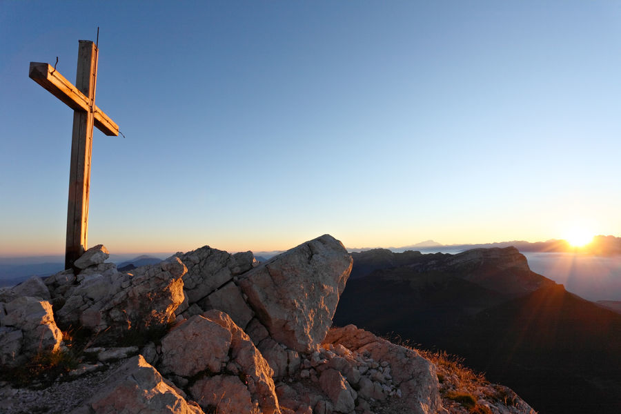
Suitable for experienced walkers only, this loop up to the peak of the Chartreuse mountains is an alternative to the simple path to and from the Col de Porte.
The characteristics of the route.

Le Sappey-en-Chartreuse (38)
- Distance 15.3 km
- Elevation gain 1170 m
- Elevation lost 1170 m
- Min. elevation 1000 m
- Max. elevation. 2074 m
- Duration (depending on pace) 5h
- Marking Yes
From Le Sappey Eglise, go to the hamlet of La Charmette (1), follow the signs and yellow markings to Le Habert de Chamechaude. At Jailleres, continue straight on. At Le Bruchet, continue towards Le Habert de Chamechaude. At Le Habert, turn left (2). At the Cabane de Bachasson (3) (the only watering place on the route), follow "Chamechaude". From here, the route to the summit (4) is a round trip. Back at the Bachasson hut, turn right and follow "Col de Porte". At the pass (5), take the yellow, red and white signposted path (GR 9) on the left towards "Le Sappey Église".
When the forest track joins the road, follow it for 30 m and turn right down the Chemin des Chartreux (yellow markings). At the last crossroads, follow "Le Sappey l'Eglise" to reach the start (6).
Things to see/do near the route:
- Musée Arcabas en Chartreuse (13 km from the start): St Hugues church.
- Badiane Créations (14 km from start): clothing creations.
- Musée de la Grande Chartreuse (15 km from the start): audio-guided tour.
For more information and other tour ideas, visit chartreuse-tourisme.com/rsf
Information / safety :
- to make the most of your walks and hikes in complete safety, it's a good idea to adopt a few rules and follow a few tips! Before setting off, follow our recommendations and advice on chartreuse-tourisme.com/conseils-rando-trail (or on request from tourist offices).
- A mountain leader is a specialist in mountain fauna and flora, off-trail hiking away from the crowds, local history, alpine and farming traditions, etc. in complete safety! Just ask! Detailed list on chartreuse-tourisme.com/accomp (or at tourist offices).
- You hike under your own responsibility. Chartreuse Tourisme and the tourist offices cannot be held responsible for the itineraries proposed.
Useful numbers :
- Meteo (please consult before setting off): 3250 or www.meteo.fr
- Mountain rescue: 112Equipments : Public WC, Car park, Admission fee : Free of charge.Opening : From 01/05 to 30/11 daily.Step by step description : At the hamlet of La Charmette (1), follow the road signs and the red and white GR9 signs for Le Habert de Chamechaude. At Jailleres, continue straight on. At Le Bruchet, follow the GR9 towards Le Habert de Chamechaude. At Le Habert, turn left (2). At the Cabane de Bachasson (3) (the only watering place on the route), follow "Chamechaude". From here the route to the summit (4) is a round trip. Back at the cabane de Bachasson, turn right and follow "col de Porte". At the pass (5), take the yellow and red yellow and red path (GR de Pays) towards "Le Sappey Église". When the forest track joins the road, follow it for 30 m and turn right down the Chemin des Chartreux (yellow markings). At the last crossroads, follow "Le Sappey l'Eglise" to reach the start (6).
Area : Grenoble-Alpes Métropole
Report a problem
Website Pdf file Features of the application :
- Location and orientation on detailed maps thanks to the GPS of your smartphone
- Description of routes and points of interest on the route
- Photo gallery by route
- Detailed elevation profile
- Route tracking alert to warn you if you stray from the route
- Send predefined messages by SMS to your contacts
- Emergency module: trigger a call or send an emergency SMS in case of problem
- Agenda: access to events organized in the department
- News: find in the application the latest news on the web portal
- Adding achievements
- Add reports in case of problems encountered on the routes
- Share on social networks
Add your time and share your feelings
Services nearby

Sappey-en-Chartreuse Tourist Information Center
Le Sappey-en-Chartreuse

Col de Porte
Sarcenas

Musée Hébert
La Tronche

Espace naturel sensible du col du Coq
Plateau des Petites Roches
Espace naturel sensible du Bois de la Batie
Saint-Ismier


Follow us on
the digital trails
the digital trails


![]()
The Isère Outdoor application was created
by the Département de l'Isère
Infos & contact
Conseil départemental de l'Isère
7 rue Fantin Latour
CS 41096
38 022 Grenoble cedex 1
Tel. 04 76 00 38 38
 Isère Outdoor - Parcours - Loop of Chamechaude
Hello, world! This is a toast message.
Isère Outdoor - Parcours - Loop of Chamechaude
Hello, world! This is a toast message.
Isère Outdoor - Parcours - Loop of Chamechaude
Hello, world! This is a toast message.


OK
Annuler