Chamechaude - Summit
Add to my favorites

Caution! Zone of vigilance near the route
Bachasson - du 26/07/2026 au 15/09/2026 Upcoming
Habert Chamechaude - du 25/06/2026 au 26/07/2026 Upcoming
Piste de ski col de Porte - du 15/09/2026 au 28/09/2026 Upcoming
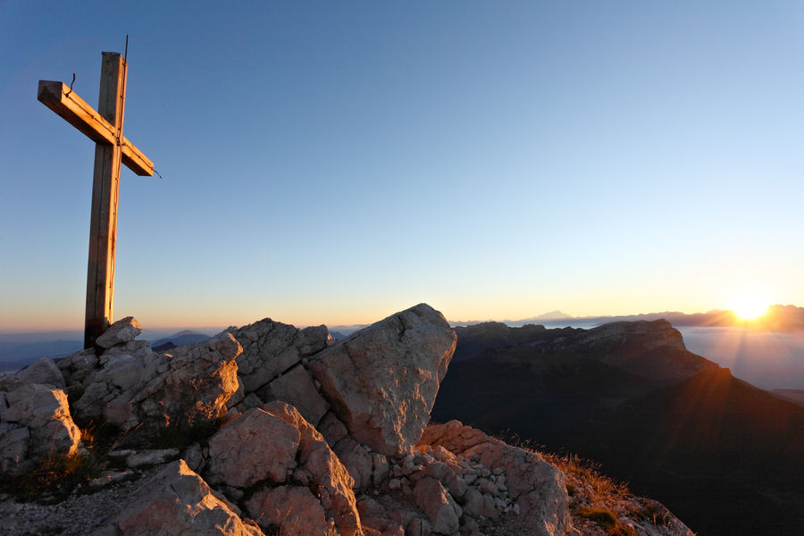
Chamechaude is the highest peak of the Chartreuse massif (2082m). Privileged place for all those who like the difference in height. It offers an exceptional panorama.
The characteristics of the route.

Sarcenas (38)
- Distance 8.1 km
- Elevation gain 750 m
- Elevation lost 750 m
- Min. elevation 1322 m
- Max. elevation. 2074 m
- Duration (depending on pace) 5h
- Marking Yes
Equipments : Car park, Admission fee : Free of charge.Opening : From 01/05 to 30/11.
Subject to favorable weather.Step by step description : From the Col de Porte parking lot, head towards the cross-country fireplace and follow the signs for "Cabane de Bachasson". The path initially skirts the meadow, then quickly forks into the forest to reach the hut.
From here, continue left towards La Folatière to the summit. On both the ascent and descent, keep to the S-shaped path to minimize erosion. The descent follows the same route.
For the return journey, and to avoid a return trip along the same route, extend the hike back to the Bachasson hut and continue towards Pré Boiteux and on to Habert de Chamechaude.
Descend towards Le Sappey en Chartreuse. At Montjalat, join Le Churut then Le Réservoir. Follow the GR9 at Appanon and turn right up to Col de Porte.
Things to see/do near the route:
- Petits Jardiniers (5km from the start): medicinal plant cultivation.
- Musée d'Art Sacré Contemporain (8km from the start): St Hugues church.
- Grande Chartreuse Museum (10km from start): audio-guided tour.
- Fort du St-Eynard (10km from the start): tour of the fort and exceptional panorama.
All the info and other ideas for visits on chartreuse-tourisme.com
Information / safety :
- to make the most of your walks and hikes in complete safety, it's a good idea to adopt a few rules and follow a few tips! Before setting off, follow our recommendations and advice on chartreuse-tourisme.com/conseils-rando-trail (or on request from tourist offices).
- A mountain leader is a specialist in mountain fauna and flora, off-trail hiking away from the crowds, local history, alpine and farming traditions, etc. in complete safety! Just ask! Detailed list on chartreuse-tourisme.com (or at tourist offices).
- You hike under your own responsibility. Chartreuse Tourisme and the tourist offices cannot be held responsible for the itineraries proposed.
Useful numbers :
- Weather (please consult
Area : Grenoble-Alpes Métropole
Report a problem
Pdf file Features of the application :
- Location and orientation on detailed maps thanks to the GPS of your smartphone
- Description of routes and points of interest on the route
- Photo gallery by route
- Detailed elevation profile
- Route tracking alert to warn you if you stray from the route
- Send predefined messages by SMS to your contacts
- Emergency module: trigger a call or send an emergency SMS in case of problem
- Agenda: access to events organized in the department
- News: find in the application the latest news on the web portal
- Adding achievements
- Add reports in case of problems encountered on the routes
- Share on social networks
Add your time and share your feelings
Services nearby

Col de Porte
Sarcenas

Sappey-en-Chartreuse Tourist Information Center
Le Sappey-en-Chartreuse
Location de matériel au foyer de ski de fond
Saint-Pierre-de-Chartreuse

Museum of Contemporary Sacred Art
Saint-Pierre-de-Chartreuse

Espace naturel sensible du col du Coq
Plateau des Petites Roches


Information updated on 2025-05-06 by Chartreuse Tourisme


Follow us on
the digital trails
the digital trails


![]()
The Isère Outdoor application was created
by the Département de l'Isère
Infos & contact
Conseil départemental de l'Isère
7 rue Fantin Latour
CS 41096
38 022 Grenoble cedex 1
Tel. 04 76 00 38 38
 Isère Outdoor - Parcours - Chamechaude - Summit
Hello, world! This is a toast message.
Isère Outdoor - Parcours - Chamechaude - Summit
Hello, world! This is a toast message.
Isère Outdoor - Parcours - Chamechaude - Summit
Hello, world! This is a toast message.


OK
Annuler