


Chamrousse Tourist Office acquired the "Quality Tourism" label again in 2017 and offers a warm and personalised welcome at its two information desks.We have two information points in Chamrousse 1650 and Chamrousse 1750, a booking centre "Chamrousse Reservation", a souvenir shop and a free wifi area at your disposal.
Recoin information point 1650 in the Tourism house is open throughout the year and Roche-Béranger information point 1750 in the shopping gallery is open only during the high season (winter and summer).Period of opening : All year round.
Closed exceptionally on Feast of the Ascension, Whit Monday, May 1st, May 8th, November 1st and November 11th.
? Works with closure of the physical reception from May,18th to June, 1st 2022, but still telephone reception.


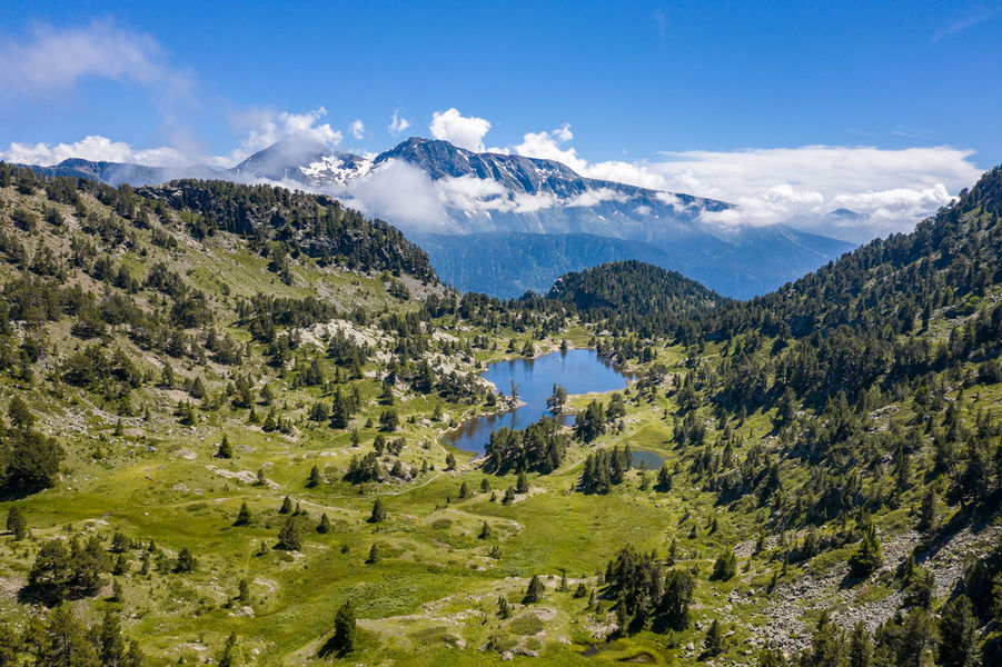
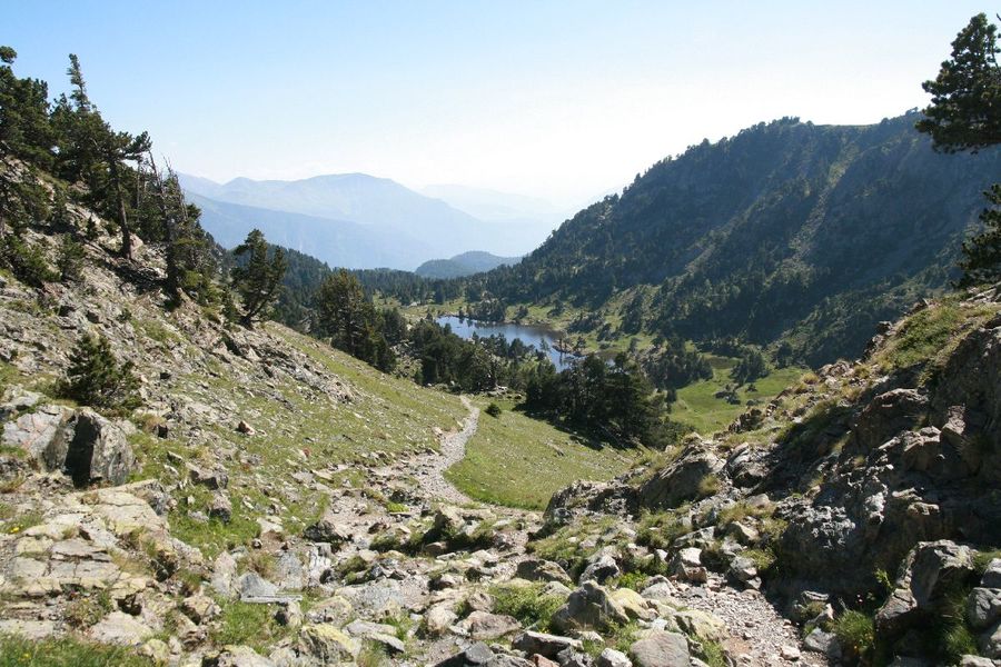
At 2100 meters, the refuge of La Pra, close to the many clear lakes of the Massif Belledonne, will delight anglers, hikers and families. La Pra is also a wonderful pasture where you can encounter marmots, wild sheep and ibex.Getting there :
1/ at the car park of Pré Raymond, take the forest road then a trail to the left (southeast). Some laces lead you to an almost horizontal path that allows you to get out of the forest. Cross the stream before reaching the dam and the Lac du Crozet. Follow the path along the lake and walk up the valley of Mercier to the Col de la Pra. At the mountain pass, turn right (south) and get to the refuge located 5 minutes from the Col de la Pra.
2/ In Chamrousse, from the car park at the foot of the Grande Aiguille, follow the GR of Pays then pass between the lakes (path GR 738). Climb back up slightly before descending into the valley of l'Echaillon. Leave on your left the path to the waterfalls of l'Oursière, then on your right the path to the lake David. Climb back to Lake Leama and reach lakes Longet and Claret. Climb to the ledge where you will find the refuge.
3/ At the Recoin de Chamrousse, take the path GR 738 to reach the lakes Robert. Then follow the same itinerary as the one by the Croix de Chamrousse.
High gain : 740m/400m
Walking time : 3h30/4h
Ease of access :
IGN map : Top 25 3335OTPeriod of opening : From 08/06 to 18/09, daily.
From 19/09 to 07/06, daily.
Dates to be confirmed. Subject to snow conditions.Prices : From 08/06 to 18/09/2022
Night: 12.50 to 25 €
Child rate per night : 13.75 to 20 €
CAF member rate per night: 6.25 to 12.50 €
Bed and breakfast: 19 to 29.50 €
Half board (pp): 42 to 54.50 €
Half-board (child) : 19 to 46 €
Group rate per night: from 20 €
Shower: 3 €
Picnic to take away: 11 €
Tourist taxes: 0.50 €.
From 19/09/2022 to 07/06/2023
Night: 8 €.
Free entry for children < 3 years.
Child entry valid for 4 - 8 years.
Group rate available for > 9 people.
Tax not included.
Access : Access by car : 1/ from Freydière (Revel town, at 2h30 walk) 2/ from Chamrousse (at 3h30 walk).
Access by public transport : Transisère 6010 from Grenoble to Recoin (Chamrousse town).
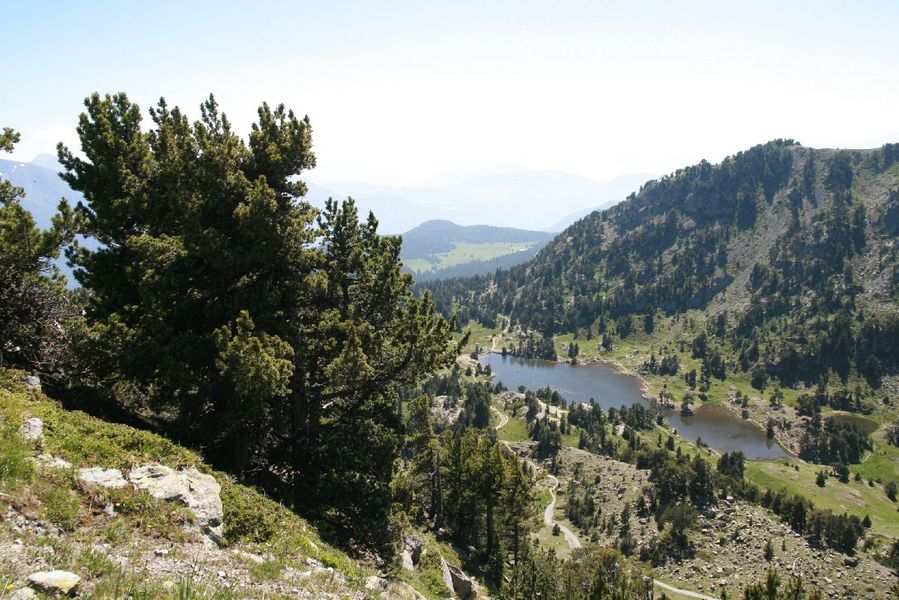
The site is composed of the catchment area of Lake Achard, as well as the valley and the vast peaty plateau of Arselle, which are crossed by the Salinière stream. This site has been included in the Natura 2000 (Europe) and ENS* (Department) networks.Because of the peat bog that makes up the plateau, and its landscape, botanical and faunistic interest, the Arselle plateau is a natural area protected by an arrêté préfectoral de protection de biotope since 2019. The aim of this decree is to preserve the site and the plant and animal species present.
This peat bog is of a particular type, as it forms on acidic soils. Few plant species can colonize this environment (e.g. sphagnum moss, cattail and common butterwort). Droséra and Grassette are carnivorous species. These flowers feed on insects that provide them with the nitrogen they can't find in this poor soil. They capture the insects and digest them using enzymes contained in the viscous droplets they secrete.
Similarly, the forest, wetland and rocky habitats in the Lac Achard watershed and in the Vallon de la Salinière are home to a wealth of heritage flora and fauna, which led to an extension of the ENS perimeter, in order to preserve them in the face of increasing visitor numbers.
The site is home to many protected species: the Arctic cordillera (dragonfly), Vandeli's androsacea (flower), Frog orchid, Alpine newt (amphibian), Bearded vulture (bird), Alpine ibex, Schreibers miniopter (bat), and more.
Take to the trails to discover these rare and sensitive environments, accompanied by local guides: Bureau des Guides de Chamrousse and Belledonne en marche.
? Please note: burning, camping, fishing and swimming are strictly forbidden (under penalty of fine). Bivouacs are permitted on Lac Achard from sunset to sunrise (except from early May to late October + Infernet area) and strictly forbidden on the Arselle plateau. Please stay on the paths to preserve the fragile environment (the Arselle peat bog is classified as an APPB - Arrêtés Préfectoraux de Protection Biotope - and it is forbidden to go onto the plateau off the path).

