GR®738 - Mountain pasture loop: Robert lakes
Add to my favorites

Departure/Arrival : Recoin (1650m) - city centre.
- "Recoin" -> Balme col -> Robert lakes : 2h30
- Robert lakes -> Pourettes lake -> "Recoin" : 2h.
The characteristics of the route.

Chamrousse (38)
- Distance 7.5 km
- Elevation gain 500 m
- Elevation lost 500 m
- Min. elevation 1672 m
- Max. elevation. 2044 m
- Duration (depending on pace) 4h30
- Marking Yes
This new GR® in Belledonne, approved in June 2018, is 130 km long and has no less than 10,000 metres of vertical drop.
For the sportiest, the High Crossing in 11 stages is a complete crossing of the mountain chain from the bottom of the valley to more than 2,000 m of height, an immersion in a wild and surprising massif, between pastures and lakes.
But there is one for all practices, with itinerant routes of 2 to 4 days and full-day loops, like the discovery of the pastures in Chamrousse, 1st loop of this crossing of Belledonne.
The start of this loop is in the heart of Chamrousse - Recoin, in an almost urban environment. Very quickly, we enter the resort via the GR®738 towards the Balme pass.
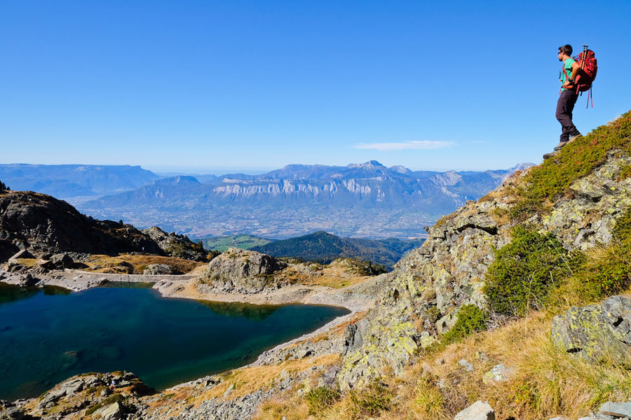
The road then continues to the edge of the Robert Lakes. The atmosphere becomes much more mineral and the black rock contrasts with the emerald green of the water.
After walking around the two largest lakes, you escape through the northern breach and wind between the blocks before reaching the edge of the Pourettes Lake. This part of the route has several small lakes like this one.
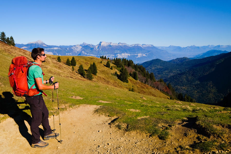
After passing the Pourettes Lake, follow the path towards the starting point. Just before going down to Le Recoin, a superb panorama emerges on the Vercors. On the far, the Mont Aiguille stands alone.
For more informations, visit the website of the "Haute traversée de Belledonne"!
Attention: the shepherd of Chamrousse has dogs with his herd (but no patous), for a good cohabitation between mountain people and the work of the shepherd, thank you for respecting some instructions. Do not cross the herd, do not try to pet or feed the dogs or the herd, do not make sudden gestures or throw things that could frighten the dog, do not start running and avoid taking photos from too close...
? Little extra: "Hiking star" a medal for children in summer too!
Showing us a picture taken during their hike, courageous little walkers will be awarded a diploma with their name + gold star "Robert lakes" on sale (2.50€ at the Tourist Offices) to wear proudly on the backpack.Equipments : Parking nearby, Public WC, Good plans : Panoramic view of the TailleferAdmission fee : Free access.Opening : From 15/06 to 15/10. Subject to snow conditions.
For the sportiest, the High Crossing in 11 stages is a complete crossing of the mountain chain from the bottom of the valley to more than 2,000 m of height, an immersion in a wild and surprising massif, between pastures and lakes.
But there is one for all practices, with itinerant routes of 2 to 4 days and full-day loops, like the discovery of the pastures in Chamrousse, 1st loop of this crossing of Belledonne.
The start of this loop is in the heart of Chamrousse - Recoin, in an almost urban environment. Very quickly, we enter the resort via the GR®738 towards the Balme pass.
The road then continues to the edge of the Robert Lakes. The atmosphere becomes much more mineral and the black rock contrasts with the emerald green of the water.
After walking around the two largest lakes, you escape through the northern breach and wind between the blocks before reaching the edge of the Pourettes Lake. This part of the route has several small lakes like this one.
After passing the Pourettes Lake, follow the path towards the starting point. Just before going down to Le Recoin, a superb panorama emerges on the Vercors. On the far, the Mont Aiguille stands alone.
For more informations, visit the website of the "Haute traversée de Belledonne"!
Attention: the shepherd of Chamrousse has dogs with his herd (but no patous), for a good cohabitation between mountain people and the work of the shepherd, thank you for respecting some instructions. Do not cross the herd, do not try to pet or feed the dogs or the herd, do not make sudden gestures or throw things that could frighten the dog, do not start running and avoid taking photos from too close...
? Little extra: "Hiking star" a medal for children in summer too!
Showing us a picture taken during their hike, courageous little walkers will be awarded a diploma with their name + gold star "Robert lakes" on sale (2.50€ at the Tourist Offices) to wear proudly on the backpack.Equipments : Parking nearby, Public WC, Good plans : Panoramic view of the TailleferAdmission fee : Free access.Opening : From 15/06 to 15/10. Subject to snow conditions.
Area : Grésivaudan
Report a problem Add a comment
Website Pdf file Alpine pasture GR738 hiking loop track Features of the application :
- Location and orientation on detailed maps thanks to the GPS of your smartphone
- Description of routes and points of interest on the route
- Photo gallery by route
- Detailed elevation profile
- Route tracking alert to warn you if you stray from the route
- Send predefined messages by SMS to your contacts
- Emergency module: trigger a call or send an emergency SMS in case of problem
- Agenda: access to events organized in the department
- News: find in the application the latest news on the web portal
- Adding achievements
- Add reports in case of problems encountered on the routes
- Share on social networks
Add your time and share your feelings
Services nearby

Chamrousse Tourist Office
Chamrousse

Arselle Peatbog (Preserved Natural Area)
Chamrousse

Romanche Museum
Livet-et-Gavet
Office Thermal et Touristique d'Uriage-les-Bains
Saint-Martin-d'Uriage

Refuge de la Pra
Revel


Information updated on 2023-05-26 by Office du Tourisme de Chamrousse


Follow us on
the digital trails
the digital trails


![]()
The Isère Outdoor application was created
by the Département de l'Isère
Infos & contact
Conseil départemental de l'Isère
7 rue Fantin Latour
CS 41096
38 022 Grenoble cedex 1
Tel. 04 76 00 38 38


OK
Annuler