The Castle circuit - drawing circuit
Add to my favorites

Caution! Zone of vigilance near the route
Aigle royal - du 01/01/2026 au 31/08/2026 In progress
A loop trail to discover the Montbel Castle and its stunning panorama. As a Randocroquis®, it also provides an introduction to sketching techniques. Leaflets available upon request at the tourist information center.
The characteristics of the route.

Saint-Pierre-d'Entremont (38)
- Distance 6.3 km
- Elevation gain 360 m
- Elevation lost 360 m
- Min. elevation 579 m
- Max. elevation. 927 m
- Duration (depending on pace) 2h30
- Marking Yes
After passing through the village and crossing the bridges over the Guiers and Cozon rivers, you'll embark on the winding "Buis" road, which offers an impressive view of the Frou gorges road and its cliffs. Departing from the road, you'll venture onto the signposted path that traverses the river, where you can savor the refreshing, pastoral scenery before continuing your journey.
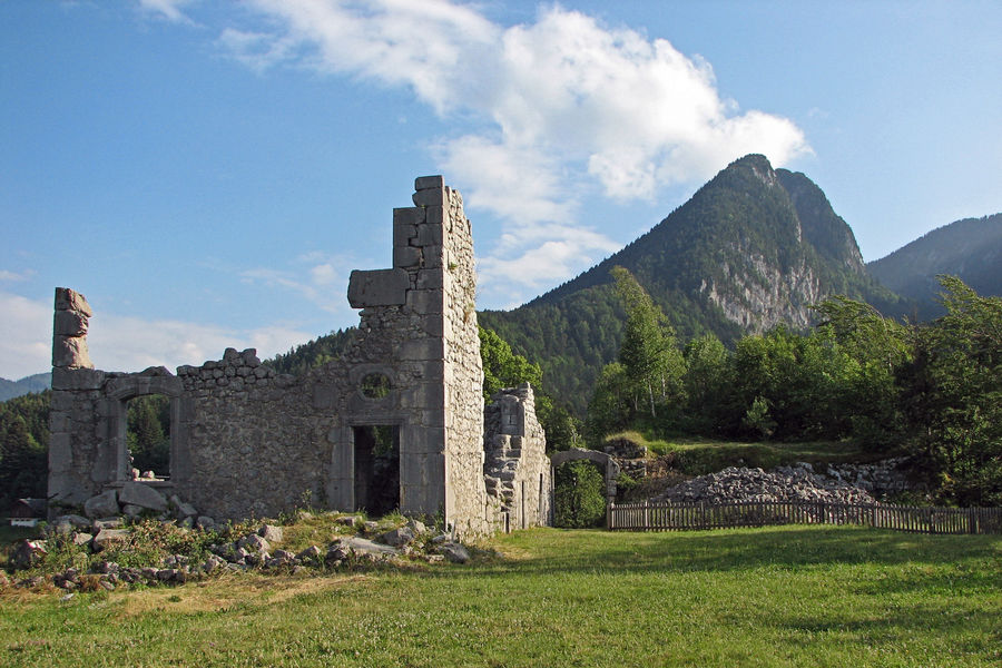
A beautiful forest ascent awaits you, promising a rewarding effort as you ascend towards the hamlet of Le Château. Here, you'll encounter the ruins of Château de Montbel on your left, once a stronghold of the Lords of Entremont, constructed in 1306 and left in ruins since the French Revolution. A magnificent stone orientation table provides the names of all the surrounding mountains, allowing you to admire the breathtaking panorama. Picnics and siestas are encouraged in the meadow surrounding the château.
Upon returning to the hamlet, you'll pass by the historic oven and pond, tracing the course of history alongside the bucket wheel of an old beating saw. As you depart from the hamlet, a descending path will lead you back to the road, guiding you towards the village.Marking : Departure signs are installed in the villages near the car parks and public areas. To follow your itinerary, poles are positioned at the intersections and identifiable by a sign displaying the name of the trail and its altitude. Between two poles, you will find marked signs painted along the way, indicating whether to continue on the path or not. Also, pay attention to small signs to guide you. We recommend having the "Promenades et randonnées en Chartreuse" map with you.Admission fee : Free access.Opening : From 01/05 to 30/11. Subject to favorable weather.Step by step description : The Randocroquis booklet is available from the Saint-Pierre-d'Entremont Tourist Office. 1/ From the Tourist Office, follow the Corbel signposted route (yellow sign at the corner of the Tourist Office). Continue along the road, crossing the point on the Guiers vif, then straight on to the St Alexis church in St Pierre d'Entremont Savoie. 2/ Cross the bridge opposite the church and turn left along the road (signposted Le Château). Continue along the road, passing the school on your right, a quarry further on your left, then at the last houses, at the crow's feet, take the road on the left below which descends to the Guiers vif river. 3/ At the Les Buis sign, leave the road and take the yellow signposted path on the left. At the footbridge, the first Randocroquis® table offers a drawing workshop. Continue up the path until you reach the main road. Cross the road (with care) and continue straight ahead. The path climbs through the forest to the hamlet of Le Château (this climb is not passable in snowy weather). 4/ At the hamlet, take the left-hand path leading to the Château de Montbel ruins. The site offers exceptional panoramic views over the Entremonts valley, Randocroquis® tables and a relief orientation table. Once back in the hamlet, take the road down past the oven and basin. Then follow the bucket wheel of an old beating saw. The signposting continues along the road to the hamlet of Terray. 5/ After the last houses, take the path on the left, which winds through forest and meadows. Follow the road down to the village.
Area : Cœur de Chartreuse
Report a problem
Pdf file Features of the application :
- Location and orientation on detailed maps thanks to the GPS of your smartphone
- Description of routes and points of interest on the route
- Photo gallery by route
- Detailed elevation profile
- Route tracking alert to warn you if you stray from the route
- Send predefined messages by SMS to your contacts
- Emergency module: trigger a call or send an emergency SMS in case of problem
- Agenda: access to events organized in the department
- News: find in the application the latest news on the web portal
- Adding achievements
- Add reports in case of problems encountered on the routes
- Share on social networks
Add your time and share your feelings
Services nearby

Coeur de Chartreuse Tourist Information center at Saint Pierre d'Entremont
Saint-Pierre-d'Entremont
Coeur de Chartreuse Tourist Information center at Saint Pierre de Chartreuse
Saint-Pierre-de-Chartreuse

Museum of la Grande Chartreuse
Saint-Pierre-de-Chartreuse
Coeur de Chartreuse Tourist Information center at Saint Laurent du Pont
Saint-Laurent-du-Pont
Museum of Contemporary Sacred Art
Saint-Pierre-de-Chartreuse


Information updated on 2024-10-22 by Chartreuse Tourisme


Follow us on
the digital trails
the digital trails


![]()
The Isère Outdoor application was created
by the Département de l'Isère
Infos & contact
Conseil départemental de l'Isère
7 rue Fantin Latour
CS 41096
38 022 Grenoble cedex 1
Tel. 04 76 00 38 38
 Isère Outdoor - Parcours - The Castle circuit - drawing circuit
Hello, world! This is a toast message.
Isère Outdoor - Parcours - The Castle circuit - drawing circuit
Hello, world! This is a toast message.
Isère Outdoor - Parcours - The Castle circuit - drawing circuit
Hello, world! This is a toast message.


OK
Annuler