L'Ecoutoux
Add to my favorites

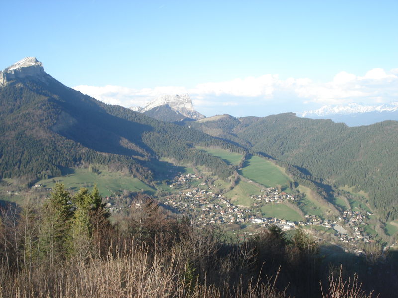
Round trip for good walkers, in the forest with some steep slopes but the game is worth the candle: at the top, the panorama is breathtaking.
The characteristics of the route.

Le Sappey-en-Chartreuse (38)
- Distance 8 km
- Elevation gain 430 m
- Elevation lost 430 m
- Min. elevation 1000 m
- Max. elevation. 1390 m
- Duration (depending on pace) 2h30
- Marking Yes
Admission fee : Free of charge.Opening : From 01/05 to 30/11.Step by step description : (1) Turn left over the square, following signs for the hamlet of BENS ("écurie du Sappey" indicated). (2) Continue along the Sagnes marsh, classified as a sensitive natural area. Once past the houses, the path crosses the embankment on the left, after the pond. It joins two houses, then continues to climb past the second. You then come to the hamlet
of Bens, where you'll find the riding school. Go straight on to the Col de Bens, then take the left-hand "Écoutoux" path (3). Climb to the summit and enjoy the 360° view, with Grenoble on one side and the Chartreuse massif on the other. Return by the same route.
Things to see and do nearby:
- Petits Jardiniers (10 km from the start): medicinal plant cultivation.
- Musée Arcabas en Chartreuse (13 km from the start): St Hugues church.
- Badiane Créations (14 km from the start): clothing creations.
- Musée de la Grande Chartreuse (15 km from the start): audio-guided tour.
For more information and other tour ideas, visit chartreuse-tourisme.com/rsf
Information / safety :
- to make the most of your walks and hikes in complete safety, it's a good idea to adopt a few rules and follow a few tips! Before setting off, follow our recommendations and advice on chartreuse-tourisme.com/conseils-rando-trail (or on request from tourist offices).
- A mountain leader is a specialist in mountain fauna and flora, off-trail hiking away from the crowds, local history, alpine and farming traditions, etc. in complete safety! Just ask! Detailed list on chartreuse-tourisme.com/accomp (or at tourist offices).
- You hike under your own responsibility. Chartreuse Tourisme and the tourist offices cannot be held responsible for the itineraries proposed.
Useful numbers :
- Meteo (please consult before setting off): 3250 or www.meteo.fr
- Mountain rescue: 112
Area : Grenoble-Alpes Métropole
Report a problem
Website Pdf file Features of the application :
- Location and orientation on detailed maps thanks to the GPS of your smartphone
- Description of routes and points of interest on the route
- Photo gallery by route
- Detailed elevation profile
- Route tracking alert to warn you if you stray from the route
- Send predefined messages by SMS to your contacts
- Emergency module: trigger a call or send an emergency SMS in case of problem
- Agenda: access to events organized in the department
- News: find in the application the latest news on the web portal
- Adding achievements
- Add reports in case of problems encountered on the routes
- Share on social networks
Add your time and share your feelings
Services nearby

Sappey-en-Chartreuse Tourist Information Center
Le Sappey-en-Chartreuse

Col de Porte
Sarcenas

Musée Hébert
La Tronche

Espace naturel sensible du col du Coq
Plateau des Petites Roches
Espace naturel sensible du Bois de la Batie
Saint-Ismier


Follow us on
the digital trails
the digital trails


![]()
The Isère Outdoor application was created
by the Département de l'Isère
Infos & contact
Conseil départemental de l'Isère
7 rue Fantin Latour
CS 41096
38 022 Grenoble cedex 1
Tel. 04 76 00 38 38
 Isère Outdoor - Parcours - L'Ecoutoux
Hello, world! This is a toast message.
Isère Outdoor - Parcours - L'Ecoutoux
Hello, world! This is a toast message.
Isère Outdoor - Parcours - L'Ecoutoux
Hello, world! This is a toast message.


OK
Annuler