La Grande Sure by the Col de la Grande Vache
Add to my favorites

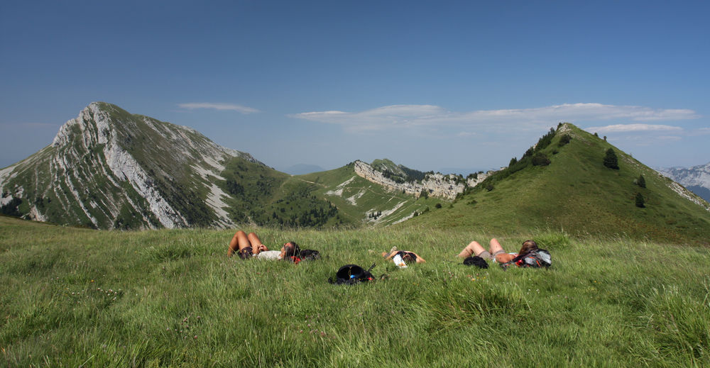
This hike, starting from the Col de la Charmette (cul de sac) in Proveysieux, offers exceptional mountain pastures that will not leave you indifferent.
The characteristics of the route.

Proveysieux (38)
- Distance 14.3 km
- Elevation gain 880 m
- Elevation lost 880 m
- Min. elevation 1262 m
- Max. elevation. 1867 m
- Duration (depending on pace) 5h30
- Marking Yes
Marking : Departure signs are placed in the villages at parking or public reception points.
To follow your route, posts are set up at crossroads and identifiable by a plate indicating its name and altitude.
Between two posts, markings in paint mark out the path to follow or not. You can also be guided by small staking signs.
Recommended "Walks and hikes in the Chartreuse" card.Opening : From 15/05 to 30/11.
Subject to favorable weather.Step by step description : From the Col de la Charmette parking lot, head towards the Chalet de la Charmette and climb towards the Col de la Grande Vache along a forest track.
From the Col de la Grande Vache, descend to the Col de la Sure and climb to the summit of the Grande Sure on a round trip (approx. 1h). Continue the loop through the mountain pastures to reach Hurtières and then the pass of the same name.
Continue south to the Vavarey meadow and then descend to the Col de la Charmette.
Ideas for visits close to the route :
- Fromagerie et ferme de Plantimay (16km from the start): visit the farm.
- Grottes de St Christophe (19km from the start): guided tours.
- Chartreux cellars and distillery (28km from the start): visit the world's largest liqueur cellar.
For more information and other ideas, visit chartreuse-tourisme.com/rsf
Information / safety :
- To make the most of your walks and hikes in complete safety, it's a good idea to adopt a few rules and follow a few tips! Before setting off, follow our recommendations and advice on chartreuse-tourisme.com/conseils-rando-trail (or on request from tourist offices).
- A mountain leader is a specialist in mountain fauna and flora, off-trail hiking away from the crowds, local history, alpine and farming traditions, etc. in complete safety! Just ask! Detailed list on chartreuse-tourisme.com/accomp (or at tourist offices).
- You hike under your own responsibility. Chartreuse Tourisme and the tourist offices cannot be held responsible for the itineraries proposed.
Useful numbers :
- Meteo (please consult before setting off): 3250 or www.meteo.fr
- Mountain rescue: 112
Area : Grenoble-Alpes Métropole
Report a problem
Website Pdf file Features of the application :
- Location and orientation on detailed maps thanks to the GPS of your smartphone
- Description of routes and points of interest on the route
- Photo gallery by route
- Detailed elevation profile
- Route tracking alert to warn you if you stray from the route
- Send predefined messages by SMS to your contacts
- Emergency module: trigger a call or send an emergency SMS in case of problem
- Agenda: access to events organized in the department
- News: find in the application the latest news on the web portal
- Adding achievements
- Add reports in case of problems encountered on the routes
- Share on social networks
Add your time and share your feelings
Services nearby

Col de Porte
Sarcenas

Museum of la Grande Chartreuse
Saint-Pierre-de-Chartreuse
Location de matériel au foyer de ski de fond
Saint-Pierre-de-Chartreuse
Museum of Contemporary Sacred Art
Saint-Pierre-de-Chartreuse

Coeur de Chartreuse Tourist Information center at Saint Pierre de Chartreuse
Saint-Pierre-de-Chartreuse


Follow us on
the digital trails
the digital trails


![]()
The Isère Outdoor application was created
by the Département de l'Isère
Infos & contact
Conseil départemental de l'Isère
7 rue Fantin Latour
CS 41096
38 022 Grenoble cedex 1
Tel. 04 76 00 38 38
 Isère Outdoor - Parcours - La Grande Sure by the Col de la Grande Vache
Hello, world! This is a toast message.
Isère Outdoor - Parcours - La Grande Sure by the Col de la Grande Vache
Hello, world! This is a toast message.
Isère Outdoor - Parcours - La Grande Sure by the Col de la Grande Vache
Hello, world! This is a toast message.


OK
Annuler